Cllr McCarthy’s Community Talent Competition 2015

  Cork’s young people are invited to participate in the seventh year of Cllr Kieran’s McCarthy’s ‘Community Talent Competition’. The auditions will take place on Sunday 10 May 2015 between 10am-5pm in the Lifetime Lab, Lee Road. There are no entry fees and all talents are valid for consideration. The final will be held two weeks later on Saturday 23 May. There are two categories, one for primary school children and one for secondary school students. Winners will be awarded a perpetual trophy and prize money of €150 (two by €150). The project is being organised and funded by Cllr Kieran McCarthy in association with Red Sandstone Varied Productions (RSVP). 

   Cllr McCarthy noted: “The talent competition is a community initiative. It encourages all young people to develop their talents and creative skills, to push forward with their lives and to embrace their community positively”. Further details can be got from the talent show producer (RSVP), Yvonne Coughlan, 086 8764685 or email rsvpireland@gmail.com.

Kieran’s Our City, Our Town, 7 May 2015

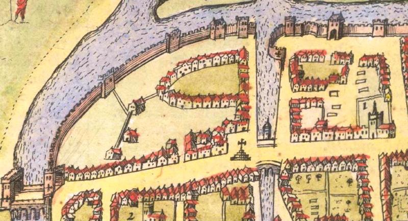
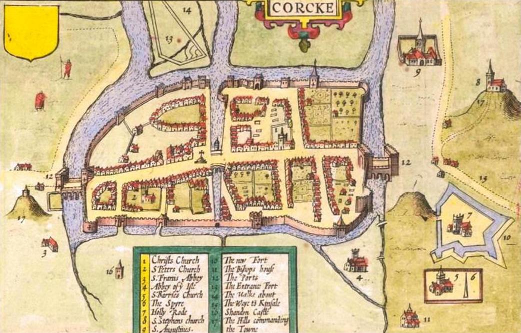
791a. Plan of Shandon Castle, from Map of Cork, c.1600

Kieran’s Our City, Our Town Article,

Cork Independent,  7 May 2015

Cork Harbour Memories (Part 22)

Tales of Old Shandon


   By April 1600, Shandon Castle had become confiscated and it became the official residence of George Carew, the Lord President of Munster. It became the centre of English power in the south of Ireland. Sir John Perrott, Sir Warham St Leger, Sir Walter Raleigh, Edmund Spenser and other Elizabethan notabilities held court and council within its halls.

    In the first couple of months Carew described the defences of Cork as remarkably weak and not been able to withstand foreign attack from the Spanish navy in particular. In his opinion a strong garrison there was no use against an army that was masters in the field of war. Carew devoted much time to creating dissensions amongst the Munster chiefs who seemed likely to aid the invaders. In June 1601, James Fitzthomas, Earl of Desmond, was brought from Kilbehenny to Shandon Castle, and at the same time, Florence McCarthy More was treacherously arrested and detained there. Both were dispatched to the Tower of London for beheading. At this time there was a suggestion that Shandon Castle be demolished to keep it out of enemy hands. The discussion ended with no commitment to destroying the castle and that it would serve no military purpose, for every hills and ditch around the city commanded it just as well as Shandon did.

   An article by John T Collins in the Journal of the Cork Historical and Archaeological Society in 1943 describes the fortunes of Richard Boyle, Earl of Cork. Boyle left Shandon Castle on the Monday morning following the English win at the Battle of Kinsale to convey the news to Queen Elizabeth. In the aftermath of the battle many Irish gentlemen were tried at Shandon for treason. Amongst them was Dominic Collins, the Jesuit friar, captured at the Siege of Dunboy. Carew ordered Dominic and two others to be kept prisoners after the siege while the rest were hanged in the market-place, fifty-eight on that day, and the remaining twelve four days later. The three surviving prisoners were brought to Cork for interrogation. As the other two had little to reveal, they were soon executed. But Carew interrogated Collins, hoping he could persuade him to become a Protestant and thus gain a propaganda victory. He alternately tortured Dominic and made him promises of elevation to high ecclesiastical office.

   Some of Dominic’s own family visited him, urging him to save his life by pretending a conversion which he could afterwards repudiate. But Dominic would have none of it, and made a choice of a martyr’s death. Taken to Youghal on 31 October 1602, he was marched by a troop of soldiers through the streets to the place of execution. Left hanging on the gallows, the rope eventually broke and Dominic’s body fell to the ground. Under cover of darkness, local Catholics took his body away and buried him with respect in a secret place. From that day he was venerated as a martyr in Youghal and his fame quickly spread throughout Ireland and Europe. In the Irish Colleges of Douai and Salamanca the Jesuits showed his portrait and many favours and cures were attributed to his intercession.

   Fast forward in time, and in 1603, the Mayor and Council of Cork refused to proclaim the new king, James I. Lord Roche made the proclamation from Shandon Castle. The citizens put Cork in a state of defence and demolished Elizabeth Fort so that it could be used against them. Lord Mountjoy arrived with an army and made them submit. One of the penalties imposed was that they should rebuild the fort they had broken down.

   In March 1689, James II landed at Kinsale and came to Cork. He is said to have received the Earl of Tyrconnell, his Lord Lieutenant of Ireland, and his principal officers of state in Shandon Castle. Cork remained faithful to James II after the Battle of the Boyne, which led to John Churchill, Earl of Marlborough coming to Cork in an effort to reduce it to submission. In September 1690 Churchill drew cannons to Fair Hill and threatened Shandon Castle and its defenders, whose defenders withdrew inside the city walls. The troops occupied the castle and bombarded the city.

    The suburbs, which were burned during the siege, were eventually rebuilt. Those around Shandon Street were in particular heavily damaged. St Anne’s Shandon was built in 1722 to replace the older church of St Mary’s, Shandon, which was destroyed in the siege of Cork in 1690 by English forces. The architecture of the church and tower is an early English style. The peculiar feature of the tall church tower approximately forty metres in height is that the north and east sides are comprised of red sandstone while the south and west sides are composed of grey hewn limestone. The limestone came from the ruins of the Franciscan Abbey, which existed on the North Mall while the sandstone came from Shandon Castle. Rising from the main tower, which is in the shape of a telescope, are three further tiers, which end in a curved dome. In 1770, any remaining ruins of Shandon Castle were cleared to make way for a complex of buildings belonging to the Butter Market.

To be continued…


Captions:

791a. Plan of Shandon Castle, from Map of Cork, late sixteenth century as depicted in Sir George Carew’s Pacata Hibernia, or History of The Wars in Ireland (1633), vol. 2, opp page 137.

791b. Shandon Castle from A description of the Cittie of Cork/ Plan of Cork, circa 1602 by George Carew (source: Hardiman Atlas, Library of Trinity College Dublin)

791c. St Anne’s Church, Shandon (picture: Kieran McCarthy)


791b. Shandon Castle from A description of the Cittie of Cork

791c. St Anne’s Church, Shandon

Kieran’s Our City, Our Town, 30 April 2015

790a. Depiction of Shandon Castle, c.1603

Kieran’s Our City, Our Town,

Cork Independent, 30 April 2015

Cork Harbour Memories (Part 21)

Shandon’s Old Castle


      George Carew’s map of Cork, c.1600, places an emphasis on a two towered structure called Shandon Castle. Aligning old maps with newer ones of the city through the ages the Castle was on the site of what is now the Firkin Crane. Between 1599 and 1600, Carew, Lord President of Munster, having undertaken his suppression of rebellion, took up his quarters at Shandon Castle, overlooking the walled town of Cork and its adjacent hinterland which he wished to watch over. It was a building of great physical and symbolic strength. Courts for criminal cases were frequently held here by the Lord President and the judge on circuit. Persons who rose up against the Munster Plantation were likewise imprisoned there.

     Urban myth pitches Shandon Castle as standing on the verge of a precipice overhanging the Lee. It has been depicted as a kind of medieval castle keep with a large portcullis gate. Steep stairs called the Giant’s Steps leading to the nearby river Lee were cut through this precipice. An article by Rev James Dwyer in the Journal of the Cork Historical and Archaeological Society in 1897 notes that the steps were removed in the 1860s (possibly to create the laneways that now exist in the area, for example Rowland’s Lane and surrounds). The street adjoining the castle was popularly known by the name of Shandon Castle Lane, which is now Dominick Street.

     The castle is originally is said to have been built initially by the Prendergasts. It passed to the De Cogans and the Barrys and served as a manorial feudal centre until Carew’s arrival. Kenneth Nicholls argues in Cork: History and Society (1993) that in the early fifteenth century that Shandon Castle and its vast territory which at one time was controlled by the Cogans, Barrys Rochfords and the Earls of Kildare.

    Woulfe’s Irish Names and Surnames (1923) highlights that the Barry surname occurs in the earliest Anglo-Irish records, and has always been specially associated with the County of Cork. In the year 1179, Robert FitzStephen granted to his nephew, Philip de Barry, the three cantreds of Ui Liatháin, Muscraighe-trí-máighe, and Cinel Aodha, represented in time by the baronies of Barrymore, Orrery, and Kinalea. This grant was confirmed by King John in 1207 to William de Barry, son and heir of Philip.

   In the course of centuries the Barrys became one of the most numerous and powerful families in Munster. They divided into several branches, the heads of which were known respectively as An Barrach Mór (the Great Barry), Barrach Ruadh (Red Barry), Barrach Óg (Young Barry), Barrach Maol (Bald Barry), Barrach Láidir (Strong Barry); and one branch adopted the Irish patronymic surname of Mac Ádaim. The territories of the Barrys were vast. Settlements now situated in the old barony of Barrymore include Bartlemy, Castlelyons, Carrignavar, Carrigtohill, Cóbh, Glounthaune, Bridebridge, Midleton, Rathcormack, and Watergrasshill. Settlements in the old barony of Barrymore today extend from Kanturk through Mallow, Ballyhea and Buttevant. Settlements existing in the old barony of Kinalea extend from Inishannon to Belgooly, Carrigaline, Nohoval, Minane Bridge and Tracton.

    The Barrys originally settled around Buttevant in north Cork, named after the family motto, boutez en avant, meaning ‘strike forward’. With the approval of King John, they built a great castle on the banks of the Awbeg River. A settlement developed around the castle. In recent years, much local work has been pursued in creating historical walking tours of Buttevant’s old medieval spaces. Plaques around the town records that David de Barry I was responsible for the development of Buttevant as a borough for which Henry III granted him rights to hold a market and fair in 1234. In 1229 the Barrys built Ballybeg Abbey for the Augustinians, which has is regarded as the finest columbarium (dove house) in Ireland. In 1251 Buttevant Friary was built by David Óg Barry for the Friars Minor of St Francis. The control by the Barrys over their land manifested itself through the foundation of a number of other boroughs and religious houses. Members of the family were associated with the Franciscan and Dominican foundations in Cork city, the Franciscan friary of Timoleague (c. 1312), and the Carmelite friary of Castlelyons (1307-9).

   Barryscourt Castle remained in ownership of the most powerful branch of them all, known as the Barrymores. However, the Barrymore lines died out and were passed onto a distant cousin by the name of James Fitzgerald of the Barryroes in 1556. The present tower house of Barryscourt Castle is said to be constructed in the fifteenth or sixteenth century and became a principal seat of the Barrys. The Barrys supported the Desmond rebellions of 1569 and 1579, and in 1581 they destroyed or severely damaged their family castles to prevent English forces from capturing them, including Barryscourt, which was threatened by an army led by Sir Walter Raleigh. After the suppression of the second rebellion, the Barrys were pardoned by Queen Elizabeth I and Barryscourt was repaired, with an outer wall or bawn surrounding an inner courtyard being added, including 3 corner towers. Barryscourt ceased to be main residence of the Barry family in 1617.

To be continued…

 Captions:

790a. Depiction of Shandon Castle, c.1603 (source: Cork City Museum)

790b. Barryscourt Castle, present day (picture: Kieran McCarthy)

790c. Buttevant Friary, built in 1251 by David Óg Barry for Friars Minor of St Francis and dedicated to St Thomas A Becket (picture: Kieran McCarthy)


 790b. Barryscourt Castle

790c. Buttevant Friary, built in 1251

Kieran’s Question to the City Manager/ CE and Motions, Cork City Council Meeting, 27 April 2015


Question to the CE/ Manager:

To ask the CE when the partial clean-up of the hoarding on Penrose Quay, detailed in a reply by the CE on 12 January 2015 will begin. The hoarding has since collapsed and has revealed a very ugly situation (Cllr Kieran McCarthy).


Motions:

That the City Council install traffic calming measures on Wallace’s Avenue (Cllr Kieran McCarthy)

Rooted in Community, Kieran’s Comments, Ballinlough Community Association AGM, 21 April 2015

Trees and Roots:

 Madame chairperson, ladies and gentlemen, colleagues, thank you for the invite this evening.

 If there was ever a corner of the world, whereby nature always stamps its unique identity it is this corner of the Rebel capital. As each Spring rolls around, the cherry blossom trees in Ballinlough appear as if in defiance of our damp and cold winters and are proof that spring has finally arrived. Spring offers renewal, re-birth, growth, hope, re-imagination and inspiration. The dark evenings end as the daylight lengthens. It’s hard not to romanticise about the blossoms and their effects on all those who drive and walk the local roads.

  They add immensely to the sense of place and identity of this area. It’s as if the blooms want to say ‘remember us’, ‘wonder in us’ be inspired; they are in their own way, part of the city’s cultural DNA, a piece of life, a way of life, the trees are always in flux…their roots spreading into the undulating topography of Ballinlough, pushing up, dislodging the footpaths and roads in the park below and in the Japanese gardens.

   Cork songwriter John Spillane writes of Cork’s cherry blossoms “as putting on the most outrageous clothes and they sing and they dance around”.

   The Vita Cortex workers in their struggle in 2012 commented on the cherry blossoms on Pearse Road;

“They stand tall like us, magnificent in their beauty. They sway in the wind and bend with it but remain unbroken. They have been there lining the street as long as any of us can remember… they are part of the local landscape and history, The cherry blossom trees are like sentries guarding the road to the factory; our home, our workplace”.

   The blossom trees offer a fleeting beauty every spring, where you do nod and look in passing. And all too soon the blossoms fall and are relegated to another season passing. And with each bloom, another year comes around and that sense of renewal hits in again.


 Casting Shadows:

    But the blossoms in a place such as the Japanese Gardens were not always there. They cast shadows over the now fading memory of Douglas Nurseries, run by Atkins. Sixty years ago, a Welsh accent wafted in the air at this site as the site Manager Mr Jones went about his work. Mr Wolfe, enthusiastically looked on heading up the operation – the acts of making and nurturing something to grow and sowing seeds. There were 12-14 people working there. One of the lads was an old gentleman, Con O’Sullivan from Ballinlough. Where now St Anthony’s School is, there was a wall across there and that was the boundary of the nurseries. Inside that wall were the fruit trees. The premises extended all the way down to Douglas Road. There were several greenhouses in which tomatoes and flowers were grown. Outdoors, shrubs and fruit trees were also grown. One of the biggest jobs in Atkins was to make the compost. John Innes was a very famous brand in its day and we used to make it from various ingredients.

   As the late fifties developed the extent of Wolfe’s acreage lessened. Dave Bradley of Bradley Brothers was also making and sowing seeds in a sense. They were turning one house a week at one stage in the 1950’s and 1960’s. It was amazing how fast they moved. It’s amazing what they created. By the time they were finished one house they were moving onto the next. They built almost 1,500 houses in Ballinlough from Browningstown East, Ardmahon and Ardfallen estate, all the estates with Somerton; they did Beechwood Park and Belmont Avenue. At the top of Atkins, they developed what was deemed the good building land, which became Beechwood by the mid 1960s, fifty years ago. Dave Bradley’s mother liked trees and thought Beechwood would be a nice name for the estate.


Educational and Social Needs:

    Meanwhile the local clergy of the new parish of Ballinlough, just five years old in 1960 had their work cut out to embrace their new parishioners, mostly young and white collar workers, who in time gave Ballinlough a youthful population, who kicked ball around Ballinlough’s new roads, sat with Derry Cremin in Jock’s Murphys and discussed tactics for the next hurling match. In its demise, they harnessed the eventual ruins of Atkins for adventures, slocked apples from the various orchards from here, that of Hennerty’s to Kelly’s orchard on the site of The Orchard Bar to further afield and created landscapes of cowboys and Indian across the vast market gardens of Ballinlough.

    Fifty years ago, Ballinlough was a relatively young parish and community. It had the usual needs of a young growing community, which are educational, recreational and social. The parish priest of the time, Canon Eddie Fitzgerald, with the help of his priests and people, courageously faced those challenges. Indeed, amongst those young priests who came under the wing of the Canon Fitzgerald was Fr now Canon Michael Crowley.

   There were three schools in the parish, Ballinlough old boys school at the Silver Key, and Our Lady of Lourdes in Ballinlough and Crab Lane off Boreenmanna Road. These schools were totally inadequate to cope with the growing numbers of young boys and girls. Thornhill House was bought by the parish to provide temporal classrooms for the overflowing number of boys.

   Then Eglantine House on the Douglas Road was bought and converted into a school, opening in 1959. It was seen as a temporary solution to the growing number of girls in Ballinlough and surrounding areas. So great was the demand for places that stables in the yard belonging to Eglantine House had to be converted into classrooms. In time this temporary school was replaced by a new beautiful Eglantine school and the beautiful tree, which beset the ground was removed.


St Anthony’s School:

    The local Canon Fitzgerald, who was an elderly gentleman, had multiple interests especially in education. He became the first parish priest in 1955. His grandfather was Lord Mayor of Cork, Sir Edward Fitzgerald. He was the key instigator of the Cork International Expedition on the Mardyke in Cork City in the years 1902 and 1903. Energy and foresight ran in the Fitzgerald family. On one morning in the early 1960s, he and his curate, Fr Jeremiah Hyde set off searching for a new site for a boys school. They agreed that perhaps the upper half of the property of formerly Atkins Nursery could be built on. By the early 1960s the property had become that of Cork Corporation. Fr Hyde drove the Canon to Cork City Hall where he had a chat with city planners and the idea for the site of St Anthony’s School was born. People got together and raised funds for this new school, which we all now know as St Anthony’s. The rest is history with school celebrating its fiftieth anniversary this year.

   By the late 1960s, Ballinlough National School for boys as such was spread out in different buildings. You had the new building of St Anthony’s, Thornhill House, and there was the old national school near the Silver Key bar. Jack Corkery was the principal and his wife was principal in Eglinton School, which had opened in 1959. With the St Anthony’s complex, there were about eight or nine on the teaching staff. Vice-Principal Bart Whooley was also a respected teacher.

   Fifty years ago, the more relaxed confirmation process we enjoy today was more formal with Bishop Lucey sweeping through putting the sixth class to the test on all matters Godly. A stern man but ambitious for the city’s new suburbs with his amazing and architecturally exciting Rosary churches, coupled with schools and community centre. In the late autumn of 1959 while in the United States, Bishop Lucey, Bishop of Cork and Ross, impressed by the work of many Parish credit unions he saw in operation. During the visit he collected as much information as possible on the principles and practices of credit union. On his return to Cork, Bishop Lucey used every opportunity to promote the concept of a credit union.

    Fifty years ago, in the late summer of 1965 Fr John Ryan of Our Lady of Lourdes Church called a meeting with John Corkery, Dermot Kelly, and Paddy Hennessey in Thornhill House to sound out the idea of forming a credit union in Ballinlough. All agreed that it was an excellent idea and an immediate start was agreed upon. A working group consisting of five members attended a further meeting in September of 1965. The credit unions already established in the city, had initially started up study groups to explore the possibility of introducing the philosophy of credit union to their parishioners. It was agreed to follow this formula in Ballinlough, and that membership of the group would be by invitation only.

   The first meeting of the study group (by invitation only) was held at Thornhill House on 16 November 1965. There were twenty-two people, all male, in attendance and there was a pretty wide representation consisting of tradesmen, factory employees, clerical workers, a clergyman, school principal and a member of the legal profession. This represented a well-balanced reservoir of talent. Fr Ryan was proposed as group chairman and Paddy Hennessey as secretary. Fr Ryan agreed to act as chairman if the position rotated at each subsequent meeting.


The Weight of History:

   The roots of all these seeds from fifty years ago – the houses, estates, schools, the credit union – like the roots of the blossom trees run deep. The weight of history, past events, glory days, the voices and stories of thousands of individuals who have come through the driveway gates of houses, our schools, our Credit Union are all important to this area’s identity and sense of place – their roots remain strong fifty years on this year and needs to be continued to celebrated, explored and the lessons and messages of the past brought to bear in forging a future. The energy and aspiration of fifty years has survived into our time inspiring many community leaders in our time and they have the potential to inspire more.

    As we enter the lead –up to the commemoration of 1916, I think there are messages concerning inspiration will appear more and more in the next year. Just like the power of the blossom trees, threads such as renewal, re-birth, growth, hope, re-imagination and inspiration will spread through the nation’s psyche in the next few months.

  Thank you for your continued courtesy towards myself. You always learn something new about yourself in Ballinlough, indeed here is a place where you get stopped on the road for a chat, are challenged, encouraged, supported, helped and always pushed!

I would also like to thank the people of Ballinlough for their interest and support in my own community projects over the last six years now.

The Discover Cork: Schools’ Heritage or Local history project

The local history column in the Cork Independent, in the books I have been lucky to publish.

the community talent competition, which I have audition for

The Make a Model Boat Project on the Atlantic Pond, which is on 31 May,

and the walking tours through this ward; there are now ten of these – developed over the last number of years –

   As a new project to this great city, I have set up a musical society, Cork City Musical Society, so I’m directing and producing my first musical in early June in the Firkin Crane in Shandon. Also recently I have been appointed by the Minister of Environment as an Irish delegate to the EU’s Committee of the Regions, which meets in Brussels every six weeks for two days. The 350 member committee gives advice to the European Parliament on local authority issues. So hopefully there will be something there I’ll find that will benefit Ballinlough or share the positive community projects that go on here with other EU countries. I sit on two committees or commissions, the EU budget assessment committee, and the culture and youth unemployment one, so there is alot there to debate and bring about change in the wider picture again.

   I think as an area in the Council Ballinlough was lucky before the economic crash in attaining as much as it could in physically making it a great place – In the last five years the Council’s coffers have been slashed by 45 million euros– something that can be seen visibly on our streetscape – roads decay and crumble, hedges become overgrown, Douglas Pool has not been dealt with to make it into the place that this area needs; these are uphill battles as a Council we face and we must find solutions. All the old parks are rebooting with young families, our schools are packed to capacity, you can see that with the traffic chaos every morning and afternoon. I think as an area we need a proper playground and a multi-use games arena, which is something I continue to fight for in City Hall.

   I found last year in the canvass that the older people are being looked after by family and neighbours but do yearn to have a chat to people. The feedback I am getting is that there is certainly a need for a drop-in centre once a week or fortnight – perhaps in this building or in the church. There is certainly a need to hold and continue the work of the Meals-on-Wheels, the bowls Club, our tennis club, and the work of our youth club. The lack of volunteers coming forward is always apparent; we also need to have a chat to the secondary schools on the parish’s borders to build a new audience as such of interested volunteers.

   We have been fortunate with the top table’s leadership over the past 7-8 years. That been said I would like to see a change of the guard – keep the organisation moving in a fresh way. I think it has been great to see many organisations getting their chance at holding the chairperson position; I would like to see someone from the Youth Clubs getting a go and seeing what they can muster as the association climbs through renewal in our country. I think new blood would renew the association’s partnership with the community as well. I say this in a respectful manner and not to offend people.

   I’d like to thank the various organisations represented here for all their hard work. It is no easy task but one I know you deem important to pursue.

   Best of luck in the year ahead – the more optimism and solutions that are radiated from this hallowed community space and grounds the better in these times. In these AGMs, there should always be the sense of thanks and just like the blossom trees a renewal of spirit. Thank You.

Ends


Reference:

McCarthy, K, 2013, Journeys of Faith, Celebrating 75 Years, Our Lady of Lourdes, Ballinlough, Cork.

Kieran’s Our City, Our Town, 23 April 2015

789a. Museum image of abandoning ship, Mary Rose, 1545

Kieran’s Our City, Our Town Article,

Cork Independent,  23 April 2015

Cork Harbour Memories (Part 20)

Living on the Tides


   George Carew in his Map of Cork, c.1600 gives a representational focus on Tudor style ships. To the viewer of Carew map, they are meant to be symbolic of a strong empire and a well protected port such as Cork. For all intensive purposes they were floating fortresses. They were highly structured communities, large in population numbers, under a chain of command. Large numbers worked and lived on such small structures under the command of officers. Dependent on the tides and winds, these ships were part of a wider maritime identity that defended the islands of Great Britain and Ireland from attack. They were always on standby to protect and defend.

   There is no evidence that the early sixteenth century Tudor ship the Mary Rose (discussed last week) ever arrived into Cork. Its example does shine a light on the communities who worked on the open seas and how these seas were the highways of their day, which connected the north-western European cities together. The findings during excavation and research of the Mary Rose provide insights into the workings of a ship’s community. Apart from almost half a ship, approximately 19,000 artifacts have been recovered from the wreck site. Excavations of the 1545 wreck have also found the personal remains of many of the crew members. The information I supply here can be found in the special museum created around the ghostly and ruinous ship wreck in Portsmouth.

   Records say that the ship carried 200 mariners, 185 soldiers, 30 gunners and the officers. Everyone on board the Mary Rose was male. She also carried the captain, and his attendants, a master, a pilot, a purser, a surgeon and his assistant, and carpenters. There may have been over 500 men on board when the ship sunk. Of these no more than 35 survived. Of the 500 men, only three of their names are known – a Sir George Carew (not Cork’s map maker) who was the Captain and the king’s vice admiral. The pieces of a fine set of pewter tableware are all marked with the initials ‘GC’. Roger Grenville was on board, probably commanding a group of soldiers. The cook may have been called NY Coep.

   Below decks, it was cold in the winter and stiflingly hot in summer. All year round, it was damp, with a strong smell of tar, stagnant water and sweating unwashed men. For the most part it was also dark. On the main deck, the only light came from openings in the centre of the deck, from ventilating hatches above each gun, or from the gun ports when the lids were open. Otherwise light came only from candles. Officers and professional men like the Master Carpenter and the pilot slept in cabins. The crew had only the hand deck. Only some elite soldiers may have had uniforms, the rest wore their own clothes. Not all of the men had a change of clothing, so if it was stormy or raining when they were on the open decks or in the rigging, it would be a long time before they could get dry. On the excavation, they found no evidence of toilets. Studies of the skeletal remains of at least 179 individuals revealed that most of the men were in their 20s. The youngest was around ten years old and the oldest over 40. On average the men were 1.71 metres tall, only slightly smaller than Irish and UK men today.

   The compasses from the Mary Rose are the earliest known steering compasses on gimbals – pivots – in the Western world. Each sat in a case suspended on gimbals, which allowed the compass needle to stay level whatever the motion of the ship. The gimbals were made of brass strips so they did not affect the magnetised iron needle. The needle was fixed underneath a card marked with the points of the compass, so that both the card and needle moved when the ship changed direction. The sixteenth century saw tremendous advances in the science of navigation. Seamen had evolved rule of thumb methods of using the sun, stars and moon for direction finding since time out of mind, but now the scholar and the pilot were to work in unison in Portugal. The pilot was taught to use instruments and it is interesting to note that Sir Francis Drake used Portuguese pilots.

    The Mary Rose carried both wrought iron guns and bronze guns – products of two very different methods of manufacture. Wrought iron guns could be made in any village blacksmith’s forge by heating, hammering and welding. Bronze guns had to be made in special foundries, where up to three tons of molten metal were poured in a single casting. Bronze guns were much more efficient and could fire their shot much further than wrought iron guns. But the copper needed to make the Bronze was very expensive and Henry encouraged attempts to mass produce small guns cast in iron. In the first decade of his reign, Henry encouraged continental gun founders to open workshops in London. All were decorated with a royal emblem, a metaphor of an empire.

To be continued…


Caption:

789a. Museum image of abandoning ship, Mary Rose, 1545 (source: Mary Rose Museum, Portsmouth Historic Dockyard)

789b. Museum image of Mary Rose, c.1540 (source: Mary Rose Museum, Portsmouth Historic Dockyard)

789c. Pewter plates from the wreck of the Mary Rose (source: Mary Rose Museum, Portsmouth Historic Dockyard)

789b. Museum image of Mary Rose, c.1540

789c. Pewter plates from the wreck of the Mary Rose

Cllr Kieran McCarthy calls for fair geographical distribution in the Investment Plan and focus on small scale projects

Cllr Kieran McCarthy speaking at Committee of the Regions, Plenary 16 April 2015

Cllr Kieran McCarthy calls for fair geographical distribution in the Investment Plan and focus on small scale projects
 
   Local and regional politicians from across Europe last week presented their proposals to improve the € 315bn EU Investment Plan launched by the European Commission. The European Committee of the Regions (CoR) adopted its position on the EU regulation of the European Fund for Strategic Investments (EFSI), established by the Plan.
 
   Independent Cork City Councillor Cllr Kieran McCarthy participated in the lively debate and highlighted the importance of reaching out all regions and ensure the funds are also directed to small regions and small scale projects.  In this respect he calls for the CoR to be involved in the governance process of the Fund to ensure fair distribution of investments.
 
   Finally he urges the European Commission to clarify how the investment plan will impact on local communities given that the investors control most of the funds and the success of the Juncker Plan heavily dependent on their finance. There needs to be a mechanism to ensure real delivery of clear added value projects for citizens.
 
The Committee of the Regions
 
   The European Committee of the Regions is the EU’s assembly of regional and local representatives from all 28 Member States. Created in 1994 following the signing of the Maastricht Treaty, its mission is to involve regional and local authorities in the EU’s decision-making process and to inform them about EU policies. The European Parliament, the Council and the European Commission consult the Committee in policy areas affecting regions and cities.  There are 9 Irish members in the Committee of the Regions

Kieran’s Our CIty, Our Town, 16 April 2015

788a. Conserved remains of Mary Rose, Tudor ship, Portsmouth Historic Dockyard 2014

Kieran’s Our City, Our Town Article,

Cork Independent, 16 April 2015

Cork Harbour Memories (Part 19)

Tudor Ships on the Lee


      George Carew’s Map of Cork or plan of the walled town of Cork is different to that of Muskerry. Dated to the late sixteenth century, sometime in the 1590s perhaps, the map depicts numerous structures, which emphasise Cork as a port and a place to be protected as an English outpost of trade. The town walls, the Tudor ships, and the suburban features such as abbeys and watch towers show a town prepared for any potential attack and the difficulties of an attack. The river is presented as an integral feature around which the plan is defined. Like the Map of Muskerry, it is an English-made map to control territory. Here a militarised maritime zone is depicted.

     At the heart of the map is Watergate, Cork’s central maritime gate with its associated port, dock and custom house. It would have been impressive in its mechanism in opening to leave ships in. The gate allowed access into a private world of merchants and citizens. The masts of ships moored would have creaked as they knocked against the stone quays. Built between two marshy islands, in the middle of a walled town, its entrance was between the two castles – King’s Castle and Queen’s Castle. Castle Street now occupies a section of the interior dock.

     Carew in his map places an emphasis on two Tudor style galleons at the base of his plan – one revealing its starboard side and the other its port side – both have their sails filled with wind – lines, ropes and ladders are almost frozen in an action to move; canons appear through the port holes as if ready for attack. The depiction of the two ships like this can only be speculated upon. Certainly the ships symbolise the link to the protection of the waters of the town and the wider harbour and the role of the English and local navy in its protection. They were symbols of Cork’s presence in a north-west European maritime culture. They were a reminder that to enter the River Lee estuary you would be met by force. Your ship was probably watched from the harbour mouth all the way up the Lee Estuary to the walled town.

   The reality of these galleons was far from comfort. The map does not show the enormous amount of crew needed to manoeuvre such ships. These vessels were large ocean going ships, four times as long as they were wide. They had a special deck for cannons. They were broad, slow and not very manoeuvrable. All year round, the interior of a galleon was damp, with a strong smell of tar, stagnant water and sweating unwashed me. For the most part, they were also dark. On the main deck, the only light came from openings in the centre of the deck, from ventilating hatches above each gun, or from the gun ports when their lids were open. Other light came only from candles.

   In an attempt to find out more about the workings of and symbolism surrounding Tudor ships, in recent months I travelled to Portsmouth to explore their historic dockyard and heritage complex. One of their purpose-built museums gives public access to view the ghostly timber ruins of the Tudor ship Mary Rose. Half of the ship was lifted from the sea-bed in October 1982, and is now undergoing conservation, as well as over 22,000 artefacts found on board, at Portsmouth. This major project provided opportunities to understand the ship, her essence, her weapons, equipment, crew and stores.

    The interpretative panels there reveal that the Mary Rose was built at Portsmouth between 1509 and 1511. Named for Henry VIII’s favourite sister, Mary Tudor, later queen of France, the ship was part of a large expansion of naval force by the new king in the years between 1510 and 1515. Warships, and the cannon they carried, were the ultimate status symbol of the sixteenth century, and an opportunity to demonstrate the wealth and power of the king abroad. The Mary Rose remained the second most powerful ship in the fleet and a favourite of the king. She was deemed to be a fine sailing ship, operating in the Channel to keep up links with the last English landholdings around Calais. She was a carrack, equipped to fight at close range.

   The Mary Rose was rebuilt in the 1530s. Her 1536 rebuild transformed her into a 700-ton prototype galleon, with a powerful battery of heavy cannon, capable of inflicting serious damage on other ships at a distance. The high castles (combat structures above deck) were cut down, decks strengthened, and she was armed with heavy guns, with 15 large bronze guns, 24 wrought-iron carriage guns and 52 smaller anti-personnel guns. The Mary Rose now had the firepower to engage the enemy on any bearing, and conduct a stand-off artillery battle. Some of the guns were mounted on advanced naval gun carriages, which made them far easier to handle and move on a crowded gun deck. The new emphasis on artillery reflected the mastery of gun founding in England, another development pushed by Henry VIII. It also reflected the need for a naval force to defend the kingdom against European rivals.

 To be continued…


Captions:

788a. Conserved remains of Mary Rose, Tudor ship, Portsmouth Historic Dockyard, 2014 (picture: Kieran McCarthy)

788b. Map of Cork, late sixteenth century as depicted in Sir George Carew’s Pacata Hibernia, or History of The Wars in Ireland (1633), vol. 2, opp page 137.

788b. Map of Cork, late sixteenth century


Kieran’s Question to the City Manager/ CE and Motions, Cork City Council Meeting, 13 April 2015


Question to the City Manager/ CE:

To ask the CE why has the complimentary offer by the Council of erecting tribune banners on the Sarah Flannery lights in the city centre for festival bodies been stopped? I understand that the Council now wish to have circa E.6,000 for such banners to be put up? The banners are a great way of letting citizens know about upcoming festivals and events (Cllr Kieran McCarthy)


Motions:

That speed limit and speed warning signs be erected on Douglas and South Douglas Roads (Cllr Kieran McCarthy)

That ramps and speed limit signs be erected on Blackrock Road leading down from the St Michael’s Church to the pier (Cllr Kieran McCarthy)

Kieran’s Our City, Our Town, 9 April 2015

787a. Kilcrea tower house, March 2015

Kieran’s Our City, Our Town Article,

Cork Independent,  9 April 2015

Cork Harbour Memories (Part 18)

Stories in Stone


   Staying with George Carew’s map of sixteenth century Muskerry (see last week), one of its concerns was the showing of castles and churches – his castles are marked with a circle and a dot whilst his churches are demarcated with a snowman type delineation. The dashed lines reflect fluctuating territorial lines between Gaelic families and Carew’s long list of allies and adversaries. The map also points to small woodland areas across the territory. Carew’s circled dots very much under represent the prominence of castles in the landscape. The majority were tall slender stone tower houses with an estate surrounding them. Many still stand as ruins, haunted in a sense by the human life that once drove survival and civilised structures in them. All are worthy of remark and all have been written about through the ages.

   The tower house at Kilcrea was built by Cormac MacCarthy in the mid fifteenth century and lies only a few miles from Cork City. In its heyday it provided a buffer area like Blarney Castle – that those who travelled west along the River Lee, knew they were entering retaken Gaelic territory. The name Kilcrea (Cill Chre) harks back to an earlier history and means the Cell of Cere, Cera or Cyra. St Cere, who lived in the sixth century. She is is said to have founded a nunnery about a mile east of the friary in the parish of St Owen’s, now called Ovens. It appears that Kilcrea was a location with ecclesiastical associations long before Cormac Láidir MacCarthy founded the Franciscan Friary there circa 1465 AD. The friary was dedicated to St Brigid of Kildare.

   A few fields west of the Franciscan Friary stands the impressive ruined tower house of Kilcrea. It was built by Cormac McCarthy, Lord of Muskerry and was situated nearly in the centre of the valley, within a short distance of the Bride. Although inferior in importance and size, to that of Blarney, it was and still is a considerable structure to walk around and explore in safety. John Windele, antiquarian, in his Historical and descriptive notices of the city of Cork and its vicinity (1839) eloquently describes the castle of Kilcrea as standing in isolation; ”the warrior pile, stands in stern loneliness, denuded of its circling woods, isolated and ruinous – a better taste may again restore to it some of its sylvan honours”.

   This abandoned “warrior pile” of blocks of limestone is like a complex jigsaw puzzle of stone and is well put together. This was a building made to last, made to be permanent. The stones are heavy – their weight now intertwining with the weight of history which now governs them. The quoin or corner stones and the material remains of mortar are testament to the masons who planned and put this prominent structure together. Its site is enclosed by a narrow moat still filled with water. The castle has a small fortified area at the eastern side of it, and is defended by curtain walls, and two square vaulted towers, now in ruins.

   Inside the keep, it is divided by two semi-circular stone arches (being turned on a kind of basket work of interwoven sallows, or willow wattles). One arch is above the other, at the heights of one third, and two thirds of the building. All of the intermediate floors have been destroyed. Stone corbels for timber floors remain to entice the visitor to think about creaking floor boards. The basement rooms like those at Blarney are merely lit by narrow loops. At the south side of the vestibule is a stair case, which consists of an easy flight of seventy-seven steps and runs up the entire height of the building, becoming spiral as it approaches the higher chambers. A number of small closets are attached to the upper rooms, all of which are vaulted.

           The upper chamber formed the main hall – a room of state and was at one time spacious and well lit. Its floor is now overgrown with grass. It was lit by three spacious windows, with stone mullons, and ogee headed tracery of a basic design – but enough to entice you to rub your hand over this ancient piece of art work. John Windele after his visit remarked that at the north side of the main hall chamber, was formerly a “capacious fire place with a well-executed mantle-piece, on the impost of which was an inscription, in raised letters commemorating rather modern repairs”. This was also removed some years before Windele’s visit and during my visit the missing fire-place was also quite apparent. From the ruined battlements is obtained an extensive view over the valley to the west, embracing the view of Castlemore and Cloghdha Castle near Crookstown.

   On my visit the hum of a nearby lawnmower seemed to bounce from wall to wall in the interior, making me look behind you at every corner. The structure is haunted by its stories and history. This haunting feeling is also one, which Windele also picked up upon; “it has been haunted by a phooka, or mischievous spirit, under the form of a black crow; so that nightly visitors would require strong nerves to brave the terrors of its lonely and forsaken chambers”.

To be continued…

Captions:

787a. Kilcrea tower house, March 2015 (picture: Kieran McCarthy)

787b. Interior of Kilcrea tower house, March 2015 (picture: Kieran McCarthy)

787c. Entrance arch and stairs, Kilcrea tower house, March 2015 (picture: Kieran McCarthy)

787b. Interior of Kilcrea tower house, March 2015

787c. Entrance arch and stairs, Kilcrea tower house, March 2015