Kieran’s Our City, Our Town Article,
Cork Independent, 5 November 2015
Cork Harbour Memories (Part 36)
Old Territories in East Cork
I am a big fan of the open road east of Carrigtwohill to Youghal – the gorgeous lake of Loughaderra, the opportunity to get lost on the roads to Ballymaloe, Ballycotton or Roches Point and the accompanying rolling landscape along the scenic coast, and the chance to stop in the quaint and colourful villages of Aghada or Cloyne.
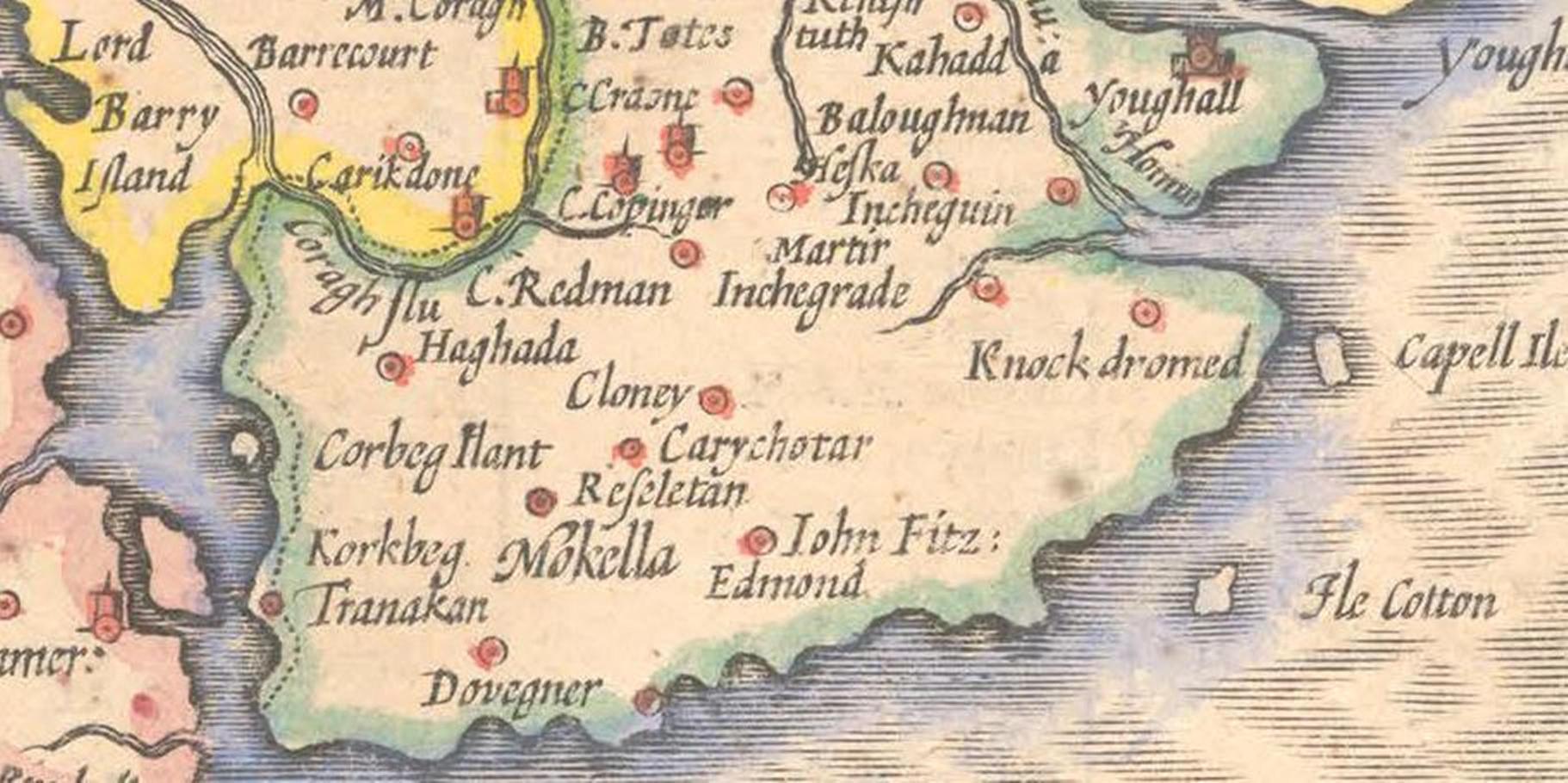
John Speed’s map of c.1610, part his collection of maps of Britain and Ireland from The Theatre of the Empire of Great Britaine (1611-12), showcases clusters of settlements to the east of Cork harbour extending into West Waterford. All in time were influenced by the age of Richard Boyle (1566-1643), the first Earl of Cork and his clustering of people, industrial manufacture and new cultural practices – all of which were ‘planted’ or sown as such into the East Cork and West Waterford landscape. Boyle inherited a highly politicised landscape, which just a few years previously new plantation structures emerged across – old ways, old stories, old politics was dismantled and attempted to be disentangled, and new ways of integration and colonisation were born.This is a landscape which just a few years previously had seen its landowner beheaded – Gerald Fitzgerald – and its successor Walter Raleigh go bankrupt.
Speed’s map of East Cork illustrates the former lands and key settlements of the Fitzgeralds who were earls of Desmond and who were one of the most powerful families in Munster. Several of them were lords deputies of Ireland in the fourteenth and fifteenth centuries. Gerald Fitzgerald, sixteenth earl of Desmond, resisted the Reformation in the reign of Elizabeth, and waged war against the English government. The Earl of Desmond’s forces after long contests were defeated, and he himself was slain in a glen near Castle Island, in county Kerry, on 11 November, 1583. His head was cut off and sent to England, by Thomas Butler, Earl of Ormond, as a present to Queen Elizabeth, who fixed it upon London Bridge.
On Speed’s map a number of sites are shown associated with members of the Fitzgerald family who had retained their lands due to tenancy deals struck with the monarchy and local lords such as Boyle. Corkbeg island plantation is shown. In time these lands passed down through the Fitzgerald family and Corkbeg House, the elegant residence of R. U. Penrose Fitzgerald, was created. The lawn and shrubbery were connected by a narrow slip with the main land, where the remainder of the demesne, comprising 350 acres of some of the best cultivated land in the barony was situated. The island and demense was built over by Whitegate Oil refinery in the late 1950s.
The name FitzEdmund near Cloyne is marked or that of John FitzEdmond FitzGerald. He was an MP for Cork County in 1585. He was son of Sir Edmond Fitzgerald, knight, of Cloyne, who was descended from the Knights of Kerry. He lived at Ballymaloe in a tower house; part of the fifteenth century structure still stands. He was sheriff of the county in 1570. On 16 May, 1582, he had a pension of 100 marks per annum granted to him. For his allegiance and his neutrality during the plantations wars with other cousins of the Fitzgerald clan, and neutrality within the Battle of Kinsale he was knighted 11 March, 1601-2, by Lord Mountjoy, the lord deputy, “whom he entertained at his castle at Cloyne. He died at Cloyne on 15 January, 1612, aged 85. A stone commemorating the event and bearing the Fitzgerald coat of arms is set into the back wall of the present house at Ballymaloe.
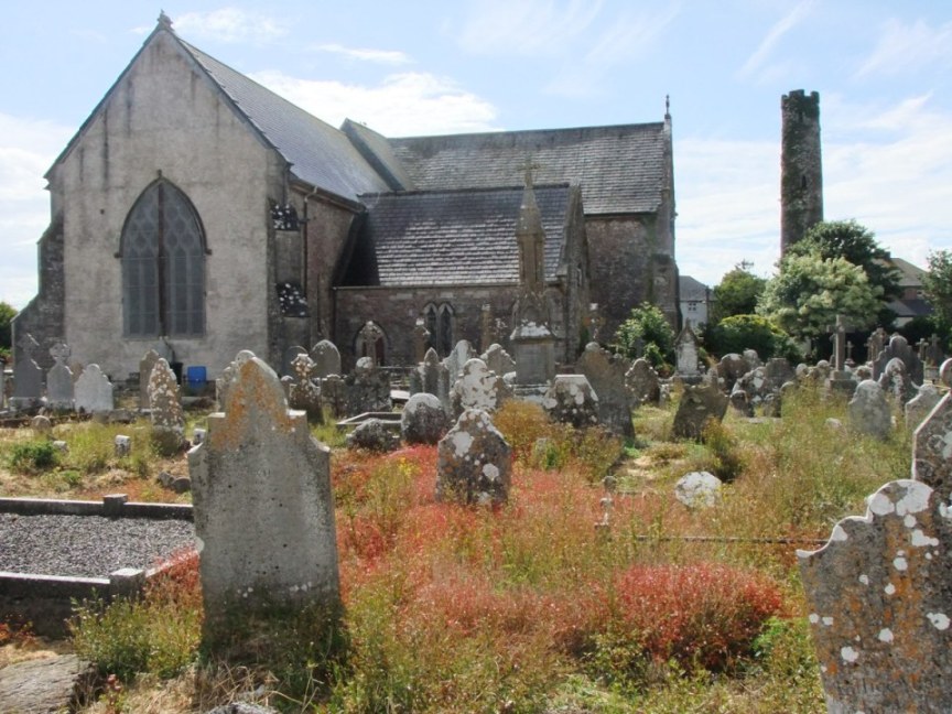
As for Cloyne it is marked as Cloney. The Diocese of Cloyne has its beginnings in the monastic settlement of St Colman at Cloyne in East Cork. A round tower and pre-reformation Cathedral still stand at this site. Cloyne was later to become the centre of an extensive diocese in Munster. For eight centuries it was the residence of the Bishops of Cloyne and the setting for the Cathedral.
A settlement called Tranakan is marked on the map, where now Trabolgan is situated. I have not managed to find information on Tranakan. However around 1640-1650 AD, the Roche family purchased this part of the Fitzgerald estate from Edmund Fitzgerald of Ballymaloe and lived for many centuries at Trabolgan.
To the north of the eastern harbour area, the town of Midleton had not been created yet (it was incorporated by charter in 1670). In the 1180s the Anglo Normans led by the family Barry Fitzgerald founded an abbey at a weir on the nearby river to be settled by Cistercian Monks. The abbey became known as “Chore Abbey” and “Castrum Chor”, taking its name from the Irish word cora (weir). The abbey is remembered in the Irish name for Midleton, Mainistir na Corann and in the Owenacurra or Abhainn na Cora meaning River of the Weirs. The name Coragh Flu is marked on Speed’s map. To the east of this denotation, the site of Castle Redmond built by Redmond Fitzgerald or FitzEdmund in the reign of Henry VIII is denoted. Coppingerstown Castle, another Fitzgerald castle, is also shown (survives in ruins). The lands were formerly that of the Coppinger family who were originally of Danish stock and who for many generations were important in the Danish sector of Cork and County.
To be continued…
Captions:
817a. Eastern section of Cork harbour from John Speed’s Province of Munster, from his The Theatre of the Empire of Great Britaine, c.1610-11 (source: Cork City Library)
817b. St Colman’s Cathedral, Cloyne, Round Tower and graveyard, formerly the centre of an extensive diocese in Munster, present day (picture: Kieran McCarthy)