To ask the CE for an update on the planning status around the historic Bonded House Warehouses, which are now in a very poor state (Cllr Kieran McCarthy)
Motions:
That further slowing down measures be pursued in order to slow down traffic from Ashton School to Crab Lane on Blackrock Road and to investigate the possible introduction of pedestrian crossing at Crab Lane to cross over to the northern footpath of Blackrock Road (Cllr Kieran McCarthy)
That the City Council liase with Cork Sports Partnership and roll out the Water Safety flag award in Cork City Schools (Cllr Kieran McCarthy)
That a comprehensive river use feasibility study be carried out prior to any further development of the Cork Luas across the river (Cllr Kieran McCarthy)
That the former ESB Caroline Street Sub station be once again be investigated as a potential artist hub in the city centre (Cllr Kieran McCarthy)
Independent Cllr Kieran McCarthy invites all Cork young people to participate in the fifteenth year of McCarthy’s Make a Model Boat Project. All interested participants must design and make a model boat at home and bring it to The Lough on the evening of Thursday 22 May 2025.
The event is being run in association with Meitheal Mara and the Cork Harbour Festival Team for the Cork Harbour Festival itself. There are three categories, two for primary and one for secondary students. The theme is ‘Boats from your imagination, which is open to interpretation. The model must be creative though, made from recycled materials and must be able to float. There are prizes for best models and the event is free to enter. For further information and to register a boat, log onto http://www.corkharbourfestival.com
Cllr McCarthy, who is heading up the event, noted: “Over the 15 years of this annual project, the Make a Model Boat Project has gone from strength to strength. The Cork Harbour festival team and I have seen really creative entries and of course it is great to be able to float boats on a fantastic amenity such as The Lough. I am encouraging creation, recycling, innovation and imagination amongst our young people, which are important traits for all of us to develop. The Make a Model Boat Project is part of a suite of community projects I have organised over the years– the others include the Discover Cork: Schools’ Heritage Project with Cork City Council, the Community local history walks, and local history publications”.
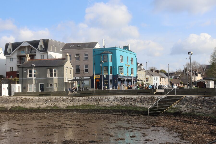
1303a. Blackrock Pier, present day (picture: Kieran McCarthy).
Kieran’s Our City, Our Town Article,
Cork Independent, 8 May 2025
Making an Irish Free State City – The Blackrock Fishing Community Speak Out
Early summer coincides with warmer days to host historical walking tours and also to tie some of the tours to my research around early Irish Free State or Cork in the 1920s. My historical walking tour of Blackrock – coming up again on Saturday 24 May in association with the Cork Harbour Festival – is an opportunity to once again take interested people across the rich historical landscape of Blackrock Village.
Through ongoing research for this column, I came across an article in the Cork Examiner published on 12 January 1925. It provides insights into the fishing community in Blackrock one hundred years ago and their challenges in the early Irish Free State.
A meeting was held at the Recreation. Hall, Blackrock with the object of developing the Lee salmon fisheries, as well as securing financial aid for the net fishermen engaged in such fisheries in order to enable them to procure suitable equipment. There were 32 licensed boats, over 100 fishermen – many of whom has years of experience – and circa 1,000 dependents in the Blackrock area on the local fishing industry. The industry in Blackrock yielded on average £1 per salmon caught and some years over £100,000 salmon could be caught by the Blackrock community. The community at Blackrock was notably up there as one of the largest fishing communities in Ireland.
At the meeting there was a large and representative attendance of net fishermen from Cork and Blackrock present while Mr Michael Egan, TD and representatives of the Cork Harbour Board were also present.
Fr T Murphy, CC, Blackrock, occupied the chair. He noted that it was absolutely necessary that the conditions of the fishermen should be improved; “We are within a few days of the new season and I hope that it will be a better season than last season and prove of great benefit to the fishermen and their families and the whole district”.
Fishing community representative Mr Michael Dorney, highlighted that the Blackrock fishermen suffered severely during the Black and Tans regime; “We were unable to properly follow our political beliefs for the advancement of the national cause, and were faced by distress…The fishermen are entitled to consideration for all they have gone through”. Mr Dorney also complained of the lack of suitable grounds and landing places around Blackrock and urged the necessity of having proper gear and equipment provided for the fishermen.
Another fishing community representative, Mr William J Deasy, said up to eight or nine years previously the industry was in a flourishing condition. Sufficient money was then made during the season by the Lee net fishermen to support their families, even though no other work was available during the close season. Within more recent periods, however, that had not been so, and since 1918 many families had been practically starving during the winter months.
Mr Deasy continued that when British troops and Black and Tans swarmed the country and with the knock-on curfew law they could not ply their craft at night. He noted; “Even when such law was not in operation it was not safe for them to work at night; in fact their boats were commandeered and misused and their nets destroyed, and when the men themselves ventured out for a haul they were fired on”.
Mr Deasy detailed that poaching, poisoning and destruction went on in both upper and lower waters. It was a state of affairs that the Conservators were powerless to effectively deal with owing to the conditions prevailing; “The river became so denuded of fish that from 1920 to 1923 the industry was a hopeless failure. How the fishermen had been able to live at all during the past winter was almost a mystery, because the past season has proved a hopeless one, and then there was no work available during the close season”.
Mr Deasy outlined that in October 1924 an effort was made to revive the oyster fishery, which managed to keep off starvation for that time, but in early 1925 the net fishermen found themselves struggling to afford the high price of material for “gear, twine, ropes, etc”. In addition, Mr Deasy asserted that the boats in use were old and almost unseaworthy and a positive danger in the rough weather to be expected in early spring.
Mr Deasy concluded that previous to the recent by-election the fishermen had heard a good deal about the intentions of the Government to give “paternal care towards fostering their dying industries”. Mr Deasy called for a small grant in aid of the fishing industry and to bring the matter before the Minister for Fisheries.
Mr J Dinneen, representative of the Cork Net Fishermen Association, complained that their nineteen boats had suffered an untold loss by being deprived of their landing place in consequence of the Tivoli reclamation scheme. He noted; “Forty or fifty feet of water had now been made available at that place, and the fishermen had no suitable landing place there…If a high-water fishery were made below Tivoli and another at Barrington’s it would be a great benefit to the Cork and Blackrock fishermen”.
Mr Michael Egan, TD, representing the Cumann na nGaedheal government, responded to the various interventions from the floor saying he could assure them that the matter of fishing was of vital importance to the country. He noted that he would bring the asks of the meeting to the relevant Minister.
Exploring the now digitised Department of Fisheries reports from the late 1920s, it is clear that the challenges of Blackrock fishing community were also seen in other Irish coastal villages and that equipment shortages were met through larger national loan schemes, but these were developed slowly over the ensuing years by the Department due to financial prudence.
Caption:
1303a. Blackrock Pier, present day (picture: Kieran McCarthy).
Next May Walking Tours with Kieran (All free, two hours, no booking required).
Saturday afternoon, 24 May, Stories from Blackrock and Mahon, Historical walking tour of Blackrock Village, from Blackrock Castle to nineteenth century houses and fishing; meet in adjacent carpark at base of Blackrock Castle, 2pm.
Sunday evening,25 May, The Lough and its Curiosities, historical walking tour; meet at green area at northern area of The Lough, entrance of Lough Road to The Lough, Lough Church end; 6.30pm.
Friday evening, 30 May, Cork Through the Ages, An Introduction to the Historical Development of Cork City; meet at the National Monument, Grand Parade, 6.30pm.
Friday evening, 2 May, Cork South Docklands, Historical walking tour, Discover the history of the city’s docks, from quayside stories to the City Park Race Course and Albert Road; meet at Kennedy Park, Victoria Road, 6.30pm.
Saturday afternoon, 3 May, The Northern Ridge, St Patrick’s Hill to MacCurtain Street; Historical walking tour of the area around St Patrick’s Hill – Old Youghal Road to McCurtain Street; meet on the Green at Audley Place, top of St Patrick’s Hill, 2pm.
Saturday afternoon, 24 May, Stories from Blackrock and Mahon, Historical walking tour of Blackrock Village, from Blackrock Castle to Nineteenth Century Houses and Fishing; meet in adjacent carpark at base of Blackrock Castle, 2pm.
Sunday evening, 25 May, The Lough and its Curiosities, historical walking tour; meet at green area at northern green of The Lough, entrance of Lough Road to The Lough, Lough Church end; 6.30pm.
Friday evening, 30 May, Cork Through the Ages, An Introduction to the Historical Development of Cork City; meet at the National Monument, Grand Parade, 6.30pm.
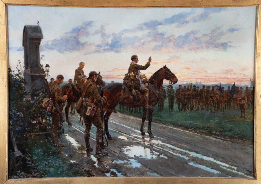
1302a. Picture of the Copy of the painting of The Last Absolution of the Munsters at Rue du Bois at Cork Public Museum, May 2025 (source: Cork Public Museum).
Kieran’s Our City, Our Town Article,
Cork Independent, 1 May 2025
Exhibition on the Last General Absolution of the Munster Fusilliers
A new exhibition to commemorate the centenary of the unveiling of the Cork War Memorial on the South Mall, on 17 March 1925, has opened in Cork Public Museum in Fitzgerald’s Park.The exhibition entitled The Last General Absolution of the Munsters at Rue de Bois can be viewed until 22 May.
The main feature of the exhibition is the earliest known painted copy of the iconic Great War painting, The Last General Absolution of the Munsters at Rue du Bois by Italian artist, Fortunino Matania. Daniel Breen, Curator of Cork Public Museum has noted that Cork Public Museum is “delighted to be able to display this wonderful and historic painting to the public for the first time ever”.
The painting illustrates the 2nd Battalion of Royal Munster Fusiliers receiving general absolution on the eve of the Battle of Aubers Ridge from their chaplain, Father Gleeson adjacent a roadside shrine on the Rue du Bois in France on 8 May 1915. The scene is based on eyewitness accounts gathered by Jessie Rickard, the widow of Lieutenant-Colonel Victor Rickard, who was killed in the battle.
The following day, the British Army lost 11,000 men, dead or wounded, during the Battle of Aubers Ridge, of which 300 came from the 2nd Battalion of the Royal Munster Fusiliers. Of these 300, 95% were Irish, with at least 50 connected to Cork City and County.
Interpretative panels at the museum outline that the painting was published in the British magazine, The Sphere, on 27 November 1916. It was so popular that large numbers of prints were later sold by the magazine. It was also published in the Irish publication, The Weekly Freeman’s. After the war many households in Cork displayed a copy of the print to honour family members who took part in the conflict.
The original painting is believed to have been lost in the bombing of London during the Second World War. However, the version currently on display at Cork Public Museum was particularly commissioned from the artist in 1919 by Alfred Robinson to hail the safe return of his son Lieutenant Alfred Esmond Robinson MC and Bar, from the war. The painting remained with the Robinson family until it was sold at auction last year. Thankfully, it was purchased by Willie and Mary Slattery from Dublin who very generously loaned it to Cork Public Museum for public display.
Interpretation panels on the artist Fortunino Matania outlines that he was a painter, draughtsman and miniaturist who focussed on historical subjects. Born in Naples on 16 April 1881, he studied art with his father, Eduardo Matania, a prominent artist for the Italian weekly, L’Illustrazione. At the age of eleven, he exhibited his first work at the Naples Academy. Three years later, he followed in his father’s footsteps and was employed as an artist by L’Illustrazione.
At the age of twenty, Matania moved to Paris to work with lustration Francaise. Then, in 1904, he moved to London after Clement Shorter, editor of the British illustrated magazine The Sphere, employed him to create illustrations of news events from around the world. His pictures were frequently based on eye-witness accounts and became known for their authenticity and photorealistic quality.
Matania produced some of his most famous work while working at The Sphere, including detailed illustrations of many different events from the Great War. To ensure these pictures had a high degree of accuracy, Matania visited the Front at several times in order to view the circumstances faced by military personnel.
The Museum’s interpretative panels also outline that the painting was stirred by the 1915 book The Story of the Munsters, which was written by Jessie Rickard, a well-known novelist and wife of Colonel Victor Rickard, one of the officers depicted in the painting and who also lost his life during the Battle of Aubers Ridge. Though Dublin-born, Jessie Rickard spent much of her life in Cork.
Jessie was born in Dublin in 1876. She was the daughter of Canon Courtney Moore, Anglican Rector, noted antiquarian and founder of the Cork Historical and Archaeological Society, and his wife, Jessie Mona Duff. She spent most of her youth in Mitchelstown, County Cork. When she was eighteen years old, she penned a series of hunting sketches that appeared in The Cork Examiner. These were followed by a hunting story, The Price of a Friend, which appeared in The Irish Times. In October 1901, Jessie married Robert Dudley Innes Ackland. Though the couple had a daughter in 1902, they divorced in 1907, causing a rift between Jessie and her father. The following year, Jessie married Victor Rickard and in 1913, the couple had a son.
After Victor Rickard was killed at Aubers Ridge Jessie published four articles on the Royal Munster Fusiliers in the journal New Ireland. Her account of the Last General Absolution of the Munsters at Rue du Bois on 8 May 1915, shaped the basis of the painting, which served as a visual memorial to her husband and his men. The articles also appeared in the British magazine, The Sphere, and in her book, The Story of the Munsters at Etreux, Festubert, Rue du Bois and Hulloch, which was published in 1918.
In 1916, Jessie married Lieutenant Colonel Tudor Fitzjohn, but the couple divorced in 1935. During her life she wrote over forty novels which were published under the name Mrs Victor Rickard.
Jessie was received into the Roman Catholic Church in 1925, and in 1946 she came to Cork and resided in Montenotte – home of Denis Gwynn, an old friend and Professor of Modern Irish History at UCC. Jessie Rickard died on 28 January 1963 and is buried in Rathcooney Cemetery in Cork.
The Cork Public Museum exhibition also reflects upon the lives and experiences of some of the men portrayed in the painting, using original object and personal possessions to voice their stories, including that of Private Christy Barry, of Douglas Street, who was present for the last absolution and who also lost his life in the following day’s battle.
May Walking Tours with Kieran (All free, two hours, no booking required).
Friday evening, 2 May, Cork South Docklands, Historical walking tour, Discover the history of the city’s docks, from quayside stories to the City Park Race Course and Albert Road; meet at Kennedy Park, Victoria Road, 6.30pm.
Saturday afternoon, 3 May, The Northern Ridge, St Patrick’s Hill to MacCurtain Street; Historical walking tour of the area around St Patrick’s Hill – Old Youghal Road to McCurtain Street; meet on the Green at Audley Place, top of St Patrick’s Hill, 2pm.
Saturday afternoon, 24 May, Stories from Blackrock and Mahon, Historical walking tour of Blackrock Village, from Blackrock Castle to Nineteenth Century Houses and Fishing; meet in adjacent carpark at base of Blackrock Castle, 2pm.
Sunday evening, 25 May, The Lough and its Curiosities, historical walking tour; meet at green area at northern green of The Lough, entrance of Lough Road to The Lough, Lough Church end; 6.30pm (free, 2 hours, no booking required).
Friday evening, 30 May, Cork Through the Ages, An Introduction to the Historical Development of Cork City; meet at the National Monument, Grand Parade, 6.30pm.
Caption:
1302a. Picture of the Copy of the painting of The Last Absolution of the Munsters at Rue du Bois at Cork Public Museum, May 2025 (source: Cork Public Museum).
Making an Irish Free State City – The Lest We Forget Inscription
On 17 March 1925 at the new Great War Memorial on Cork’s South Mall General Stanish Harrison, who was a former commanding officer of the Royal Munsters, having formerly served with the King’s Liverpool Regiment, unveiled the memorial. He was extended a very hearty welcome by the Independent Ex-Service Men’s Club who commissioned the memorial.
The Cork Examiner, the following day, after the unveiling outlined the event and the speeches given. General Harrison said he considered it a very great honour to be asked to come to Cork to unveil such a memorial to the comrades whom they had lost. He deemed the event as one of mourning and remembrance to those who sacrificed their lives;
“Their comrades had shown them the road – God bless them and God bless all those whom they had left behind and bring them happiness in the present life until the time came for them to join their former comrades. The monument was erected to the memories of some one thousand men, though that was not anything like the number of men who made the supreme sacrifice from the county of Cork. It was a very worthy monument, and I have great pleasure in unveiling it”.
General Harrison availed of the occasion to ask the Government of the country to see their way to help the families of those who had fallen and also to help many of whom who had connections to the war and who were now poor and hungry. He commented; “They deserve every help that the Government could give them, and I feel sure that such help would be forthcoming. God save the King and God save Ireland”.
At this stage General Harrison drew the Union Jack from the monument and the memorial was unveiled to the sounding of the Reveille by a party of massed buglers, directed by bands master Mr Deane of the Greenmount Industrial School Band.
Deputy Michael Egan TD, a Cumann na nGaedheal or government representative, then addressed the gathering and said it was his proud privilege to be associated with the ceremony of the unveiling of that beautiful monument to the men who went out and fought and died so that their fellow countrymen and women could live in peace. He noted his support of the unveiling; “I am glad to be associated with the body of men who came together and showed they had not forgotten their fallen comrades by erecting that memorial to their memory. It had for its motto appropriate words, Lest We Forget, because it was their duty not to forget the brave deeds of the men who went out and died on behalf of the small nations of the world”.
Deputy Egan continued that when a question was raised in connection with the erection of the monument some friends and himself stepped up because they saw no reason why Irishmen who died abroad could not be remembered by the people whom they served, and a memorial put up to their memory in their native city. He called upon the Irish Free State government to pursue their duty to see that the men who went out and fought, as well as the dependents of those who fell in the fight should be well catered for, and not be allowed to go into poverty and distress; “As far as I am concerned it is my duty to assist in every way in seeing that they would be well looked after…I promise that whatever I can do on their behalf would be readily done”.
Cllr John Horgan said he was also delighted at the opportunity afforded him by the invitation of the ex-servicemen of being present and to speak at the unveiling of such a beautiful monument to the men, who in his opinion, did as much as any people in Ireland in order that the people of the country might be free. He continued; “They have contributed very largely to the measure of freedom that their country had obtained…I remember well when the rallying cry for the freedom of small nations rang out, how the men of Cork responded in order to achieve such an object, and particularly to prove the right of their own land to win its liberty. They fought on many fronts and willingly gave their lives for freedom that they believed every small nation was entitled to, and it was only fitting that their memories should be properly honoured. When application for the erection of that memorial was made to the Corporation I supported it, because I believed at the time that it was only fitting that a suitable memorial should be erected to such men in their native city”.
Cllr Horgan continued that the monument’s motto “Lest We Forget” typified friendship and comradeship of their fallen comrades, colleagues and proved that the memory of those who fell would always remain with them. He deemed that the “silent monument was a standing tribute of the affection of those who were left behind” and that they were all delighted at that opportunity of honouring the memory of their fallen comrades.
Fr Scannell then spoke. He commented that he was also delighted to be associated with the function and reflected upon the Lest We Forget inscribing; and the sacrifice and patriotism; “The monument bears the inscription ’Lest We Forget’. We cannot forget. I will never forget, and neither will any man who was out in France and on the other fronts with the Irish troops. We will never forget the bravery of the Irish soldiers who fought and died and the edification they gave to all who came in contact with them. We will never forget their edification in patriotism, and their sanctity in life and death. That religious edification, and patriotism should always be remembered for the Irish troops, and, therefore, it was fitting that such a monument should be erected”.
In addition Fr Scannell congratulated them on selecting that day, the feast of Ireland’s Patron Saint, St Patrick, for the unveiling of the monument, as it was, in his opinion, “a fitting day for such a ceremony”.
Next April Historical Walking Tours with Kieran, All tours free, 2 hours, no booking required
Saturday 26 April, The Cork City Workhouse Tour; learn about Cork City’s workhouse created for 2,000 impoverished people in 1841; meet just inside the gates of St Finbarr’s Hospital, Douglas Road, 1pm.
Sunday 27 April, Fitzgerald’s Park: The People’s Park Tour, from stories on the Mardyke to the Cork International Exhibition, meet at the band stand, 1pm.
Caption:
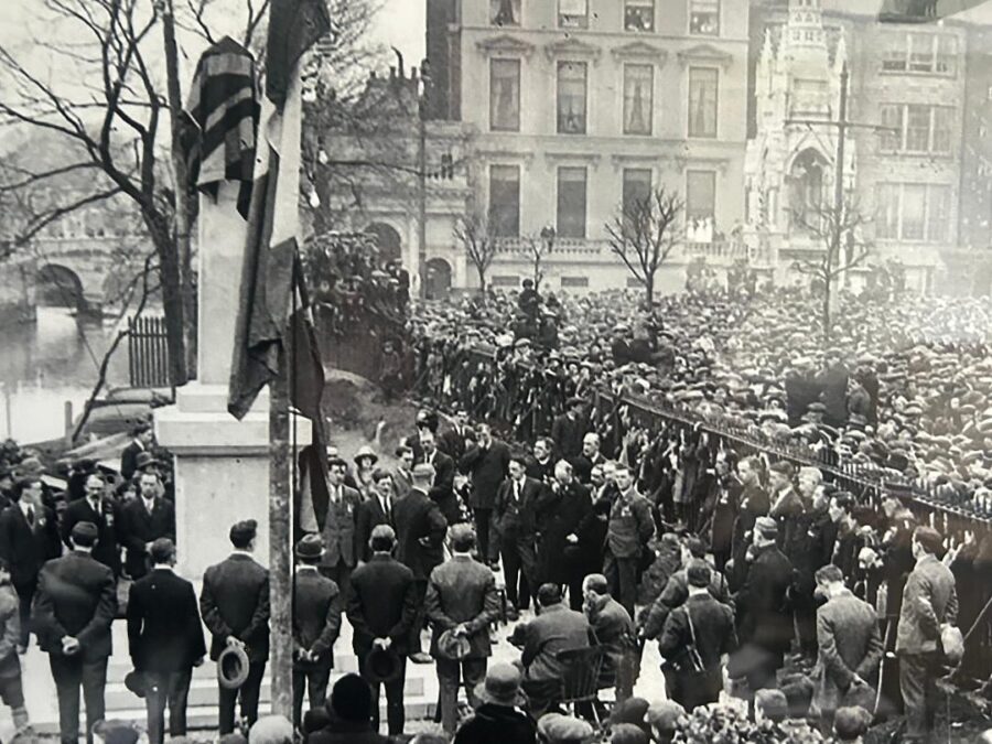
1301a. Unveiling the Great War Memorial, South Mall, 17 March 1925 (source: Cork Public Museum).
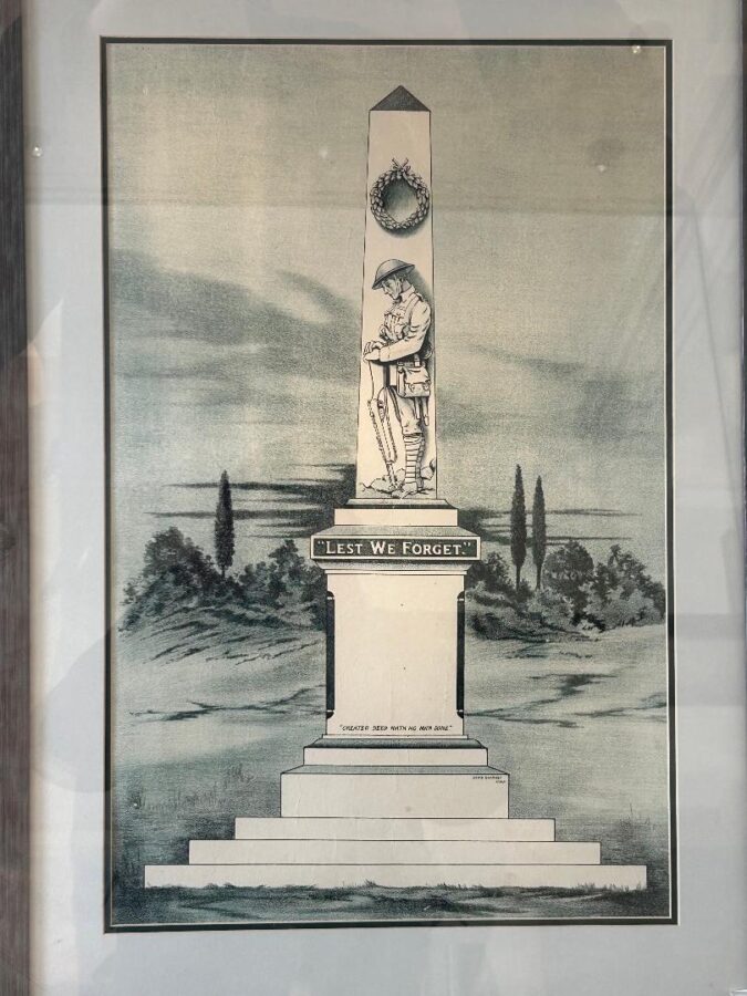
1300a. Denis Sharkey’s original sketch for the First World Memorial, South Mall, c.1924 (source: Francis O’Connor & Cork Public Museum).
Kieran’s Our City, Our Town Article,
Cork Independent, 17 April 2025
Making an Irish Free State City – Unveiling the Great War Memorial
In the winter of 1924 to the spring of 1925 fundraising for the Great War memorial on Cork’s South Mall continued at pace. A design was also chosen by the Cork Independent Ex-Servicemen Club. Denis Sharkey, a Cork sculptor, was chosen. An Irish Examiner advertisement on 16 April 1898 denotes that Denis had just taken over his father’s business. The D Sharkey Marble and Monumental Works was originally based at High Street and then moved 102 Douglas Street. An advertisement for Denis on 17 April 1912 locates him at Blackpool Bridge and details that the business made crosses, headstones, chase and original designs.
A delay in the quarrying of stone at Ballinasloe in County Galway for the Great War memorial meant that the original plan for a November 1924 unveiling was missed. In a meeting of the Cork War Memorial Committee in early March 1925, committee member Mr P Byrne noted that it was great pity that they had to disappoint the public on Armistice Day. He outlined that the quarries in Ballinasloe were flooded due to heavy storms. However, since they received the stone, good progress had been made by the contractor on the execution of the work. Mr Byrne continues that he had been interviewed by several relatives of the fallen with reference to their names being inscribed on the stone. He noted that the charge for inscription was very reasonable and he hoped that many more would avail of the opportunity to have the names of their relatives inscribed on the monument.
Mr T O’Neill highlighted that there was no doubt that great credit was due to the committee in general. It was their first attempt in organising such a large project. He hoped that their Flag Day on 14 March 1925, which was entitled “Forget Me Not Day” would be generously supported.
On 17 March 1925, the unveiling of the Great War memorial took place at the South Mall, the ceremony being performed by General Standish Harrison, late commanding officer of Royal Munster Fusiliers’ Depot, who took the salute from the foot of the memorial. Many thousands of ex-servicemen, and widows and orphans of the men in whose honour the memorial was erected, were present at the ceremony.
The Cork Examiner describes that the day’s programme was an elaborate one and opened with parades of ex-Servicemen at eleven o’clock. The two organisations in Cork – the Cork Independent Ex-Servicemen and the Cork branch of the British Legion – participated. They were led by General Harrison and members of the Executive Committee of both parties, marched to the Cathedral, where they attended High Mass.
The High Mass at the North Cathedral was celebrated by Bishop Cohalan. A large number of the city’s clergy were present. There was an immense congregation in the church composed chiefly of those taking part in the subsequent procession and unveiling ceremony. At the conclusion of the Mass the Roman Catholic party was joined by the Protestant party, who had formed up on St Mary’s Road, and the procession to the South Mall then commenced.
The Cork Examiner describes that the procession included several thousand ex-servicemen wearing their military decorations and led by their old officers, a large number of ladies bearing beautiful wreaths, relatives of the fallen men, many children wearing the medals of their dead fathers, and a big number of the general public. Six bands were in attendance – these being the Independent Ex-servicemen’s Band, the Legion Band, the Parnell Guards, the Barrack Street Band, the Greenmount Industrial School Band, and the Lee Pipers’ Band.
Fr Scannell – also wearing his military decorations – walked at the head of the members of the Cork branch of the British Legion. Immediately preceding these in the procession was General Harrison’s carriage, in which were the General and Gerald Byrne, chairman of the Cork Independent Ex-servicemen, J R Connolly, chairman of the Cork branch of the British Legion, and J Lee, secretary of the War Memorial Committee.
The procession route followed was via Shandon Street and Pope’s Quay to Bridge Street, and then by MacCurtain Street, Brian Born Bridge, Merchant’s Quay, St Patrick’s Street, and the Grand Parade, to the Memorial at the western end of the South Mall. Thousands lined the streets through which the procession passed.
When the memorial was reached at 2.15pm, the executives of both organisations formed up on three sides of a square surrounding the baseof themonument, while relatives of the fallen men and public representatives were accommodated inside the railings of the little park in which the memorial stands.
Under the direction of Bandmaster Mr Deane, Greenmount Industrial School Band, buglers drawn from both of the ex-servicemen’s organisations sounded the Last Post, and immediately afterwards the ceremonies associated with the unveiling commenced.
The Chairman, Gerald Byrne, said there were assembled to unveil a monument to their comrades who fell on the different fronts fighting for the freedom of small nations. He desired to thank, on behalf of the Cork Independent Ex-Service Men, General Harrison for coming to the city to unveil the memorial. He also thanked for their attendance, Mr Michael Egan, Mr John Horgan and Mr D F Doyle, who had been their friends throughout the period of the erection of the monument, and in addition to Fr Scannell who was at their service at all times.
Caption:
1300a. Denis Sharkey’s original sketch for the First World Memorial, South Mall, c.1924 (source: Francis O’Connor & Cork Public Museum).
Next April Historical Walking Tours with Kieran, All tours free, 2 hours, no booking required
Saturday 26 April, The Cork City Workhouse Tour; learn about Cork City’s workhouse created for 2,000 impoverished people in 1841; meet just inside the gates of St Finbarr’s Hospital, Douglas Road, 1pm.
Sunday 27 April, Fitzgerald’s Park: The People’s Park Tour, from stories on the Mardyke to the Cork International Exhibition, meet at the band stand, 1pm.
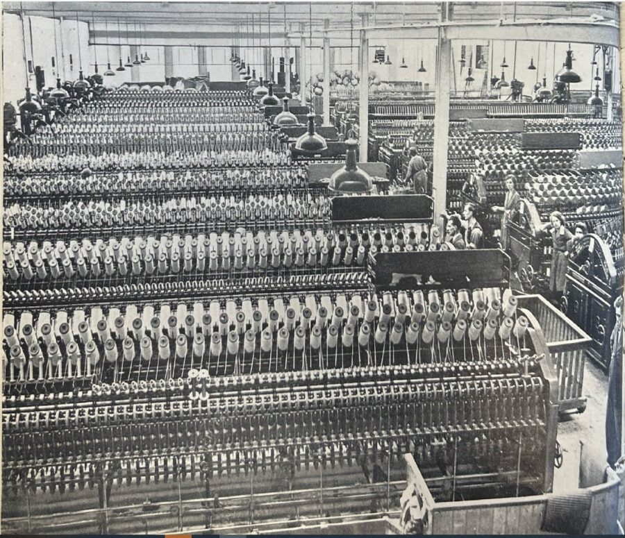
1279a. Worsted spinning plant of fast-spinning reels and flying threads at Sunbeam Wolsey Ltd, Blackpool, 1942 (source: Cork City Library).
Kieran’s Our City, Our Town Article,
Cork Independent, 14 November 2024
Making an Irish Free State City – Further Growth for Sunbeam Wolsey
By the end of 1934 the Sunbeam Wolsey Partnership was doing well economically and striving into its future plans. The newly formed Company had been trading officially since the January 1934, with the benefit of the agreement with Wolsey Limited, Leicester, UK. The core Director, William Dwyer was concentrating on the development and manufacture of a complete range of hosiery and knitwear products. The Irish Press newspaper records on 7 December 1934 that new plant machinery from Germany had been installed for the manufacture of silk stockings and was capable of producing stockings of all types for the Irish market. The Company now employed a staff of nearly 600 as compared with 150 in December 1932.
For the year ended 30 June 1934, the trade exceeded the combined trade of Sunbeam Knitwear, Limited, and the Irish Free State trade of Wolsey Limited by approximately 25% as compared with the previous year. For the period from 1 July 1934 to 31 October 1934. the total trade of the Company showed a still further increase, being approximately 50 per cent greater than that of the corresponding period in 1933. The growth continued right throughout 1935 and 1936.
On 26 August 1936, the Irish Independent outlined the profits accrued in the Sunbeam Wolsey annual report, but also the core challenge of staff pay facing the Company. In particular William Dwyer outlined that there was an absence of a standard rate of pay for operatives in the industry. He drew on the returns of the Department of Industry and Commerce that cast a focus on the general conditions existing in the hosiery trade. There were three thousand workers in the trade, who were employed by sixty-live manufacturers. Six hundred of these were employed by Sunbeam Wolsey. The average pay of the workers in the sixty-four other factories was £40 per annum. The average earning of Sunbeam Wolsey was £60 per annum.
William Dwyer noted of the pay and the associated challenge of keeping it: “We pay 50 per cent, more than the average wage. The extra cost to us is £14,000 a year. Because of the number of factories, which have now started, the competition, which we are up against is practically altogether internal. That we can meet this competition and still pay 50 per cent higher wages to our workers is a clear at proof that our organisation is on the soundest possible basis”.
On 18 August 1937, A jump of over £8,400 in trading profits was shown in the report of Sunbeam Wolsey – the year ended for 30 June 1937 was £28,260 compared with £19,789 in June 1936.
The eleventh Ordinary General meeting of Sunbeam Wolsey, Limited, was held on 28 August 1939. Here, William Dwyer spoke about having bought outright the factory premises at Blackpool and having just completed the purchase of a new warehouse in Dublin.
William also reflected on the effects of the London Agreement or the ceasing of the Economic War with the UK on the hosiery manufacturing trade in the Irish Free State. He outlined that the duty on wool socks and stockings had been reduced, in some cases by two-thirds, and the duty on underwear had been likewise heavily reduced. Imports of wool hose had risen by approximately 80,000 dozens and of wool underwear by approximately 6,000 dozens, representing increases of over 200 per cent and 40 per cent respectively.
William noted on the increased productivity; “I think that the comparison between our figures and imports this year goes conclusively to prove our claim that we produce goods equal in value and finish to any English goods. The demand for our fully fashioned silk hosiery has made it necessary for as nearly to double our plant. Some of our new machines are now in production and the full plant should be running within two months”.
A year later at the twelfth Ordinary General Meeting of Sunbeam Wolsey Limited on 30 August 1940, William delivered his annual report in the context of the Second World War emerging. When the war broke out the Directors decided that every order on the Company’s books would be executed at the price at which the goods were sold to customers. It was planned that every endeavour was to be utilised to sell the products of the Company at a reasonable price as possible. William on this decision noted; “Even though costs of raw materials were soaring daily and advantage could easily had been taken for large price increases, we feel that the trade in general have appreciated this fact and that during the past year the goodwill of the trade to the Company has increased more than ever before”.
William continued his report commenting on the reduced overhead charges; “All the finished goods in your factory have already been sold for delivery within the next couple of months. Our stocks have been valued in the most conservative way possible. The prices of our goods to-day are very much lower than the price of similar goods sold in England. This is due to the very considerable decrease in the percentage of our overhead charges”.
William also commented that during the 1939-1940 year a subsidiary company called the Cork Spinning Company had created. Its aim was to supply practically all the requirements of the hosiery mill for worsted yarns at a very much lower price than that existing elsewhere. In addition to this the Cork Spinning Company installed a plant lor the throwing of pure silk. This branch of the business was started without any protective duties.
To be continued…
Caption:
1279a. Worsted spinning plant of fast-spinning reels and flying threads at Sunbeam Wolsey Ltd, Blackpool, 1942 (source: Cork City Library).
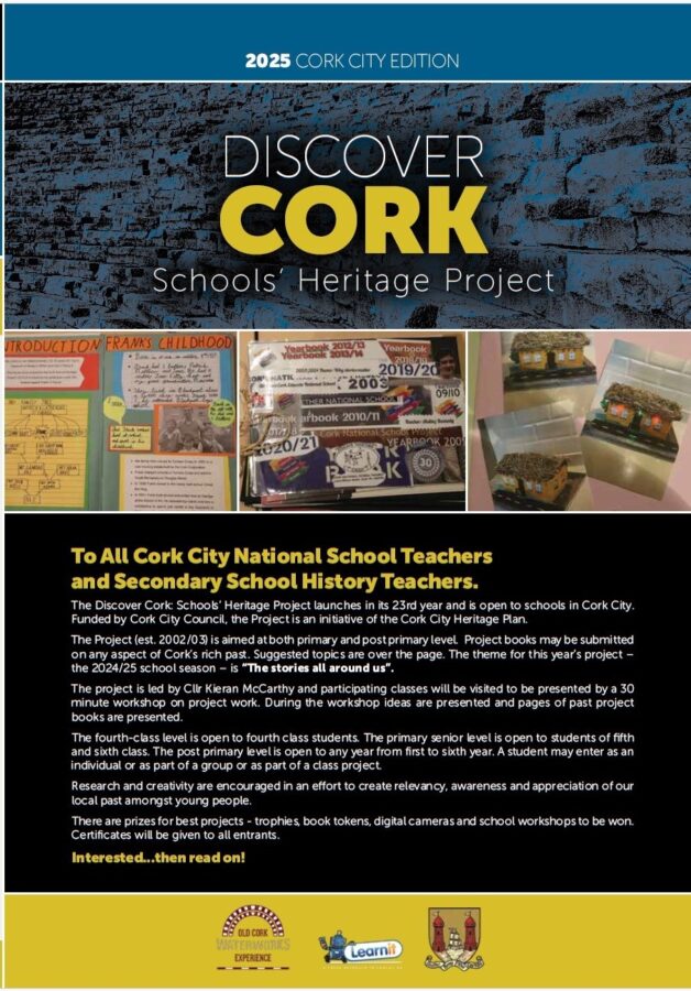
1269a. Front cover of brochure for the Discover Cork Schools Heritage Project 2024-25 school season.
Kieran’s Our City, Our Town Article,
Cork Independent, 5 September 2024
Launch of Discover Cork: Schools’ Heritage Project, Year 23
It is great to reach year 23 of the Discover Cork: Schools’ Heritage Project. It is just slightly younger than this column but both this column, the schools’ heritage project and the walking tours are all about making Cork and its multitude of local histories more accessible to interested citizens and to empower the next generation to be the next guardians of such a heritage.
Over 17,000 students have participated in the Schools’ Heritage Project through the years with many topics researched and written about – from buildings and monuments to people’s oral histories.
Never before has our locality and its heritage being so important for recreation and for our peace of mind. In the past four years, more focus than ever before has been put on places and spaces we know, appreciate, and attain personal comfort from.
The Schools’ Heritage Project is aimed at both primary and post primary level. Project books may be submitted on any aspect of Cork’s rich past. The theme for this year’s project is “The Stories All Around Us”. Funded by Cork City Council, the Project is an initiative of the Cork City Heritage Plan.
The Project is open to schools in Cork City at primary level to the pupils of fourth, fifth and sixth class and at post-primary from first to sixth years. There are two sub categories within the post primary section, Junior Certificate and Leaving Certificate. The project is free to enter. A student may enter as an individual or as part of a group or a part of a class entry.
Co-ordinated by myself, one of the core aims of the Project is to encourage students to explore, investigate and debate their local heritage (built, archaeological, cultural and natural) in a constructive, active and fun way. Projects on any aspect of Cork’s rich heritage can be submitted to an adjudication panel. Prizes are awarded for best projects and certificates are given to each participant. A cross-section of projects submitted from the last school season can be gleamed from links on my website, www.corkheritage.ie where there are other resources, former titles and winners as well as entry information.
Students produce a project book on their local area using primary and secondary sources. The workshop comprises a guide to how to put a project together. Project material must be gathered in an A4/ A3 size Project book. The project may be as large as the student wishes but minimum 20 pages (text + pictures + sketches).
Projects must also meet five elements. Projects must be colourful, creative, have personal opinion, imagination and gain publicity before submission. These elements form the basis of a student friendly narrative analysis approach where the student explores their project topic in an interactive and task-oriented way. In particular, students are encouraged (whilst respecting social distancing) to attain material through visiting local libraries, engaging with fieldwork, making models, photographing, cartoon creating, and making short snippet films of their area. Re-enacting can also be a feature of several projects.
The project is open to many directions of delivery. Students are encouraged to engage with their topic in order to make sense of it, understand and work with it. Students continue to experiment with the overall design and plan of their work. For example, and in general, students who have entered before might engage with the attaining of primary information through oral histories. The methodologies that the students create provide interesting ways to approach the study of local heritage.
Students are asked to choose one of two extra methods (apart from a booklet) to represent their work. The first option is making a model whilst the second option is making a short film. It is great to see students using modern up todate technology to present their findings. This works in broadening their view of approaching their project.
For over 22 years, the project has evolved in exploring how students pursue local history and how to make it relevant in society. The project attempts to provide the student with a hands-on and interactive activity that is all about learning not only about heritage in your local area (in all its forms) but also about the process of learning by participating students.
The project is also about thinking about, understanding, appreciating and making relevant in today’s society the role of our heritage, our landmarks, our oral histories, our environment in our modern world for upcoming citizens. So, the project is about splicing together activity on issues of local history and heritage such as thinking, exploring, observing, discovering, researching, uncovering, revealing, interpreting, and resolving.
This project is kindly funded by Cork City Council (viz the help of Niamh Twomey, Heritage Officer), Administration support and prizes are also provided by the Old Cork Waterworks Experience, Lee Road.
Overall, the Schools’ Heritage Project for the past 22 years has attempted to build a new concerned generation of Cork people, pushing them forward, growing their self-development empowering them to connect to their world and their local heritage. Spread the word please with local schools. Details can be found on my dedicated Cork heritage website, www.corkheritage.ie.
Caption:
1269a. Front cover of brochure for the Discover Cork Schools Heritage Project 2024-25 school season.
Kieran’s Upcoming September Tours (end of season), all free, 2 hours, no booking required:
Sunday 8 September, Blackpool: Its History and Heritage; meet at square on St Mary’s Road, opp North Cathedral, 2pm.
Saturday 14 September, Cork South Docklands; meet at Kennedy Park, Victoria Road, 2pm.
Saturday 21 September, Fitzgerald’s Park: The People’s Park, meet at the park band stand, 2pm.
Sunday 22 September, Stories from Blackrock and Mahon, meet in adjacent carpark at base of Blackrock Castle, 2pm.