Category Archives: Landscapes

Kieran’s Our City, Our Town, 6 August 2015

804a. Map of Cork, late sixteenth century as depicted in Sir George Carew’s Pacata Hibernia


Kieran’s Our City, Our Town Article, 

Cork Independent, 6 August 2015

Cork Harbour Memories (Part 30)

Colonising a Swamp


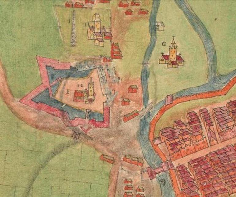
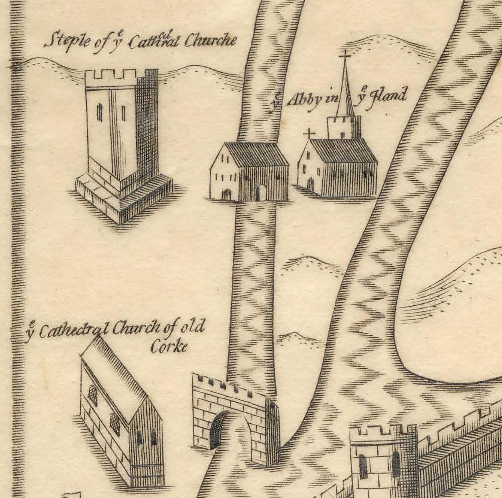
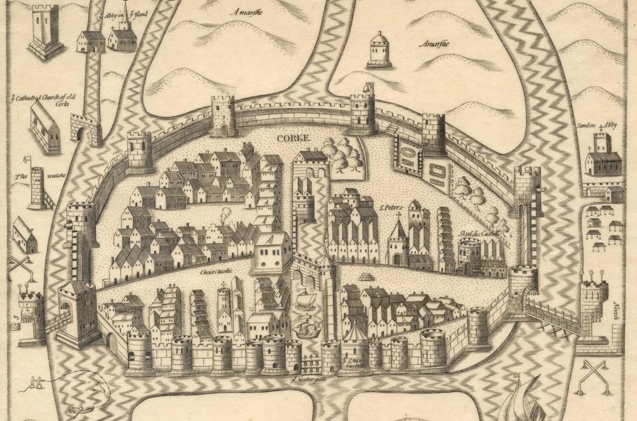
    President of the Munster Plantation George Carew’s Map of Cork circa 1600 shows the town wall of Cork encompassing an oval shaped settlement on a swamp. His emphasis is on showing off the infrastructure. He depicts the town as a spacious, strong and prominent settlement, complete with the protection of drawbridges and the eastern portcullis gate called Watergate. The mechanics of raising up of such structures must have got damp and noisy, must have creaked, and must have irked the visitors to the town. Maybe many of the citizens didn’t hear those sounds, being so used to them. The town was there for several centuries. Access was through these points and people were used to their everyday function in giving and refusing access to the town.

    The walled defences, 1,500 metres in circumference, were to provide security for its inhabitants up to 1690. They also controlled light and shade, the wall overlooked and in a sense organised the lives of citizens. On the map, the buttress walls and its drawn lines that rise from the marshy ground give the structure a striking strength and depth of foundation, physically, spatially and culturally. The hardness and indestructibility of the stone has a noble look to it and fitted Carew’s idea and vision of a colonised landscape. Much of the town wall survives beneath the modern street surface and in some places has been incorporated into existing buildings. Carew presents a wall on his map almost mass concrete looking – as in he doesn’t show the reality of the use of multiple stones in its construction– as seen in the wall on display in Bishop Lucey Park. The wall comprised two stone types, limestone and sandstone,. The engineering involved in its construction was substantial. The citizens must have had problems in laying foundations into the swamp. Their timber scaffolding must have collapsed at times. The courses of the stone must have collapsed. It was a jig-saw puzzle in its construction.

     In a present day context, echoes of the ground plan of the walled town survive. If one starts on the corner of the Grand Parade and the South Mall, on the city library side, the walls of the medieval town would have extended the full length of the Grand Parade, along Cornmarket Street, onto the Coal Quay, up Kyrl’s Quay to the North Gate Bridge. From here they would have extended up Batchelor’s Quay as far as Grattan Street, then turning southwards, the walls would have followed the full length of present day Grattan Street as far as present day Clarke’s Bridge. The walls then followed the course of the River Lee back to the starting point.

     Some of the wealthier merchants formed the corporation and lived in tower houses or large two to three storey castle-like structures. They were as important as the infrastructure and many were the key agents of governance for centuries. These families included the Roches, Skiddys, Galways, Coppingers, Meades, Goulds, Tirrys, Sarfields, and the Morroghs. Their names were all involved in the running of the town from its inception in the late 1100s to the seventeenth century. They also controlled large portions of Cork’s trade and rented out numerous plots of land to other citizens – Irish natives and English colonialists. Carew’s depiction shows two tower houses within the precincts of the medieval core, Skiddy’s Castle and Roche’s Castle. Skiddy’s Castle was located in the north east sector of the town over-looking North Main Street, close to North Gate Drawbridge while Roches Castle was located at the eastern end of middle bridge, the structure that connected the enclosed medieval islands together.

    Carew also places emphasis on other public buildings in this walled town. The corporation of the town conducted public business in the south west quadrant of the walled town or to the west of South Main Street. The council tower, armoury, the town’s court house, the commandant’s house and the treasury were all in this location. In the south west quadrant of the town, the town post office was located, evidenced from present day Post Office Lane situated today adjacent to the Grand Parade. In addition, Christ Church existed in this section, which was rebuilt in 1720. The merchant’s hall was also present in this area and at the western end of Middle Bridge on the southern island side was the location of the custom house or Exchange. All ships docking at the quay inside the town had to report their goods to this building. In the north west section of the town or to the west of North Main Street, a garrison was located for soldiers just south of Skiddy’s Castle. The governor’s house was situated in this area along with St. Peter’s Church, which has taken the form of the Cork Vision Centre. The other main feature in the north west section was the market square from which the town crier shouted and communicated to the population of the town. Carew only depicts two citizens in a boat fishing near South Gate Bridge. But for every house shown in the town, families lived their lives and made the walled town of Cork their home.

 To be continued….


 Captions:

 804a. Section Map of Cork, late sixteenth century as depicted in Sir George Carew’s Pacata Hibernia, or History of The Wars in Ireland (1633), vol. 2, opp page 137.

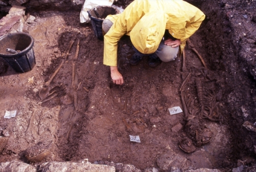
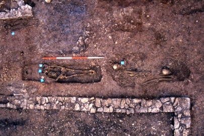
804b. One of the recent Medieval re-enactment days in Bishop Lucey Park (picture: Kieran McCarthy)

 804b. One of the recent Medieval re-enactment days in Bishop Lucey Park


Kieran’s Our City, Our Town, 30 July 2015

803a. Excavating skeletons at Crosses Green, 1993

Kieran’s Our City, Our Town Article,

Cork Independent, 30 July 2015

Cork Harbour Memories (Part 29)

Skeletons beneath our Feet


    Previously, we discussed the Dominican Abbey at what is now Crosses Green. Exciting finds were unearthed in 1993 during the placing of foundations for the Crosses Green Apartment Complex. Excavated remains of buildings were discovered associated with the abbey especially the church, cloister or central walking area and other attached domestic buildings. Among these buildings, many medieval objects were found as well as one of the most preserved graveyards ever found in post medieval archaeological studies. All were studied under the watchful eye at the time of former City Archaeologist, Maurice Hurley and Cathy Sheehan (1995, see local studies in the City Library for their insightful excavation report)

    Part of the finds included the remains of medieval pottery. Clare McCutcheon in her section in the excavation report noted that the largest assemblage came from the south-west of France from the Saintonge area and were early thirteenth to fourteenth century in date. In addition, native Cork type pottery was discovered as well as Redcliffe pottery from Bristol.

    Nearly a half a dozen bone and antler artefacts turned up. These included a modified antler tine or an object used in some manufacturing or shaping process of bone or antler. A broken needle associated with medieval weaving was found along with what is described as a type of toggle to hold clothes together. Rosary beads or paternosters were found. Forty-two beads were, all bone in nature. The beads were found in relation with the torso of a skeleton in a grave.

   Metal objects were discovered of which many were bronze in nature. These included several bronze pins, a needle, an ear spoon (from a toilet set or a surgical instrument set), a ring brooch, which would been used to fasten the cloaks of the monks, a buckle, the hand guard of a dagger, a tweezers, and an iron knife blade. Lead objects included nine lead rods, which were part of stylii or writing leads. Only one medieval coin of a medieval date was found, fourteenth to fifteenth century in date. One piece of structural timber was found, which was said to maybe part of a quay front revetment, a bridge, or a scaffolding piece used in the construction of the priory.

   A total of two hundred graves were found. Under the careful excavation of Catyrn Power, the majority of the graves were discovered within the boundaries of buildings especially within the church and cloister area. Since, the abbey was built on a marshy island, there was a lack of acid in the underlining soil which resulted in little deterioration of the bones of skeletons found. All were reburied appropriately and safely. The majority were excellently preserved and therefore most of the graves comprised of intact comprehensible skeletons. Incidently the first graves associated with the Dominican Abbey are recorded as being located in 1804 when a Mr Walker unearthed several stone lined graves. He was building his own distillery at the time chose not to disturb the burials to any great extent.

   Catyrn in her report notes three main types of graves discovered, which give an insight into the social structure around the area of the abbey. These types included shallow unlined graves which the majority of burials consisted of. In a few unlined graves, an unusual burial practice was noted. Small stones known as pillow stones or other skulls were placed on either side of the skull of the main skeleton in order to keep the skull itself from collapsing to one side.

   The second type of grave found on the grounds of the Dominican Abbey was related to the evidence for charred coffins. In England, during the medieval period, charred coffins were utilised so that the decomposition of wood would be deterred. Stone-lined graves with slab capstones also made up a large part of the burials at Crosses Green. Associated with several of these type of graves on top of them were tomb slabs and effigies (carved statues in stone).

   Three-quarters of the individual skeletons were found to be adults – the largest number being aged in their twenties There seemed to be slightly more males than females excavated. The mortality rate was found to be low and through present day research on medieval times, numerous reasons have for this have come to the forefront such as diet and living standards of the time. Poor living conditions in the nearby walled town and the abbey led to breeding grounds for rats and infectious diseases. In the town overcrowding was common in poorly ventilated dwellings with thatched roofs that had a clay floor which was an attraction to rats and fleas. The water supply was always subject to contamination from sewage and rubbish. Household waste was thrown onto the streets and laneways. Even dead animals were left to decay where they fell. Clothing and hair provided shelter from fleas and lice. Life was tough in medieval Cork.

    In the case of the skeletons excavated and analysed at Crosses Green, just less than half were found to have degenerative joint disease or some form of arthritis. In several individual skeletons, nutritional deficiencies, tumours, dental diseases were noted along with infections. All these can be detected due to their changing effect on the shape and strength of the bone.

 Check out Catyrn Power’s excellent blog, https://corkarchaeologist.wordpress.com/

 To be continued…


Captions: 

803a. Excavating skeletons at Crosses Green, 1993 (pictures: Catyrn Power, https://corkarchaeologist.wordpress.com

803b. Excavating skeletons at Crosses Green, 1993 (pictures: Catyrn Power, https://corkarchaeologist.wordpress.com)

 803b. Excavating skeletons at Crosses Green, 1993

Kieran’s National Heritage Week Tours 2015

Monday 24 August 2015 – Tales of the City’s Workhouse, historical walking tour with Cllr Kieran McCarthy, meet at entrance to St Finbarr’s Hospital, Douglas Road, 7pm (free, duration: two hours).


Wednesday 26 August 2015 – From Market Gardens to Architectural Eminence, historical walking tour of Turners Cross and Ballyphehane with Cllr Kieran McCarthy, meet at entrance to Christ the King Church, Turners Cross, 7pm (free, duration: two hours).


Friday 28 August 2015 – Cork’s Elegant Suburb, Historical walking tour of Sunday’s Well with Cllr Kieran McCarthy, meet at St Vincent’s Bridge on the North Mall side, 7pm (free, duration: two hours).


Saturday 29 August – Park Stories, Historical walking tour of Fitzgerald’s Park with Cllr Kieran McCarthy, meet at band stand in park, 2pm (free, duration: two hours)

Kieran’s Our City, Our Town, 23 July 2015

 802a. View of recent Shandon Street Festival 2015

Kieran’s Our City, Our Town Article, 

Cork Independent, 23 July 2015

Shandon and Blackpool Historical Walking Tours


    I have two more summer walking tours coming up – this time the focus is on the Shandon and Blackpool area – Friday evening, 24 July is the Shandon historical walking tour; discover the city’s historical quarter; learn about St Anne’s Church and the development of the butter market and the Shandon Street area; meet at North Gate Bridge, 6.45pm (free, duration: two hours). The second walking tour weaves through Blackpool, Thursday evening 30 July 2015; from Fair Hill to the heart of Blackpool, learn about nineteenth century shambles, schools, convents and industries, meet at the North Mon gates, Gerald Griffin Avenue, 6.45pm (free, duration: two hours).

  The walking tours intertwine from Shandon into Blackpool and Gurranbraher highlighting several centuries of life in these corners of historic Cork from education to housing to politics, to religion, to industry and to social life itself. Tradition is one way to sum up the uniqueness of Shandon Street. Despite being a physical street, one can stroll down (or clamber up), the thoroughfare holds a special place in the hearts of many Corkonians. The legacy of by-gone days is rich. The street was established by the Anglo-Normans as a thoroughfare to give access to North Gate Drawbridge and was originally known as Mallow Lane. Shandon Street locals identify with the special old qualities of the street. Different architectural styles reflect not only the street’s long history but also Cork’s past.

  In the time of the Anglo Normans establishing a fortified walled settlement and a trading centre in Cork around 1200 A.D., North Gate Drawbridge formed one of the three entrances –South Gate and Watergate being the others. North Gate Drawbridge was a wooden structure and was annually subjected to severe winter flooding, being almost destroyed in each instance. In May 1711, agreement was reached by the council of the City that North Gate Bridge be rebuilt in stone in 1712 while in 1713, South Gate Bridge would be replaced with a stone arched structures. The new North and South Gate bridges were designed and built by George Coltsman, a Cork City stone mason/ architect.

  Between 1713 and the early 1800s, the only structural work completed on North Gate Bridge was the repairing and widening of it by the Corporation of Cork. It was in 1831 that they saw that the structure was deteriorating and deemed it unsafe as a river crossing for horses, carts, and coaches. Hence in October 1861, the plans by Cork architect Sir John Benson for a new bridge were accepted. In April 1863, the foundation stone for the new bridge was laid. The new bridge was to be a cast-iron structure with the iron work completed by Ranking & Co. of Liverpool. An ornate Victorian style was incorporated into the new structure with features such as ornamental lamp posts and iron medallions depicting Queen Victoria, Albert the Prince Consort, Daniel O’ Connell, the Irish Liberator and Sir Thomas Moore, the famous English poet. The new North Gate Bridge was officially opened on 17 March, St Patrick’s Day 1864 by the Mayor John Francis Maguire in the company of Sir John Benson, the designer and Barry McMullen, the contractor. Nearly 100 years later – circa early 1960s, the bridge would have to be reconstructed again due to increased traffic.

  On 6 November 1961, the new and present day bridge, of concrete slabs was opened by Lord Mayor, Antony Barry TD accompanied by the Parish Priest of SS. Peter’s and Paul’s Church, the Rev. Canon J. Fehily who blessed the structure before it was opened. The new bridge was named Griffith Bridge in honour of Arthur Griffith head of the Irish delegation at the negotiations in London that produced the Anglo-Irish Treaty of 1921.

    There are multiple layers of history around the Shandon quarter. Amongst them is the story of the great butter market. By the mid 1700s, the native butter industry in Cork had grown to such an extent due to British empire expansion that it was decided among the main city and county butter merchants that an institution be established in the city that would control and develop its potential. The Committee of Butter Merchants located themselves in a simple commissioned building adjacent to Shandon. The committee comprised 21 members who were chosen by the merchants in the city.

    Blackpool was the scene of industry in Cork in the eighteenth and nineteenth centuries for industries such as tanning through big names such as Dunn’s Tannery and distilling through families such as the Hewitts. The leather industry at one vibrant in Blackpool with no fewer than 46 tanyards at work there in 1837 giving employment to over 700 hands and tanning on average 110,000 hides annually. Blackpool also has other messages about relief in the form of the former Poor House site at Murphy’s Brewery to Madden’s Buildings to highlighting the work of Ireland’s social reformers through street names such as William O’Brien, Gerald Griffin, Daniel O’Connell and Tomas McCurtain. All these messages inject the place with memories of difficult times but also times of determination to survive against the odds.

 See you on the tours!

Captions:

 802a. View of recent Shandon Street Festival 2015 (picture: Kieran McCarthy)

 802b. View of recent Shandon Street Festival 2015 (picture: Kieran McCarthy)

802b. View of recent Shandon Street Festival 2015

Shandon & Blackpool Historical Walking Tours

I have two more summer walking tours coming up – this time the focus is on the Shandon and Blackpool area – Friday evening, 24 July is the Shandon historical walking tour; discover the city’s historical quarter; learn about St Anne’s Church and the development of the butter market and the Shandon Street area; meet at North Gate Bridge, 6.45pm (free, duration: two hours). The second walking tour weaves through Blackpool, Thursday evening 30 July 2015; from Fair Hill to the heart of Blackpool, learn about nineteenth century shambles, schools, convents and industries, meet at the North Mon gates, Gerald Griffin Avenue, 6.45pm (free, duration: two hours).

Kieran’s Our City, Our Town, 9 July 2015

800a. Altar stone, Gougane Barra, insitu before it was stolen

Kieran’s Our City, Our Town Article,

Cork Independent, 9 July 2015

The Altar Stone of Gougane Barra


     I have spent many years admiring the old altar at Gougane Barra. I sat by it for many hours doing survey work four years ago. I interviewed the bones of 100 people who were honest and candid in what they experienced at the site, drawing on their memories and experiences. I often admired the person who picked up a pebble, paused, then carved a cross into the hard limestone slab, and then paused again in silent reflection, almost nodding to the power of the stone. The marks always looked fresh – always looked like a kind of ongoing process – always on top of the last marking – it was an unfinished beautiful artwork –there was no instruction booklet to it but the gut of almost each visitor to the pilgrimage island informed them to mark it with a cross.

   The stone’s recent stealing has disillusioned me. Who could take such a historic object? Who would intentionally in the dead of night (probably) conduct an operation to remove it from Gougane Barra. It’s not just because of its date that grieves me, the potential of being three hundred years – indeed it’s date of origin can be disputed – the actual story of the stone is muted for the most part by the haze of history – it reputedly belonged to an old stone walled church and eight celled pilgrimage complex and lodgings created by a Fr Denis O’Mahony in the early days of the penal laws in the early 1700s and all dedicated to continue the myth and legacy of Cork’s saint Finbarre. Fr O’Mahony countered the penal laws in Ireland through building a pilgrimage site, thus defying the laws himself. The various acts of remembering were widened and reconstructed over several decades by Cork clerics and antiquarians. The erection of an inscribed stone c.1824, at the base of the front of the pilgrimage cell structure sets and lists the ritual via a rounds system of prayers to be completed around the pilgrimage island – a pathway around the small island, linking ideas and thoughts together about the different values offered by the place. Prayers at the old altar was parts of the rounds set.

    In particular I grieve for all those human marks on the stone – the chess board like cross carvings, centimetres deep into the stone. I grieve for all those people who took the time to mark their presence on the island – to carve their voices and as such a piece of their soul, memories and experiences as such into the stone. Whether you’re Christian minded or not, the marking of the stone for me at any rate marked and remembered many concepts – standing out is the celebration of human life, that we all travel the road of life together with all its ups and downs, opportunities and crosses we bear.

     The process of history has a terrible habit of distilling down the voices of the many, in favour of one voice. Cork history is riddled with questions with unknown answers, about the region’s historic development, the story of its people, and the role of Cork identity in regional and national stories. This week’s column is number 800, a long process of weekly writing since autumn 1999 and one which I continue to enjoy the journey and process of. One aspect arising from my research continues to emerge. There are the voices of thousands and thousands of people who lived their life in Cork and whose stories have never been recounted – then there are the stories collected by countless local historians that will never see the light of day. This stone represents a beacon or a lighthouse for the silent voices of the many who came to Gougane Barra in search of many things about themselves – to learn something about themselves and others.

    I can be honest and say that through a recent thesis using Gougane Barra as a case study, for two years, I fell out of love with the place. Like a jilted lover, I learned about what made Gougane Barra and its beauty tick, the raison d’etre behind each monument in the area. I opened its rattle and saw how much of Gougane Barra’s surface scenery in terms of its monuments and trees are all human-made, how all have a political purpose and meaning of sorts. But putting the rattle back together, I began to appreciate how all the parts work with other – how clever and thoughtful the makers were, the early eighteenth century pilgrimage cells, the early twentieth century oratory, the national park, the hotel, the old rounds system- that all have a role to play in invigorating the experience of people and vice versa, the experience of people invigorate these latter sites with a voice and continued and renewed vigour and interest.

    The stone helped in the experience of place in Gougane Barra – aided in the production of a sense of place, the appropriation, re-appropriation, sensing of the place, the acknowledgment and imagination of the place, the yearning for, contestation and identification of the place and much more. There is so much to the old and beautiful altar stone. If anyone knows where it is, please report it to Macroom Garda Station, 026 20590. It is a matter of all the above thoughts and much more – it is a valued part of our cultural heritage.


Captions:

800a. Altar stone, Gougane Barra, insitu before it was stolen (picture: Kieran McCarthy)

800b. Gougane Barra in late spring (picture: Kieran McCarthy)

800b. Gougane Barra in late Spring (picture Kieran McCarthy)

Kieran’s Our City, Our Town, 2 July 2015

 799a. St Marie’s of the Isle and Elizabeth Fort from A description of the Cittie of Cork

Kieran’s Our City, Our Town Article,

Cork Independent,  2 July 2015

Cork Harbour Memories (Part 28) 

The Dominicans in Early Cork


     Following on from a previous article, by 1721 it is detailed that the Dominican order had moved from St Marie’s of the Isle to Shandon to establish a new church site. By the 1830s they were campaigning and fundraising for the beautiful St Mary’s Dominican Church, Pope’s Quay. It is unfortunate that due to progress, nearly all that remains of the Dominican Abbey has been destroyed. However, in recent years, much archaeological work has been done on the site of the Dominican Abbey, now Crosses Green Apartments. In 1988, test trenches outside the environs of the abbey revealed wattle fencing of thirteenth century in date. This is the earliest evidence, (apart from the Dominicans), of people living outside the walled town on the adjacent marshy islands. In the early 1990s, an archaeological survey of the site revealed information that at least five carved stones belonging to a window and cloister area or the central walking area from the abbey were located at a private residence on Boreenmanna Road in the city.

     It is also believed that the entrance doorway from the Dominican Church formed the entrance to the previous St Finbarre’s Cathedral before the cathedral itself was rebuilt in the 1860s. It is said that it is now built into the boundary wall of the present day St Finbarre’s Cathedral, known as the Dean’s Door.

    The most revealing excavation of the site though occurred in 1993 during the placing of foundations for the Crosses Green Apartment Complex. It was during this construction that large sections of the lower portions of the church, cloister and other domestic buildings were discovered under the watchful eye at the time of former City Archaeologist, Maurice Hurley and Cathy Sheehan (1995, see local studies in the City Library for the insightful excavation report).

    In a a-typical Dominican Abbey, the main focus of the abbey was a church which had a central tower dividing the altar from the public area. The church was at least one storey high. Connected to the church area were various religious and domestic rooms. These included a sacristy, a reading room or chapter room, a kitchen, a dining area or refectory, cellars and dormitories. These rooms would have also encompassed a central walking area or cloister area. In the case of the Dominican Abbey, excavations in 1993 revealed the part of the lower bases of the church, part of the cloister area and some associated domestic buildings. There was also evidence for two distinct phases of construction. The first phase was associated with the construction of the initial abbey while the second phase was associated with several modifications to the physical form of the abbey itself.

   The initial church was found to be rectangular in plan. It was noted in phase two that a tower was added in the fifteenth century along with an extra aisle, after the southern wall of the church was extended. There was no evidence for a formal floor in phase 1 but it is argued through the presence of gritty lime mortar that a tiled surface existed in phase two. The lime mortar would have held the tiles in place. In the case of the cloister area or the claustral range, the excavations revealed evidence of burning of vegetation before the foundation trenches were laid. What is interesting is that the foundation of the wall here was built on wooden planks and in one section, vertically driven planks into the ground could be seen which prevented the wall built on it from subsiding. The walkway or ambulatories around the cloister was seemed to narrow in width when modifications (phase two) occurred in the fifteenth century.

    Regarding the domestic buildings, a small room was found along with the refectory or the dining area. Within the refectory, evidence for stone benches and a well were discovered along with a border of stones which would have been used as foot pace or rests. During the extension phase or phase two in the fifteenth century, the excavations revealed evidence that the refectory was increased in size and certain walls were made thicker in order to strengthen them.  

     The excavations also revealed that most of the walls were limestone in nature and were primarily dressed or smoothened on their outer faces. Nevertheless, there were pieces found that were sculptured in essence that were used in the ornate surrounds of a window or door jambs. What is interesting is that the early architectural stones at Crosses Green were from Somerset in England. Known as Dundry stone, this stone was imported in substantial amounts to Ireland during the thirteenth to the fifteenth centuries, mainly because it was easy to transport this stone from England by sea rather than transport stone in Ireland by land. Many Anglo-Norman port towns imported this stone to be used in various architectural features. Dundry stone was high quality, durable, easily carved and when fresh gave an attractive yellow colour. In the case of the Dominican Abbey, during the extension phase or phase two, there was a changeover to more hardened limestone. The reason is unknown but it could have been to continue and re-highlight to the local community their commitment in serving and working with it.

 To be continued…


Captions:

 799a. St Marie’s of the Isle and Elizabeth Fort from A description of the Cittie of Cork/ Plan of Cork, circa 1602 by George Carew (source: Hardiman Atlas, Library of Trinity College Dublin)

799b. St Mary’s Dominican Church, Pope’s Quay (picture: Kieran McCarthy)

799b. St Mary’s Dominican Church, Pope’s Quay

Kieran McCarthy, PhD in Geography


Cllr Kieran McCarthy receiving his PhD in arts and geography, National University of Ireland, Cork, June 2015

A River of Memory:

Landscape, Narrative, and Identity in the Lee Valley,

Co. Cork, Ireland


Kieran McCarthy, B.A., M.Phil.

Department of Geography, National University of Ireland, Cork

Thesis submitted to the National University of Ireland for the degree of PhD.


Abstract:

   In moments of rapid social changes, as has been witnessed in Ireland in the last decade, the conditions through which people engage with their localities though memory, individually and collectively, remains an important cultural issue with key implications for questions of heritage, preservation and civic identity. In recent decades, cultural geographers have argued that landscape is more than just a view or a static text of something symbolic. The emphasis seems to be on landscape as a dynamic cultural process – an ever-evolving process being constructed and re-constructed. Hence, landscape seems to be a highly complex term that carries many different meanings. Material, form, relationships or actions have different meanings in different settings.

   Drawing upon recent and continuing scholarly debates in cultural landscapes and collective memory, this thesis sets out to examine the generation of collective memory and how it is employed as a cultural tool in the production of memory in the landscape. More specifically, the research considers the relationships between landscape and memory, investigating the ways in which places are produced, appropriated, experienced, sensed, acknowledged, imagined, yearned for, appropriated, re-appropriated, contested and identified with. A polyvocal-bricoleur approach aims to get below the surface of a cultural landscape, inject historical research and temporal depth into cultural landscape studies and instil a genuine sense of inclusivity of a wide variety of voices (role of monuments and rituals and voices of people) from the past and present.

    The polyvocal-bricoleur approach inspires a mixed method methodology approach to fieldsites through archival research, fieldwork and filmed interviews. Using a mixture of mini-vignettes of place narratives in the River Lee valley in the south of Ireland, the thesis explores a number of questions on the fluid nature of narrative in representing the story and role of the landscape in memory-making. The case studies in the Lee Valley are harnessed to investigate the role of the above questions/ themes/ debates in the act of memory making at sites ranging from an Irish War of Independence memorial to the River Lee’s hydroelectric scheme to the valley’s key religious pilgrimage site.

    The thesis investigates the idea that that the process of landscape extends not only across space but also across time – that the concept of historical continuity and the individual and collective human engagement and experience of this continuity are central to the processes of remembering on the landscape. In addition the thesis debates the idea that the production of landscape is conditioned by several social frames of memory – that individuals remember according to several social frames that give emphasis to different aspects of the reality of human experience. The thesis also reflects on how the process of landscape is represented by those who re-produce its narratives in various media.

Kieran’s Our City, Our Town, 25 June 2015, Historical Walking Tours

798a.  Blackrock Castle, c.1900

Kieran’s Our City, Our Town Article,

Cork Independent, 25 June 2015

Summer Historical Walking Tours


  Summer is upon us, time to get out about and explore the city. Check out the historical walking tours below I have on over the next week.

Saturday afternoon, 27 June 2015, 12noon, Historical Walking Tour of St Finbarr’s Hospital, Meet at gate, Douglas Road, in association with the Friends of St Finbarr’s, (free, duration: 1 ½ hours).

   This is an opportunity to explore the early story of the hospital and its workhouse past as well as some local history of the area. It is also an opportunity to share your own memories and knowledge. The site played a key role in the life of the city from 1841 onwards. During December 1841, a new workhouse opened in the Douglas Road to replace an older structure known as the House of Industry in Blackpool. The workhouses built at that time had a distinctive uniformity in terms of their peripheral location, their regular block like appearance, together with their enclosed plan; once inside families became broken up – men from women, boys from girls. Initially, the Douglas Road complex had 3,000 inmates due mainly to the desperate employment situation. In addition, a large number of non-residents were provided with a breakfast.

 Wednesday evening, 1 July 2015, 6.45pm, Historical Walking Tour of Blackrock, Meet at Blackrock Castle (free, duration: 2 hours).

   The original Blackrock fort or castle was built in 1582 by the citizens of Cork to safeguard ships against pirates who would come into the harbour and steal away the vessels entering the harbour. In 1604 Charles Blount Lord Deputy of Ireland defended himself against the citizens of Cork who were rebelling against King James I of England. Over a century later in 1722, the old tower was destroyed by fire and a new one built by the citizens. Apart from functioning as a type of lighthouse, Admiralty Courts were held at Blackrock Castle to legislate over the fishing rights of the citizens. Under various charters granted many centuries ago, the Mayor of Cork enjoyed Admiralty jurisdiction to the mouth of Cork harbour. The history of fishing and fishermen in Blackrock at least dates back to the early 1600s and perhaps is regrettably one of the histories unrecorded in Blackrock. In 1911, 64 fisherman ranging in age from 14 to 70 years of age are listed in the census as living in Blackrock village. At least 40 are heads of households and had their own dwellings. Even more interesting was that this community was lodged in a sense in a middle class culture, a series of big houses complete with estate network and management. Indeed, Blackrock had its own pier, bathing houses, boating club, schools, suburban railway line, and Protestant and Catholic churches.

 Thursday evening, 2 July 2015, 6.45pm, Historical Walking Tour of Ballintemple, Meet in Ballintemple graveyard, Templehill (free, duration: 2 hours).

   Urban legend and writers such as Samuel Lewis in 1837 describe how the Knight’s Templar had a church here, the first parish church of Blackrock: “At the village of Ballintemple, situated on this peninsula, the Knights Templars erected a large and handsome church in 1392, which, after the dissolution of that order, was granted, with its possessions, to Gill abbey. At what period it fell into decay is uncertain; the burial ground is still used”. The graveyard is impressive in its collection of eighteenth century and nineteenth century headstones. It has a series of low uninscribed grave markers in its south east corner. There are also many inscribed headstones with smiling faces with one inscribed with ‘Remember Death’. The graveyard remains an undiscovered corner of the city with much of its family histories unresearched and unpublished.

  The earliest references to the Knight’s Templar church are shrouded in myth in Ballintemple. Perhaps all is known a rough date of dissolution. Michael J Carroll’s book “The Knights Templar and Ireland” describes some of their background in Europe and in Ireland. The Knights Templars or The Poor Fellow-Soldiers of Christ and of the Temple of Solomon were one of the most controversial organisations in medieval European history. Formed in the early twelfth century in obscure circumstances they were shrouded in secrecy for their 190 year history. Their initial aim was to break with traditional non violent ethos of religious orders and take up arms to protect the recently captured city of Jerusalem. They also vowed to protect Pilgrims visiting holy sites in the Middle East. They became famous initially due to their military exploits but during the crusades but in thirteenth century they gained more fame and in some cases notoriety for creating a medieval Banking empire.


Friday evening, 3 July 2015, 6.45pm, Historical Walking Tour of Docklands, Meet at Kennedy Park, Victoria Road (free, duration: 2 hours).

   Much of the story of Cork’s modern development is represented here. The history of the port, transport, technology, modern architecture, agriculture, sport, the urban edge with the river all provide an exciting cultural debate in teasing out how Cork as a place came into being. The origin of the current Docklands is a product of the late nineteenth century and early twentieth century.


Captions:

797a. Blackrock Castle, c.1900 (source: Cork Museum)

797b. Blackrock Castle, present day (picture: Kieran McCarthy)

798b. Blackock Castle, Present Day

Kieran’s Our City, Our Town, 18 June 2015

797a. Plan of Dominican Abbey with section of walled town of Cork

Kieran’s Our City, Our Town Article,

Cork Independent, 18 June 2015

Cork Harbour Memories (Part 27)

Stories from St Mary’s of the Isle Abbey


   Carew’s Map of Cork, c.1600 shows the Dominican Abbey on a marshy island to the south-west of the walled town. The map illustrates a church with a large steeple with an adjacent water mill built next to the river. The name of the island was Sancta Maria de Insula or St. Marie’s of the Isle, the area of present day Crosses Green. This marshy island like the islands on which the adjacent walled town was built on, would have been subject to constant flooding at high tide. Therefore it can be assumed that when the abbey was being built, the unfavourable local ground conditions would have been taken into account.

    An insightful book by Tomas Flynn (1993) entitled The Irish Dominicans, 1536-1641 reveals that in 1216, the Dominican order received papal approval. Due to its universal teaching mandate, it was not long before they established priories in towns and cities in medieval Europe. In addition due to their native French beginnings, it was only natural that the Anglo-Normans in Britain and Ireland became their first patrons. On arrival in Ireland in 1224, the first priories were established at Dublin and Drogheda. In general, initially the Dominicans were viewed as part of the spiritual wing of Norman civilisation and colonisation, but they quickly distanced themselves from that image and became highly favoured and respected by the leading Gaelic families as well.

    Within thirty years, the Dominicans had established over ten friaries geographically spread adjacent to urban settlements such as Anglo-Norman Walled Towns. Among these were among the Dominican Abbey at Cork in 1229 under the patronage of Lord Philip de Barry. Antiquarian Charles Gibson in his History of Cork in 1861 details that the abbey reputedly held a bronze equestrian statue of the De Barry, which was kept in the abbey’s church up to the 1540s.

    As the Dominicans were establishing themselves in Cork, the Franciscans on the North Mall were doing the same. An unfortunate by-product of Dominican success was rivalry with the Franciscans. This included conflict over theological opinions, the making of foundations, sources of alms and benefactions, and recruits. To attract vocations, both orders claimed closer resemblance to the work of the Twelve Apostles. However, arising out of this came strong ambition to succeed and a lot of self seeking in medieval times. They did though over time after numerous quarrels come to acknowledge mutual respect between their orders.

    The early historic references detail the respect that the upper classes in medieval society had for the Dominican order. This is evidenced by a reference in a royal charter in 1317 that tells of free passage for the Mayor of Cork, bailiffs and the Dominican friars into the walled town over South Gate Bridge. The charter goes on to describe that the friars were to be let in for the sake of the good town peoples. Without doubt, the spiritual and educational contributions by the friars would have been invaluable to the quality of urban life within the town. In general, historical works on other Dominican abbeys in Britain and Ireland have shown that the Dominicans helped with social problems such as literacy in a walled town, professional guilds and other devotional organisations.

   Royal respect, in the form of money offerings or alms, was also granted to the Dominican Abbey during the late thirteenth century and in the fourteenth century and fifteenth centuries. Regarding the nobility, many of them with religious connections to the abbey are recorded as been buried on the grounds of the property itself. It is recorded in the late fifteenth century that the Dominican Order at Cork was involved in a reform of the Dominican rule of observance or rules of the order. It is stated that some monks elsewhere in Ireland and Britain had strayed from the typical strict observance of the Dominican rules. The new rules of observance came into effect in Cork in 1488.

   As with the Franciscan Abbey on the North Mall, the mid 1500s was also a turbulent time in history for the Dominican Abbey. During King Henry VIII’s reign the property of the abbey was confiscated. The list of the physical properties of the abbey give an indication of how large the Dominican order was in Cork. It is recorded that Abbey possessed three small gardens containing two acres, a watermill, a fishing pool, thirteen acres of arable lands and twenty acres of pastural land (in County Cork).

    It is also recorded in the medieval period that the monks at the Dominican abbey had two prized relics, the images of St. Dominick and the Blessed Virgin Mary and child. The images of St Dominick were unfortunately publicly burnt due to religious conflict between the Dominicans and the English Garrisons’ orders at the high cross in the walled town on North Main Street in 1578. The blessing Virgin Mary was a small carving in ivory and can be seen today preserved in a silver case now in the possession of the friars at St Mary’s Dominican’s Church, Pope’s Quay.

 To be continued…


Captions:

795a. Plan of Dominican abbey with section of walled town of Cork from Map of Cork, late sixteenth century as depicted in Sir George Carew’s Pacata Hibernia, or History of The Wars in Ireland (1633), vol. 2, opp page 137.

797b. Crosses Green, former site of Dominican abbey (picture: Kieran McCarthy)

797b. Crosses Green, former site of Dominican Abbey