Category Archives: Landscapes

Kieran’s Upcoming Historical Walking Tours, 27 June-3 July 2015

Saturday afternoon, 27 June 2015, 12noon, Historical Walking Tour of St Finbarr’s Hospital, Meet at gate, Douglas Road, in association with the Friends of St Finbarr’s, (free, duration: 1 ½ hours).


Wednesday evening, 1 July 2015, 6.45pm, Historical Walking Tour of Blackrock, Meet at Blackrock Castle (free, duration: 2 hours).


Thursday evening, 2 July 2015, 6.45pm, Historical Walking Tour of Ballintemple, Meet in Ballintemple graveyard, Templehill (free, duration: 2 hours).


Friday evening, 3 July 2015, 6.45pm, Historical Walking Tour of Docklands, Meet at Kennedy Park, Victoria Road (free, duration: 2 hours).

Farewell to Lord Mayor, Cllr Shields, AGM, Cork City Council

Comments by Cllr Kieran McCarthy

12 June 2015

Forever Summer

  Lord Mayor, can I add to the congratulations on a successful year and to your focus on building community capacity and topics such as equality and social inclusion.

  I met you last week on The Marina, opening the new slip of the Lee Rowing Club.

  We are blessed to live in a very beautiful city, especially now as the new leaves are appearing on our trees.

  I am always impressed by the city’s blossom trees and As each summer rolls around, those trees in places such as the gorgeous Marina and places such as Pearse Road. The summer offers warmth, which your own personality abounds in and offers as well renewal, re-birth, growth, hope, re-imagination and inspiration. The dark evenings end as the daylight lengthens. It’s hard not to romanticise about the blossoms and their effects on all those who drive and walk the local roads.

  They add immensely to the sense of place and identity of this area…their roots spreading into the undulating topography of the city. . It’s as if the blooms want to say ‘remember us’, ‘wonder in us’ be inspired; they are in their own way, part of the city’s cultural DNA, a piece of life, a way of life, the trees are always in flux just like politics and the essence of the chain you hold.

  Cork songwriter John Spillane writes of the cherry blossoms “as putting on the most outrageous clothes and they sing and they dance around”.

 The Vita Cortex workers in their struggle in 2012 commented on the cherry blossoms on Pearse Road;

“They stand tall like us, magnificent in their beauty. They sway in the wind and bend with it but remain unbroken. They have been there lining the street as long as any of us can remember.  For everyone in Ballyphehane they are part of the local landscape and history, The cherry blossom trees on Pearse Road are like sentries guarding the road to the factory; our home, our workplace,

But the trees were no accident in their original planning but part of a wider renewal plan in this area way back in time.

  The stories of Turners Cross & Ballyphehane and other suburbs are also one of re-birth, renewal and experimentation, the creation of new architecture and housing – which defined the ethos of making a Modern Ireland – a Chicago architect’s design for a modern church that of Christ the King – and the planning for the future of new communities, building on successful social housing models in Capwell Road, in the Congress Road area and in Gurranbraher, and just like the framed branches of the blossom trees, creating different scenes, ideas framed the idea of what community should be.


A Re-New-ed Republic:

  A number of the roads in the area are named in honour of famous people. These included the names of the signatories of 1916, Pearse, Connolly, Kent, Clarke, MacDonagh, McDermott, Plunkett. All of whom we will commemorate next year, which the new Lord Mayor will have to negotiate. The line of the blossom trees exaggerate the boulevard-esqueness of Pearse Road just like the edginess of the 1780s Lord Mayor’s chain. Pearse, the first President of the Irish republic, founded the Gaelic league at an early stage and acquired a fluent Knowledge of Irish. In 1903 he became the editor of An Claoimh Solais, the official organ of the Gaelic League. He wrote many stories and poems in Irish.

   The country looks forward to the 1916 commemoration activities, which will ignite renewed interest in the essence of our country, our cultural heritage, our common past, our inheritance and let us aspire to hope, re-birth, re-imagination and inspiration.

  Ireland is trying to emerge a very tough economic phase in its evolution. And much effort is being put into rebuilding the economy whereas less effort is being put into rebuilding society

The country, yes, badly an economic plan but so do Irish communities.

 Lord Mayor you headed up the passing of our development plan over the last few months, which will go along way in pushing this fair city forward

  Our communities need a plan to create a better society, something that is better that what we left during the now mythic Celtic Tiger days. During your year, you and your colourful and energetic Deputy Lord Mayor, Cllr O’Flynn, espoused the need to take responsibility for part of this plan.

 Society leaders like yourself are like giant spotlights in the sky; they can and will continue to uphold human values for all to see and replicate, they can send out the message that we do need to care – care about something… to do something purposeful…to move ourselves forward… to hone our personal talents, which we all have or even seek advice.

 Today’s Society needs all of those traits in abundance.

 Lord Mayor I welcome you back to the benches and thank you for a great year of inspiration. 

Go raibh maith agat.

Kieran’s Our City, Our Town, 11 June 2015

796a. John's Rocque's line drawing of Red Abbey, 1759

Kieran’s Our City, Our Town Article,

Cork Independent, 11 June 2015 

Cork Harbour Memories (Part 26)

Inscribed in Stone at Red Abbey


  Following on the Augustinian Red Abbey story from last week, the City is lucky to possess such as an old tower. Post the heyday of the abbey, during the year 1724, at a time when the penal laws were in full flow by the British government, an Augustinian provincial chapter was held in Dublin. At this event, there was a review and revision of the Augustinian Constitution. It was decided to re-organise twenty two houses of which Red Abbey was one of them. A government report in 1731 outlines a friary in Cork City but gives no details of its whereabouts. It was only in March 1744 that a government report on the State of Popery described a new friary in existence in a lane called Fishamble Lane.

   Fishamble Lane no longer exists but in today’s terms was located near present day Liberty Street. Three Augustine friars are said to have resided at this small friary. The names recorded were John Casey, Laurence O’ Toole and Augustine Byrne. A Cork City map drawn by cartographer, John Rocque in 1759, shows clearly the site of the friary. It is located hidden amongst the various other lanes that existed within the old city quarter. On 20 November 1780, the foundation stone of a new Augustinian priory was laid, which was replaced by the present church on the corner of Washington Street and the Grand Parade during World War II.

           By the mid eighteenth century, parts of the buildings of Red Abbey were used as part of a sugar refinery. This refinery was burnt down accidentally in December 1799. Since then, the friary buildings with the exception of the tower have been taken down piecemeal. The tower is maintained by Cork City Council who were donated the structure by the contemporary owners in 1951 and also own other portions of the abbey site.

  In an archaeological sense, Red Abbey has been the focus of attention for over two centuries from John Windele in 1844 to contemporary Cork City Council Archaeologists. In the early half of the 1800s, it was recorded by John Windele that a Rev. England from Passage possessed an altar stone belonging to the Red Abbey’s church. It was described as a small square slab of marble on which were cut four crosses, the letters I.H.S. and the date 1648. On the edge of the four corners of the slab stone were crosses within circles. The slab stone itself was reputed to have healing powers. Rev. England also had in his possession a silver remonstrance or chalice belonging to the church. In addition, Windele described that a Mr George Martin from Cork possessed an old oaken chimney-piece with figures of archers on it from the Augustine Church as well.

  Three excavations have been completed at Red Abbey in the last twenty-five years. The first took place in May 1977, when a section to the west of the remaining tower, now an amenity square was excavated. Twenty-five burials were uncovered skeletons were discovered and these showed burial spanning a number of years. However, it was suggested on examination that they were inserted under the former grounds of the abbey after its demise and that they date to post seventeenth century. A single piece of French Saintonge medieval pottery was found along with seventeenth, eighteenth and nineteenth century pottery. Approximately three hundred pieces of lead shot were also recorded and were suggested to be used during the Siege of Cork in 1690. In April 1992, another excavation took place, this time to the north of the tower. Here two medieval walls were discovered along with a medieval floor surface and associated pottery dated to the mid thirteenth century. The third excavation took place in 2000 when further medieval walls were uncovered.

    It is also alleged that there are vaults or buried rooms situated at the south of the tower but are as yet unexcavated. Sometime in the early 1800s, a restless horse on the grounds of a yard in Cove Street poked his foot through the ground. On investigation by the owner a John Sisk, underground passages were revealed that had brick arches. A story at the time relates that a dog ran barking after a rat through one of the passages heading in the direction of Red Abbey. The dog got home safely but not by the way he had entered. Thus, there was another exit somewhere. It is recorded at the time of discovery that cartloads of bones with no skulls were taken out. It was argued by the people present at this discovery that these were the mortuary vaults of the abbey.

   In the last 1920s on the western corner of what is now the Red Abbey plaza Paddy O’Sullivan, of M & P O’Sullivan set up a tobacco factory in Cork. Pat O’Sullivan and Gerry O’Mahony, a long serving member of the Company traversed the country from Clonakilty to Wexford buying up and selling as much tobacco as financially possible. The store on Mary Street was filled up to the ceiling with tobacco. The company in time became the imminent M & P O’Sullivan Cash and Carry.

To be continued…

 See www.corkheritage.ie for a historic trail around the south parish including the Red Abbey site


Captions:

 796a. John’s Rocque’s line drawing of Red Abbey, 1759 (source: Local Studies, Cork City Library)


796b. Red Abbey, present day from a side profile, old walls and tower to be seen (picture: Kieran McCarthy)


796b. Red Abbey, Present Day

Kieran’s Our City, Our Town Article, 21 May 2015

793a. Franciscan Well Brewery Entrance, North Mall

Kieran’s Our City, Our Town Article

Cork Independent, 21 May 2015

 Cork Harbour Memories (Part 24)

 Ruins of the North Abbey

    Perhaps, the most known remaining feature of the North Abbey is its water well. The well is situated at the foot of a rock face, on the grounds of the Franciscan Well Brewery and is located within a stone-built well house. At one time, the entrance had a wooden panel with the date of 1688 in iron numbers on it. The well is said to be holy in nature but is not dedicated to any particular saint and at one time is reputed to have been used by Corkonians as a cure for sore eyes, consumption and other ailments.

    Next to the well on its west side, there is a second stone walled room, which is partially cut out of the domineering sandstone rock face. The purpose of this room is unknown but the rockface forms the end wall after a number of metres into this space. Legend has it that beyond this end wall is an underground passage leading up into the environs the Gurranabraher. However, the same legend does not relate any stories of its usage. 

   Two other architectural stone pieces from the North Abbey exist. The first was presented to a Rev. Brother Leonard, a Christian Brother and was built into the garden wall of his monastery at Peacock Lane at Sunday’s Well. Its subsequent history though is shrouded in mystery and its remains are lost. A sketch was drawn of it in 1894 by John Dalton, a city historian, and he describes the piece as a broken fragment of a larger piece. The G of the word Gloria is broken off, the letters I.M. represent the initials of Jesus and Mary. The date on the stone was 1590.

    The second stone is a cut stone head of one of the abbeys window. In architectural terms, it was a double ogee-headed piece. The letters S. B. M. C. stand out on the piece. It was argued in the 1890s by John Dalton who drew a sketch of it that these latter letters stand for ‘Santa Beata Mater Christi’ or ‘Blessed Virgin Mother of Christ’. This stone can still be seen today and is preserved in the distillery wall of Wise’s Distillery (established 1779) at the foot of Wise’s Hill where the hill itself meets the North Mall.

   This stone piece at the foot of Wise’s Hill is said to mark the spot of another holy well named Tobar na Bhrianach translated the well of learning or eloquence. This well, now long gone may have also belonged to the abbey at one stage as it is mentioned in a Franciscan deed in 1588 as in possession of the abbey. It is reputed that people used to come from around the country in the early 1700s to this well, which was adjacent to Wise’s Distillery. Urban folklore has it that this became troublesome as on one or two occasions, the excise authorities caught some persons bringing out buckets of whiskey instead of water out of the adjacent distillery. The owners, the Wise family, were forced to stop the practice of visiting the well and the well was closed and an architectural stone of the Franciscan Abbey was placed on the site to mark where the well was located. Indeed, another well known as ‘Sunday’s Well’ was only a mile to the north west of the walled town. It is said that this well was located in a small circular building, capped with stone and surrounded by trees. The well disappeared under road widening in 1946 and a plaque outlining its location now marks the spot. The surrounding area is named after the monument – Sunday’s Well.

    Apart from the well and associated room of the North Abbey, which can be seen, several of the garden walls behind the buildings, which front the North Mall possess several architectural features of a medieval abbey. In several gardens, stone corbels can be seen jutting out from the wall. These would have been used to support timber roof beams. The same design can be seen in the more complete Franciscan Abbey at Kilcrea in the Lee Valley, Co. Cork.

    Due to political circumstances in Britain, it was only in the mid to late 1600s that a Franciscan chapel and house were built on the site of the abbey. These buildings still existed in the early half of the 1700s but did disappear over time under eighteenth and nineteenth century housing on the North Mall. In 1688, King James II arrived in Cork, and stayed in the house of the North Abbey. He was attended to by two Franciscan Friars and attended by many others in their habits.

    In the years 1730 to 1750, evidence shows that the Franciscan order had moved from the North Mall to three main areas in the city. The first site was adjacent to Shandon, the second in Cotner’s Lane situated in the city centre, between North Main Street and the Coal Market and the third location was near the present area of Oliver Plunkett Street where it meets the Grand Parade. By 1750, the Franciscans had moved from this location and set up a central friary in Broad Lane, which today is part of the present site of St. Francis Church on Liberty Street.

 To be continued…


Captions:

793a. Franciscan Well Brewery Entrance, North Mall (picture: Kieran McCarthy)

793b. Well House, Franciscan Well Brewery, North Mall (picture: Kieran McCarthy)

793c. S. B. M. C. could stand for ‘Santa Beata Mater Christi’ or ‘Blessed Virgin Mother of Christ’. This stone can still be seen today preserved in the former distillery wall of Wise’s Distillery (source: Cork City Library).


793b. Well House, Franciscan Well Brewery, North Mall

 Copy of 793c. 793c. S. B. M. C. could stand for ‘Santa Beata Mater Christi’ or ‘Blessed Virgin Mother of Christ’.

Kieran’s Our City, Our Town, 14 May 2015

792a. Plan of Shandon Abbey, from Map of Cork, late sixteenth century

Kieran’s Our City, Our Town Article,

Cork Independent,  14 May 2015

 Cork Harbour Memories (Part 23)

 Franciscans at the North Abbey

   Depictions of the walled town of Cork in George Carew’s Pacata Hibernia, c.1600 emphasises a Franciscan Abbey on what is now the North Mall. By 1600, it is to have at least a church with a belfry but with an unknown number of bells. The belfry separated the altar area from the congregation area. The friary was set against a rock face dedicated to Our Lady and early records show that the church was markedly divided in two by high columns and had an excellent choir or altar area in the church. Depictions of the abbey do not show a wall around the whole complex.

    In the twelfth and thirteenth centuries, a number of religious houses were established in the suburbs of the walled town of Cork and further out into the region. On the northern hillside, large tracts of land were owned by the Franciscans who also established an associated abbey on what is now the North Mall. The abbey was founded in 1229 by the Irish chieftain, Dermot McCarthy, King of Desmond who was loyal to the English monarch at the time, Henry II. It was one of the first Franciscan structures to set up in Ireland. An abbey at Youghal had been set up in 1224 whilst one in Timoleague was established in 1240. It became commonly known as the North Abbey or Shandon Abbey and flourished for nearly three centuries in particular in terms of the constant population size of its occupants and the financial support of the surrounding lay community in Munster. From early available Franciscan records, it is clear that provincial chapters or National gatherings of the Franciscan monks also took place at the abbey. The years included 1244, 1288, 1291, 1521 and 1533. Indeed, the first Franciscan provincial chapter in Ireland was held at the North Abbey in 1244. Other accounts come from Sir James Ware, an Elizabethan antiquarian who highlights the history of the North Abbey in his writings in 1658; De Hibernia et Antiquitatibus Eius.

     In April 1540, a royal survey under the instruction of the English monarch, Henry VIII detailed that the site of the abbey comprised one hall, one kitchen, one cloister, six large dormitory chambers which could hold a number of monks (number unknown), six cellars, a water mill, a fishing place for salmon, a salmon weir, and several plots of land in the townland of “Teampal na mBrathar” or “Church of the Monks”. Also belonging to the abbey, a dole house or a dwellling existed, which tended to the impoverished people of the Cork area. This stood just to the east of the main complex and in a present day context was located in the vicinity of North Abbey Square on the North Mall. Placename evidence also suggests that the friars possessed a chapel in the northern hills overlooking the walled town known as “Cilleen na Gurranaigh” or “The Little Church of the Groves”. In time, this placename changed to “Gurradh na mBrathair” or “Friars’ Grove”, which is highlighted in the present day northern suburb of Cork City known as Gurranabrahar.

    In 1540, the lands of the abbey were confiscated under King Henry VIII. The royal survey which apart from detailing the buildings and possessions of the contemporary abbey also highlighted that the church and belfry were to be demolished and that the rest of the buildings were to be used for non-religious functions. The abbey was taken for King Henry VIII and be let out to a David Sheghan, who had been a merchant of Cork for 21 years. By 1562, the land belonged to a John Brown and Edmond Gould who were forced to hand it back to the Catholic Church under Queen Mary. However, Queen Mary’s sister, Elizabeth I suppressed monasteries again during her reign and the lands were passed to a wealthy merchant named Andrew Skiddy.  It is unknown if Skiddy took up residence in the Abbey complex but by 1626, much of the buildings had been demolished except the walls of the church.

     John Windele, an eminent Cork antiquarian related in his History of Cork in 1844, that on digging foundations for the current red brick houses in 1804, a number of stone coffins belonging to the Franciscan abbey were discovered. Amongst these was a stone coffin, sculptured with the figure of a sceptre with an incomplete inscription on the lid. The partial inscription was in Norman French and comprised of the following “Sa Alme hait merci”, which translated into English means “his generosity dislikes thanks”. The location of these stone coffins today is unknown.

   Robert Day, an eminent antiquarian, related that on digging the foundations of present day Herbert’s Square on the North Mall in 1896, a stone was discovered with the date 1567 etched on it. In addition, a small plate of metal was found on which was etched a representation of the Nativity and a long inscribed description in Dutch. In addition, a font and a silver chalice were discovered. Both the font and chalice were sent to Whitechurch Chapel just north of the City.

 To be continued…


Captions:

792a. Plan of Shandon Abbey, from Map of Cork, late sixteenth century as depicted in Sir George Carew’s Pacata Hibernia, or History of The Wars in Ireland (1633), vol. 2, opp page 137.

792b. Shandon Abbey from A description of the Cittie of Cork/ Plan of Cork, circa 1602 by George Carew (source: Hardiman Atlas, Library of Trinity College Dublin)

792c. North Mall, present day (source: Kieran McCarthy)


792b. Shandon Abbey from A description of the Cittie of Cork Plan of Cork, circa 1602

792c. North Mall, present day

Rooted in Community, Kieran’s Comments, Ballinlough Community Association AGM, 21 April 2015

Trees and Roots:

 Madame chairperson, ladies and gentlemen, colleagues, thank you for the invite this evening.

 If there was ever a corner of the world, whereby nature always stamps its unique identity it is this corner of the Rebel capital. As each Spring rolls around, the cherry blossom trees in Ballinlough appear as if in defiance of our damp and cold winters and are proof that spring has finally arrived. Spring offers renewal, re-birth, growth, hope, re-imagination and inspiration. The dark evenings end as the daylight lengthens. It’s hard not to romanticise about the blossoms and their effects on all those who drive and walk the local roads.

  They add immensely to the sense of place and identity of this area. It’s as if the blooms want to say ‘remember us’, ‘wonder in us’ be inspired; they are in their own way, part of the city’s cultural DNA, a piece of life, a way of life, the trees are always in flux…their roots spreading into the undulating topography of Ballinlough, pushing up, dislodging the footpaths and roads in the park below and in the Japanese gardens.

   Cork songwriter John Spillane writes of Cork’s cherry blossoms “as putting on the most outrageous clothes and they sing and they dance around”.

   The Vita Cortex workers in their struggle in 2012 commented on the cherry blossoms on Pearse Road;

“They stand tall like us, magnificent in their beauty. They sway in the wind and bend with it but remain unbroken. They have been there lining the street as long as any of us can remember… they are part of the local landscape and history, The cherry blossom trees are like sentries guarding the road to the factory; our home, our workplace”.

   The blossom trees offer a fleeting beauty every spring, where you do nod and look in passing. And all too soon the blossoms fall and are relegated to another season passing. And with each bloom, another year comes around and that sense of renewal hits in again.


 Casting Shadows:

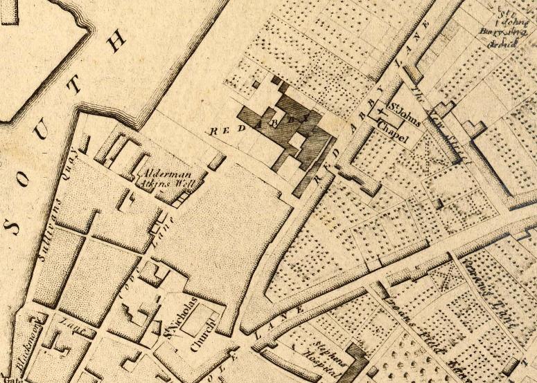
    But the blossoms in a place such as the Japanese Gardens were not always there. They cast shadows over the now fading memory of Douglas Nurseries, run by Atkins. Sixty years ago, a Welsh accent wafted in the air at this site as the site Manager Mr Jones went about his work. Mr Wolfe, enthusiastically looked on heading up the operation – the acts of making and nurturing something to grow and sowing seeds. There were 12-14 people working there. One of the lads was an old gentleman, Con O’Sullivan from Ballinlough. Where now St Anthony’s School is, there was a wall across there and that was the boundary of the nurseries. Inside that wall were the fruit trees. The premises extended all the way down to Douglas Road. There were several greenhouses in which tomatoes and flowers were grown. Outdoors, shrubs and fruit trees were also grown. One of the biggest jobs in Atkins was to make the compost. John Innes was a very famous brand in its day and we used to make it from various ingredients.

   As the late fifties developed the extent of Wolfe’s acreage lessened. Dave Bradley of Bradley Brothers was also making and sowing seeds in a sense. They were turning one house a week at one stage in the 1950’s and 1960’s. It was amazing how fast they moved. It’s amazing what they created. By the time they were finished one house they were moving onto the next. They built almost 1,500 houses in Ballinlough from Browningstown East, Ardmahon and Ardfallen estate, all the estates with Somerton; they did Beechwood Park and Belmont Avenue. At the top of Atkins, they developed what was deemed the good building land, which became Beechwood by the mid 1960s, fifty years ago. Dave Bradley’s mother liked trees and thought Beechwood would be a nice name for the estate.


Educational and Social Needs:

    Meanwhile the local clergy of the new parish of Ballinlough, just five years old in 1960 had their work cut out to embrace their new parishioners, mostly young and white collar workers, who in time gave Ballinlough a youthful population, who kicked ball around Ballinlough’s new roads, sat with Derry Cremin in Jock’s Murphys and discussed tactics for the next hurling match. In its demise, they harnessed the eventual ruins of Atkins for adventures, slocked apples from the various orchards from here, that of Hennerty’s to Kelly’s orchard on the site of The Orchard Bar to further afield and created landscapes of cowboys and Indian across the vast market gardens of Ballinlough.

    Fifty years ago, Ballinlough was a relatively young parish and community. It had the usual needs of a young growing community, which are educational, recreational and social. The parish priest of the time, Canon Eddie Fitzgerald, with the help of his priests and people, courageously faced those challenges. Indeed, amongst those young priests who came under the wing of the Canon Fitzgerald was Fr now Canon Michael Crowley.

   There were three schools in the parish, Ballinlough old boys school at the Silver Key, and Our Lady of Lourdes in Ballinlough and Crab Lane off Boreenmanna Road. These schools were totally inadequate to cope with the growing numbers of young boys and girls. Thornhill House was bought by the parish to provide temporal classrooms for the overflowing number of boys.

   Then Eglantine House on the Douglas Road was bought and converted into a school, opening in 1959. It was seen as a temporary solution to the growing number of girls in Ballinlough and surrounding areas. So great was the demand for places that stables in the yard belonging to Eglantine House had to be converted into classrooms. In time this temporary school was replaced by a new beautiful Eglantine school and the beautiful tree, which beset the ground was removed.


St Anthony’s School:

    The local Canon Fitzgerald, who was an elderly gentleman, had multiple interests especially in education. He became the first parish priest in 1955. His grandfather was Lord Mayor of Cork, Sir Edward Fitzgerald. He was the key instigator of the Cork International Expedition on the Mardyke in Cork City in the years 1902 and 1903. Energy and foresight ran in the Fitzgerald family. On one morning in the early 1960s, he and his curate, Fr Jeremiah Hyde set off searching for a new site for a boys school. They agreed that perhaps the upper half of the property of formerly Atkins Nursery could be built on. By the early 1960s the property had become that of Cork Corporation. Fr Hyde drove the Canon to Cork City Hall where he had a chat with city planners and the idea for the site of St Anthony’s School was born. People got together and raised funds for this new school, which we all now know as St Anthony’s. The rest is history with school celebrating its fiftieth anniversary this year.

   By the late 1960s, Ballinlough National School for boys as such was spread out in different buildings. You had the new building of St Anthony’s, Thornhill House, and there was the old national school near the Silver Key bar. Jack Corkery was the principal and his wife was principal in Eglinton School, which had opened in 1959. With the St Anthony’s complex, there were about eight or nine on the teaching staff. Vice-Principal Bart Whooley was also a respected teacher.

   Fifty years ago, the more relaxed confirmation process we enjoy today was more formal with Bishop Lucey sweeping through putting the sixth class to the test on all matters Godly. A stern man but ambitious for the city’s new suburbs with his amazing and architecturally exciting Rosary churches, coupled with schools and community centre. In the late autumn of 1959 while in the United States, Bishop Lucey, Bishop of Cork and Ross, impressed by the work of many Parish credit unions he saw in operation. During the visit he collected as much information as possible on the principles and practices of credit union. On his return to Cork, Bishop Lucey used every opportunity to promote the concept of a credit union.

    Fifty years ago, in the late summer of 1965 Fr John Ryan of Our Lady of Lourdes Church called a meeting with John Corkery, Dermot Kelly, and Paddy Hennessey in Thornhill House to sound out the idea of forming a credit union in Ballinlough. All agreed that it was an excellent idea and an immediate start was agreed upon. A working group consisting of five members attended a further meeting in September of 1965. The credit unions already established in the city, had initially started up study groups to explore the possibility of introducing the philosophy of credit union to their parishioners. It was agreed to follow this formula in Ballinlough, and that membership of the group would be by invitation only.

   The first meeting of the study group (by invitation only) was held at Thornhill House on 16 November 1965. There were twenty-two people, all male, in attendance and there was a pretty wide representation consisting of tradesmen, factory employees, clerical workers, a clergyman, school principal and a member of the legal profession. This represented a well-balanced reservoir of talent. Fr Ryan was proposed as group chairman and Paddy Hennessey as secretary. Fr Ryan agreed to act as chairman if the position rotated at each subsequent meeting.


The Weight of History:

   The roots of all these seeds from fifty years ago – the houses, estates, schools, the credit union – like the roots of the blossom trees run deep. The weight of history, past events, glory days, the voices and stories of thousands of individuals who have come through the driveway gates of houses, our schools, our Credit Union are all important to this area’s identity and sense of place – their roots remain strong fifty years on this year and needs to be continued to celebrated, explored and the lessons and messages of the past brought to bear in forging a future. The energy and aspiration of fifty years has survived into our time inspiring many community leaders in our time and they have the potential to inspire more.

    As we enter the lead –up to the commemoration of 1916, I think there are messages concerning inspiration will appear more and more in the next year. Just like the power of the blossom trees, threads such as renewal, re-birth, growth, hope, re-imagination and inspiration will spread through the nation’s psyche in the next few months.

  Thank you for your continued courtesy towards myself. You always learn something new about yourself in Ballinlough, indeed here is a place where you get stopped on the road for a chat, are challenged, encouraged, supported, helped and always pushed!

I would also like to thank the people of Ballinlough for their interest and support in my own community projects over the last six years now.

The Discover Cork: Schools’ Heritage or Local history project

The local history column in the Cork Independent, in the books I have been lucky to publish.

the community talent competition, which I have audition for

The Make a Model Boat Project on the Atlantic Pond, which is on 31 May,

and the walking tours through this ward; there are now ten of these – developed over the last number of years –

   As a new project to this great city, I have set up a musical society, Cork City Musical Society, so I’m directing and producing my first musical in early June in the Firkin Crane in Shandon. Also recently I have been appointed by the Minister of Environment as an Irish delegate to the EU’s Committee of the Regions, which meets in Brussels every six weeks for two days. The 350 member committee gives advice to the European Parliament on local authority issues. So hopefully there will be something there I’ll find that will benefit Ballinlough or share the positive community projects that go on here with other EU countries. I sit on two committees or commissions, the EU budget assessment committee, and the culture and youth unemployment one, so there is alot there to debate and bring about change in the wider picture again.

   I think as an area in the Council Ballinlough was lucky before the economic crash in attaining as much as it could in physically making it a great place – In the last five years the Council’s coffers have been slashed by 45 million euros– something that can be seen visibly on our streetscape – roads decay and crumble, hedges become overgrown, Douglas Pool has not been dealt with to make it into the place that this area needs; these are uphill battles as a Council we face and we must find solutions. All the old parks are rebooting with young families, our schools are packed to capacity, you can see that with the traffic chaos every morning and afternoon. I think as an area we need a proper playground and a multi-use games arena, which is something I continue to fight for in City Hall.

   I found last year in the canvass that the older people are being looked after by family and neighbours but do yearn to have a chat to people. The feedback I am getting is that there is certainly a need for a drop-in centre once a week or fortnight – perhaps in this building or in the church. There is certainly a need to hold and continue the work of the Meals-on-Wheels, the bowls Club, our tennis club, and the work of our youth club. The lack of volunteers coming forward is always apparent; we also need to have a chat to the secondary schools on the parish’s borders to build a new audience as such of interested volunteers.

   We have been fortunate with the top table’s leadership over the past 7-8 years. That been said I would like to see a change of the guard – keep the organisation moving in a fresh way. I think it has been great to see many organisations getting their chance at holding the chairperson position; I would like to see someone from the Youth Clubs getting a go and seeing what they can muster as the association climbs through renewal in our country. I think new blood would renew the association’s partnership with the community as well. I say this in a respectful manner and not to offend people.

   I’d like to thank the various organisations represented here for all their hard work. It is no easy task but one I know you deem important to pursue.

   Best of luck in the year ahead – the more optimism and solutions that are radiated from this hallowed community space and grounds the better in these times. In these AGMs, there should always be the sense of thanks and just like the blossom trees a renewal of spirit. Thank You.

Ends


Reference:

McCarthy, K, 2013, Journeys of Faith, Celebrating 75 Years, Our Lady of Lourdes, Ballinlough, Cork.

Kieran’s Our CIty, Our Town, 16 April 2015

788a. Conserved remains of Mary Rose, Tudor ship, Portsmouth Historic Dockyard 2014

Kieran’s Our City, Our Town Article,

Cork Independent, 16 April 2015

Cork Harbour Memories (Part 19)

Tudor Ships on the Lee


      George Carew’s Map of Cork or plan of the walled town of Cork is different to that of Muskerry. Dated to the late sixteenth century, sometime in the 1590s perhaps, the map depicts numerous structures, which emphasise Cork as a port and a place to be protected as an English outpost of trade. The town walls, the Tudor ships, and the suburban features such as abbeys and watch towers show a town prepared for any potential attack and the difficulties of an attack. The river is presented as an integral feature around which the plan is defined. Like the Map of Muskerry, it is an English-made map to control territory. Here a militarised maritime zone is depicted.

     At the heart of the map is Watergate, Cork’s central maritime gate with its associated port, dock and custom house. It would have been impressive in its mechanism in opening to leave ships in. The gate allowed access into a private world of merchants and citizens. The masts of ships moored would have creaked as they knocked against the stone quays. Built between two marshy islands, in the middle of a walled town, its entrance was between the two castles – King’s Castle and Queen’s Castle. Castle Street now occupies a section of the interior dock.

     Carew in his map places an emphasis on two Tudor style galleons at the base of his plan – one revealing its starboard side and the other its port side – both have their sails filled with wind – lines, ropes and ladders are almost frozen in an action to move; canons appear through the port holes as if ready for attack. The depiction of the two ships like this can only be speculated upon. Certainly the ships symbolise the link to the protection of the waters of the town and the wider harbour and the role of the English and local navy in its protection. They were symbols of Cork’s presence in a north-west European maritime culture. They were a reminder that to enter the River Lee estuary you would be met by force. Your ship was probably watched from the harbour mouth all the way up the Lee Estuary to the walled town.

   The reality of these galleons was far from comfort. The map does not show the enormous amount of crew needed to manoeuvre such ships. These vessels were large ocean going ships, four times as long as they were wide. They had a special deck for cannons. They were broad, slow and not very manoeuvrable. All year round, the interior of a galleon was damp, with a strong smell of tar, stagnant water and sweating unwashed me. For the most part, they were also dark. On the main deck, the only light came from openings in the centre of the deck, from ventilating hatches above each gun, or from the gun ports when their lids were open. Other light came only from candles.

   In an attempt to find out more about the workings of and symbolism surrounding Tudor ships, in recent months I travelled to Portsmouth to explore their historic dockyard and heritage complex. One of their purpose-built museums gives public access to view the ghostly timber ruins of the Tudor ship Mary Rose. Half of the ship was lifted from the sea-bed in October 1982, and is now undergoing conservation, as well as over 22,000 artefacts found on board, at Portsmouth. This major project provided opportunities to understand the ship, her essence, her weapons, equipment, crew and stores.

    The interpretative panels there reveal that the Mary Rose was built at Portsmouth between 1509 and 1511. Named for Henry VIII’s favourite sister, Mary Tudor, later queen of France, the ship was part of a large expansion of naval force by the new king in the years between 1510 and 1515. Warships, and the cannon they carried, were the ultimate status symbol of the sixteenth century, and an opportunity to demonstrate the wealth and power of the king abroad. The Mary Rose remained the second most powerful ship in the fleet and a favourite of the king. She was deemed to be a fine sailing ship, operating in the Channel to keep up links with the last English landholdings around Calais. She was a carrack, equipped to fight at close range.

   The Mary Rose was rebuilt in the 1530s. Her 1536 rebuild transformed her into a 700-ton prototype galleon, with a powerful battery of heavy cannon, capable of inflicting serious damage on other ships at a distance. The high castles (combat structures above deck) were cut down, decks strengthened, and she was armed with heavy guns, with 15 large bronze guns, 24 wrought-iron carriage guns and 52 smaller anti-personnel guns. The Mary Rose now had the firepower to engage the enemy on any bearing, and conduct a stand-off artillery battle. Some of the guns were mounted on advanced naval gun carriages, which made them far easier to handle and move on a crowded gun deck. The new emphasis on artillery reflected the mastery of gun founding in England, another development pushed by Henry VIII. It also reflected the need for a naval force to defend the kingdom against European rivals.

 To be continued…


Captions:

788a. Conserved remains of Mary Rose, Tudor ship, Portsmouth Historic Dockyard, 2014 (picture: Kieran McCarthy)

788b. Map of Cork, late sixteenth century as depicted in Sir George Carew’s Pacata Hibernia, or History of The Wars in Ireland (1633), vol. 2, opp page 137.

788b. Map of Cork, late sixteenth century


Kieran’s Our City, Our Town, 9 April 2015

787a. Kilcrea tower house, March 2015

Kieran’s Our City, Our Town Article,

Cork Independent,  9 April 2015

Cork Harbour Memories (Part 18)

Stories in Stone


   Staying with George Carew’s map of sixteenth century Muskerry (see last week), one of its concerns was the showing of castles and churches – his castles are marked with a circle and a dot whilst his churches are demarcated with a snowman type delineation. The dashed lines reflect fluctuating territorial lines between Gaelic families and Carew’s long list of allies and adversaries. The map also points to small woodland areas across the territory. Carew’s circled dots very much under represent the prominence of castles in the landscape. The majority were tall slender stone tower houses with an estate surrounding them. Many still stand as ruins, haunted in a sense by the human life that once drove survival and civilised structures in them. All are worthy of remark and all have been written about through the ages.

   The tower house at Kilcrea was built by Cormac MacCarthy in the mid fifteenth century and lies only a few miles from Cork City. In its heyday it provided a buffer area like Blarney Castle – that those who travelled west along the River Lee, knew they were entering retaken Gaelic territory. The name Kilcrea (Cill Chre) harks back to an earlier history and means the Cell of Cere, Cera or Cyra. St Cere, who lived in the sixth century. She is is said to have founded a nunnery about a mile east of the friary in the parish of St Owen’s, now called Ovens. It appears that Kilcrea was a location with ecclesiastical associations long before Cormac Láidir MacCarthy founded the Franciscan Friary there circa 1465 AD. The friary was dedicated to St Brigid of Kildare.

   A few fields west of the Franciscan Friary stands the impressive ruined tower house of Kilcrea. It was built by Cormac McCarthy, Lord of Muskerry and was situated nearly in the centre of the valley, within a short distance of the Bride. Although inferior in importance and size, to that of Blarney, it was and still is a considerable structure to walk around and explore in safety. John Windele, antiquarian, in his Historical and descriptive notices of the city of Cork and its vicinity (1839) eloquently describes the castle of Kilcrea as standing in isolation; ”the warrior pile, stands in stern loneliness, denuded of its circling woods, isolated and ruinous – a better taste may again restore to it some of its sylvan honours”.

   This abandoned “warrior pile” of blocks of limestone is like a complex jigsaw puzzle of stone and is well put together. This was a building made to last, made to be permanent. The stones are heavy – their weight now intertwining with the weight of history which now governs them. The quoin or corner stones and the material remains of mortar are testament to the masons who planned and put this prominent structure together. Its site is enclosed by a narrow moat still filled with water. The castle has a small fortified area at the eastern side of it, and is defended by curtain walls, and two square vaulted towers, now in ruins.

   Inside the keep, it is divided by two semi-circular stone arches (being turned on a kind of basket work of interwoven sallows, or willow wattles). One arch is above the other, at the heights of one third, and two thirds of the building. All of the intermediate floors have been destroyed. Stone corbels for timber floors remain to entice the visitor to think about creaking floor boards. The basement rooms like those at Blarney are merely lit by narrow loops. At the south side of the vestibule is a stair case, which consists of an easy flight of seventy-seven steps and runs up the entire height of the building, becoming spiral as it approaches the higher chambers. A number of small closets are attached to the upper rooms, all of which are vaulted.

           The upper chamber formed the main hall – a room of state and was at one time spacious and well lit. Its floor is now overgrown with grass. It was lit by three spacious windows, with stone mullons, and ogee headed tracery of a basic design – but enough to entice you to rub your hand over this ancient piece of art work. John Windele after his visit remarked that at the north side of the main hall chamber, was formerly a “capacious fire place with a well-executed mantle-piece, on the impost of which was an inscription, in raised letters commemorating rather modern repairs”. This was also removed some years before Windele’s visit and during my visit the missing fire-place was also quite apparent. From the ruined battlements is obtained an extensive view over the valley to the west, embracing the view of Castlemore and Cloghdha Castle near Crookstown.

   On my visit the hum of a nearby lawnmower seemed to bounce from wall to wall in the interior, making me look behind you at every corner. The structure is haunted by its stories and history. This haunting feeling is also one, which Windele also picked up upon; “it has been haunted by a phooka, or mischievous spirit, under the form of a black crow; so that nightly visitors would require strong nerves to brave the terrors of its lonely and forsaken chambers”.

To be continued…

Captions:

787a. Kilcrea tower house, March 2015 (picture: Kieran McCarthy)

787b. Interior of Kilcrea tower house, March 2015 (picture: Kieran McCarthy)

787c. Entrance arch and stairs, Kilcrea tower house, March 2015 (picture: Kieran McCarthy)

787b. Interior of Kilcrea tower house, March 2015

787c. Entrance arch and stairs, Kilcrea tower house, March 2015

Kieran’s Our City, Our Town, 2 April 2015


786a.  Map of Siege of Dunboy, late sixteenth century

Kieran’s Our City, Our Town Article, 

Cork Independent, 2 April 2015

Cork Harbour Memories (Part 17)

Carew’s Campaigns

    George Carew’s impact on the cultural and political landscape of Munster was vast. By the spring of 1586 Carew had been knighted and was sent on a private mission by Elizabeth I to Ireland. Carew arrived into a country where huge tracts of the Earl of Desmond’s lands in Munster had taken over by the English crown. About 300,000 acres of land were confiscated in total. From 1585, the plantation of Munster had began and new English settlers were given land. As a reward to Carew’s loyalty, he acquired large estates.

   Carew’s rise in political circles and in English power structures in Ireland was quick. In February 1588 Carew was appointed Master of the Ordnance, and returned to Ireland. In 1590 he was admitted to the Privy Council. Two years later in 1592 he was made Lieutenant-General of the English Ordnance, and in 1596 and 1597 he was engaged with Essex and Raleigh in expeditions against Spain. In March 1599 he was appointed to attend the Earl of Essex to Ireland and on 27 January 1600 he was made President of Munster.

    Carew’s proceedings for the next three years during his term as President are carefully detailed in Pacata Hibernia (1633), nominally written by Thomas Stafford, but inspired by himself. The Battle of Kinsale features prominently in his pages on campaigns in Cork. On 23 September, 1601, a Spanish fleet entered the harbour of Kinsale with 3,400 troops in forty-four vessels under the command of Don Juan del Aguila. They immediately took possession of the walled town. Del Aguila despatched a message to Ulster to O’Neill and O’Donnell to come south without delay. Lord Mountjoy and Carew mustered their forces, and at the end of three weeks encamped on the north side of Kinsale with an army of 12,000 men.

    O’Neill arrived on 21 December 1601 with an army of about 4,000, and encamped at Belgooly north of Kinsale, about three miles from the English lines. His advice was, not to attack the English, but to let their army suffer from the cold. Already 6,000 of them had perished. But he was overruled in a council of war, and a combined attack of Irish and Spaniards was arranged for the night of 3 January, 1602. Efforts to rally his ranks were in vain. Del Aguila’s attack did not come off and the Irish lost the battle of Kinsale. Soon after the battle Del Aguila surrendered the town. He agreed also to give up the castles of Baltimore, Castlehaven, and Dunboy, which were garrisoned by Spaniards. Shortly afterwards, he returned to Spain.

    The Dunboy Castle though was not given up without a fight. In April 1602 Carew took Dunboy Castle and estate, which was the stronghold of the O’Sullivan Bere clan and built to guard the harbour of Berehaven. The O’Sullivan Beres controlled the fishing fleets off the Irish coast and became rich through the collection of taxes on the rights of passage. Dunboy was surrendered to the Spaniards, on their invasion of Ireland in 1601 by its owner, Daniel O’Sullivan. Early the following year following the treaty at Kinsale the Irish clan took possession of the castle by surprise and seized the arms and ammunition the Spaniards had deposited there. Sir George Carew as well as 5000 soldiers were sent to suppress the O’Sullivan Bere. In April, the English army marched against the O’Sullivans to Bantry, and on 6 June set up camp on the opposite side of the castle’s bay.

     Dunboy Castle was considered impregnable and was only defended by 143 men under the command of Richard McGeoghegan. It took two weeks to take it during which it was almost destroyed by artillery fire. After hand to hand fighting the remaining 58 survivors were executed in the town square. The entire castle site lay in ruins until 1730 when the Puxley family were granted the Dunboy Estate along as well as other land belonging to the O’Sullivan’s. They then set about building a mansion close to the Puxley Castle keep and Dunboy Castle was left in ruins. Very little now remains of the old castle. It now comprises of just a few collections of stones which in parts are almost completely covered with overgrowth.

   The end of the Cork wars found the country in a deplorable condition of ruin and depopulation. Carew and the other English leaders, and their Irish allies, profited largely by the confiscations that ensued. Carew returned to England in March 1602 at the earnest request of his friend Cecil. Carew stood in as high favour with King James I as with Elizabeth, and in the Irish Patent Rolls are recorded the numerous grants bestowed on him from time to time. In 1605 he was created Baron Carew, and was made Governor of Guernsey. In 1611 he was again despatched to Ireland as head of the commission for the plantation of Ulster.

   The favour which followed him through the reigns of Elizabeth and James continued unabated under Charles I, by whom he was created Earl of Totnes. Much of his later years were spent in arranging his invaluable collection of papers connected with the history of Ireland. Carew died at the Savoy, London, 27 March 1629, aged about 72, and was buried at Stratford-upon-Avon. He left one daughter. His Countess survived him many years.

To be continued…


Captions:

786a. Map of Siege of Dunboy, late sixteenth century as depicted in Sir George Carew’s Pacata Hibernia, or History of The Wars in Ireland (1633), vol. 2, opp page 191.


786b. Ruins of Dunboy Castle, present day (picture: Kieran McCarthy)

786b. Ruins of Dunboy Castle, present day