Category Archives: Landscapes

Kieran’s Our City, Our Town, 19 November 2015

819a. Richard Boyle’s tomb, St Mary’s Church, Youghal

Kieran’s Our City, Our Town Article,

Cork Independent, 19 November 2015 

Cork Harbour Memories (Part 38) 

A Defender of Church and Town


   The vast estates of the Fitzgeralds, the Earl of Desmond dynasty (see last week), were confiscated in the reign of Elizabeth I, and granted to various English settlers (called planters or undertakers). The names of the new settlers in Ireland who obtained grants of the Desmond estates in Cork and Waterford, were Sir Walter Raleigh, Arthur Robins, Fane Beecher, Hugh Worth, Arthur Hyde, Sir Warham St. Leger, Hugh Cuffe, Sir Thomas Norris, Sir Arthur Hyde, Thomas Say, Sir Richard Beacon and (the poet) Edmond Spencer.

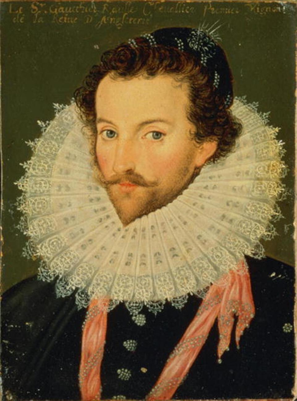
   Walter Raleigh (c.1554-1618) had taken part in the suppression of the Desmond rebellion in 1579 and profited from the subsequent distribution of land. He received 40,000 acres or 162 km2 which included the important towns of Youghal and Lismore. This allowed him to become one of the principal landowners in Munster, but nevertheless had only some degree of success in convincing English tenants to settle on his estates. Youghal was the home of Sir Walter Raleigh for brief periods during the seventeen years in which he held land in Ireland. The decade of the 1590s coincided with difficulties on Raleigh’s Irish plantations at a time when his own fortunes were in decline. He sold his Irish estates in 1602 to Richard Boyle, thus ending his involvement with the plantation of Munster.

   Richard Boyle (1566-1643) is closely associated with the history of Youghal, purchasing the town as part of his acquisition of the Munster estate of Sir Walter Raleigh. On the rich array of heritage information panels in Youghal, the story of Richard Boyle’s influence is related. Boyle occupied the office of Sheriff from 1625 to 1626. He had a substantial residence, known today as The College, close to St. Mary’s Collegiate Church. Boyle recognised the suitability of Youghal area for the production of pig iron, for which there was great demand in England. A plentiful supply of timber for charcoal, rich iron ore deposits, water power and a great port area all combined to generate an active iron industry in the early seventeenth century. The yew woods from which Youghal derived its name (Irish: Eochaill) were used to supply the ironworks of Richard Boyle.

   Amongst the other legacies of Boyle’s influence in Youghal are the Almshouses, which he endowed to house six old soldiers, who were to receive a pension of £5 per annum. This service was later broadened to include widows. The six houses were constructed in 1610 and continued in use in their original form until the mid-nineteenth century, when some alterations took place. They are now owned by Youghal Urban District Council and still serve a similar generous purpose.

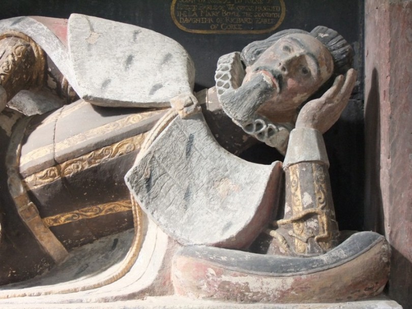
  In 1606 Richard Boyle paid for the south transept of St Mary’s Church to be rebuilt, as a mortuary chapel for his family. Boyle’s journals record that the south-transept was the place ‘wherein the townsmen in time of rebellion kept their cows’. In subsequent years he spent thousands of pounds on the restoration of the church, including rebuilding the chancel. Historian Dr Clodagh Tait in an article in the Royal Irish Academy has an article entitled Colonising memory: manipulations of death, burial and commemoration in the career of Richard Boyle, first earl of Cork. Dr Tait describes the Earl of Cork’s “energetic tomb-building”, which cost him well over £1000, was a means of demonstrating that “he had arrived, and had created a fortune and a dynasty”. Boyle symbolically presented himself as the “spiritual successor of Youghal’s ancient inhabitants”, and as the “defender of the town and its church”. Viewing the relaxed sculpture on his tomb of a smiling Boyle lying on his side with his family around him shows how he did manipulate the meanings around how he was to be commemorated in history.

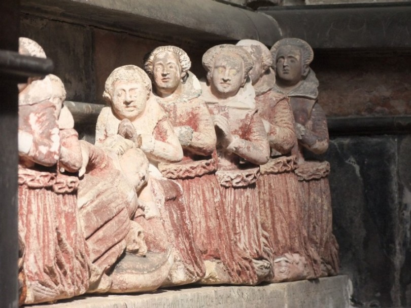
 Architect Alexander Hillis of London erected Boyle’s tomb in the south transept in 1620. The monument, heavily influenced by renaissance architecture, was the height of fashion when it was built. The work is still surrounded by its original protective wrought-iron railings displaying further pieces of family heraldry. The swords shown at the bottom are a symbol of Boyle’s power, justice and the armour of God. It shows Boyle himself reclining, with his first and second wives, Joan Apsley and Katherine Fenton respectively, to either side, his mother Joan Naylor over, and a few of 16 children, kneeling in a row in front of him. His first wife died in childbirth and she is represented with a baby at her feet. The skulls portray someone already dead at the time the monument was carved.

  Boyle himself died in 1643 and was buried here in his monument with his mother – but not his wives. Incidentally, a further elaborate monument by Boyle can be found in St. Patrick’s Cathedral in Dublin. It was erected to Katherine Fenton, his second wife (died 1630) and finished in 1632. Boyle’s second wife Catherine Fenton bore him fifteen children before she expired at the age of 42. Of the eight daughters, seven were married to noblemen. Of the seven sons, four were ennobled in the lifetime of their father. The most notable of this extensive offspring was Robert Boyle, the natural philosopher and author or Boyle’s Law.

To be continued…


Captions:

819a. Richard Boyle’s tomb, St Mary’s Church, Youghal (pictures: Kieran McCarthy)

819b. Detail of Richard’s face, Richard Boyle’s tomb, St Mary’s Church, Youghal

819c. Richard’s children in sculpture, Richard Boyle’s tomb, St Mary’s Church, Youghal

819b. Detail of Richard’s face, Richard Boyle’s tomb, St Mary’s Church, Youghal

819c. Richard’s children in sculpture, Richard Boyle’s tomb, St Mary’s Church, Youghal

Kieran’s Our City, Our Town, 12 November 2015

818a. Ruins of Richard Boyle’s early seventeenth century manor house at Castlemartyr Resort


Kieran’s Our City, Our Town Article,

Cork Independent, 12 November 2015 

Cork Harbour Memories (Part 37)

The Gems of the Fitzgeralds


      East Cork of the early 1600s possessed a number of old Fitzgerald family castles, which passed to Richard Boyle (1566-1643). John Speed’s map of c.1610, part of his collection of maps of Britain and Ireland from The Theatre of the Empire of Great Britaine (1611-12), showcases these structures within named territories of Irish and English lords. Three more sites are generally detailed below (continued from last week), whose ruins have survived into the modern day Irish landscape.

   Ballymartyr Castle is marked on Speed’s map, which survives as a key attraction on the Castlemartyr Resort estate. The ruins of the impressive Boyle manor house, its exterior walls, chimneys, its bawn or enclosure wall, a mural tower, and a fortified house survive as well the five-storey tower house. The tower is quite possibly an earlier structure. The historical records for the site detail a chequered history but certainly there is a sense that there is much to still much to discover and interpret about its role in the formation of the layered histories of East Cork. It is known that the first castle was first built in 1210 by the Knights Templar under the leadership of Richard Earl de Clare, also known as Strongbow. By the mid fifteenth century, the castle was the seat for the local seneschal or steward of the regional Lord appointed by James, Earl of Ormond. Ballymartyr Castle was captured in 1569 by Elizabeth’s Lord Deputy of Ireland Sir Henry Sidney, when Ormond’s men abandoned the castle overnight after a cannon attack. Sidney had initially proposed the appointment of a military governor (Lord President) in the provinces of Munster and Connacht. This incited the first of the Desmond Rebellions led by James Fitzmaurice Fitzgerald of the Geraldine family. Ballymartyr was subsequently given to Sir Walter Raleigh, and later managed by local Elizabethan steward John FitzGerald. The Earl of Ormond attacked the castle in 1579. John FitzGerald was eventually captured in 1583 and died a few years later in Dublin Castle in 1589.

    During the early seventeenth century, Richard Boyle, the first Earl of Cork, built a magnificent Manor House, whose exterior walled ruins are impressive to explore and circumnavigate. It is only when you stand by its walls that you appreciate how significant this court-like-castle would have been in the East Cork countryside showcasing a marker of a change in leadership and architecture in early seventeenth century Irish society. In the 1640s, the citizens of the castle again witnessed conflict and changed hands twice more before being set on fire to prevent it being used as a base for the Irish Confederate forces. During the civil war, the castle was captured by the Irish, and then recaptured by the Williamites in 1690, but was badly damaged and eventually abandoned and fell into disrepair. It was Henry Boyle (1682-1764), 1st Earl of Shannon and ancestor of Richard Boyle, who built the eastern portion of the present mansion house or hotel and who set about beautifying the estate between the years 1733 and 1764.

   Located c. 3 miles west of Castlemartyr village in the parish of Ballyoughtera and the barony of Imokilly is Ballintotis Castle. Its proposed restoration in 2008 led to a request for an impact assessment to be prepared and a log in the great archaeology website, www,excavations.ie. It is a small square tower-house that was built as an outer defence for the Castlemartyr estate in the sixteenth century. The castle and lands were granted to George Moore in 1579 in gratitude for his contribution to the wars in Scotland and Ireland. The castle is included in the Down Survey of 1655 and the lands of ‘Killurgane and Ballytotis’ are listed as being the property of Edmund Fitzgerald at this time. The castle survives today as a small, standard four-storey tower-house.

  Ballintotis Castle today is entered at ground-floor level by an arched door near the north end of the west wall. Part of a high rubble limestone wall survives to the west of the tower, which is interpreted as part of the original bawn wall or part of a former building which abutted the castle. The initial phase of monitoring for restoration focused on the removal of topsoil for a new driveway leading from the castle to the public road. All works associated with the insertion of services and the removal of waste from the tower-house were also monitored. Margaret McCarthy, the author of the detail on excavations.ie, details that during restoration no features of archaeological significance were identified on the surface and the finds consisted of three fragments of post-medieval ware.

   Inchiquin castle of the Fitzgeralds is also marked on Speed’s map. It is one of the few round structured castles in County Cork. The walls are from 8-12 feet thick. In 1322 a document mentions it as a round tower built of stone. It was the property of the Fitzgeralds and was a dower house for widows of the Desmond family. According to legend, the Old Countess of Desmond lived here for 70 years and died in 1604 tradition says aged 140 (!). So myth from this time has also survived in the local folklore of the area which intertwines with the landscape. Walter Raleigh later owned this property in time and sold it to Richard Boyle.

To be continued…


Captions:

818a. Ruins of Richard Boyle’s early seventeenth century manor house at Castlemartyr Resort (picture: Kieran McCarthy)

818b. Section of East Cork from John Speed’s Province of Munster, from his The Theatre of the Empire of Great Britaine, c.1610-11 (source: Cork City Library)

818b. Section of East Cork from John Speed’s Province of Munster, from his The Theatre of the Empire of Great Britaine, c.1610-11

Kieran’s Our City, Our Town, 29 October 2015

816a.  Main Street Bandon, c.1900

Kieran’s Our City, Our Town Article, 

Cork Independent, 29 October 2015 

Cork Harbour Memories (Part 35)


Boyle’s West Cork Towns


   Last week I mentioned Richard Boyle (1566-1643), the first Earl of Cork, and his interest in creating industrial complexes such as ironworks and associated plantation settlements. His main estates were in counties Cork and Waterford but he also owned significant property in county Kerry, including lands in the baronies of Corkaguiny and Dunkerron South. In the early seventeenth century maps of Munster, some of the key settlements which Boyle was involved in creating appear. In time, many of these developed into well loved and beautiful County Cork towns – for example Bandon and Clonakilty – both of which underpin West Cork’s regional heritage and identity.

   Professor Pat O’Flanagan’s Historic Town Atlas of Bandon relates that Boyle had an involvement in Bandon, in perhaps what could be described as its second phase of development. Bandon derives its name from the erection of a bridge over the river Bandon, and owes its origin to the English planters on the great Desmond forfeitures in the reign of Elizabeth. In 1609, James I granted to Henry Beecher the privilege of a Saturday market and two fairs at the town. Power was given to him and his heirs to appoint a clerk of the market in the newly erected town of Bandon-Bridge, or in any other town within the territory, with the privilege of licensing all tradesmen and artisans settling in them.

   The grants were shortly afterwards purchased by Richard Boyle the first Earl of Cork, whose efforts in promoting the town’s growth and prosperity led him to rewrite history as such and to be regarded as the founder of the town. He peopled it with a colony of Protestant merchants from Bristol and established iron-smelting and linen-weaving industries, all of which in a few short years flourished and increased in extent and importance. The manufacture of camlets, stuffs, and other woollen goods prevailed in Bandon to the close of the close of the eighteenth century and the beginning of the nineteenth century, and was succeeded by the spinning and weaving of cotton, which continued to flourish till 1825. Spinning-mills were then erected on a large scale, and more than 1000 people were employed in weaving, Both branches of industry diminished, in so much as the mills became less busy and not more than 100 weavers were employed as the mid nineteenth century progressed.

  In the early seventeenth century, Bandon was under continuous attack by dispossessed Irish native families such as the O’Mahony’s. Subsequently, in 1620 Richard Boyle began the construction of a wall around the town. The wall took approximately five years to build and enclosed an area of 27 acres. Much of the walls were nine feet thick and varied in height from thirty to fifty feet. There were six round towers with additional defences provided by cannon. The river openings were protected by iron flood gates and fences. The gates were built within an archway capable of allowing the tallest cart-load to pass through. They were imposing portals and strengthened with portcullises. The bridge was built of stone and consisted of six arches. Within the walls Boyle built 250 houses. There were also three urban tower houses.

  Nearby the town of Clonakilty was formally founded in 1613 by Richard Boyle when he received a charter from King James I. It appears to have replaced the nearby medieval settlement of Kilgarriff as the focus for urban development. Boyle was constituted lord of the town, with power to appoint several of the officers and to a certain extent to superintend the affairs of the corporation, which was to consist of a sovereign and not less than 13 nor more than 24 burgesses. The sovereign was annually elected by the lord of the town out of three burgesses chosen by the corporation, and the recorder was also appointed by him. The charter conferred the right of sending two members to the Irish parliament, which it continued to exercise till the Act of Union. He settled 100 English families here. Established as a market town it was engaged chiefly in the manufacture of linen and cotton through its elaborate mills. Breweries were developed in the eighteenth century and corn and potatoes were exported to Cork. The present town was largely laid out in the period 1788-1840.

   Samuel Lewis in his Topographical Dictionary of Ireland describes Boyle’s legacy of sorts in Clonakilty in 1837; “The staple trade of the town was linen manufacture, which furnished employment to 400 looms and 1000 persons, who manufactured to the amount of £250 or £300 weekly. The cotton-manufacture also employed about 40 looms. A spacious linen-hall had been built some years previous by the Earl of Shannon…The corn trade was carried on chiefly by agents for the Cork merchants, who shipped it there and received coal as a return cargo”. In 1837, Lewis described that there were 14 lighters or boats of “17 tons burden each” regularly employed in raising and conveying sand to be used in the neighbourhood as manure. The nearby harbour was only fit for use for small vessels, the channel was extremely narrow and dangerous, and had at its entrance a sand bar, over which vessels above 100 tons could only pass at high spring tides. Large vessels, therefore, discharged their cargoes at the warehouses at Ring, about a mile below the town, the ruins of which still can be seen today.

 To be continued…


Captions:

816a. Main Street, Bandon, c.1900 (source: West Cork Through Time by Kieran McCarthy & Dan Breen, Cork City Museum).

816b. Boyle’s legacy, Mill Street, Clonakility, c.1900 (source: West Cork Through Time by Kieran McCarthy & Dan Breen, Cork City Museum).

816b. Boyle's legacy, Mill Street Clonakility, c.1900


Kieran’s Our City, Our Town, 22 October 2015

815a. Proposed portrait of Richard Boyle, early 1600s

Kieran’s Our City, Our Town Article,

Cork Independent, 22 October 2015

 Cork Harbour Memories (Part 34)

 Wood, Iron and a Seventeenth Century Millionaire


   In the first two decades of the 1600s, the Munster plantation was re-established and re-constituted by the Governor of Munster, George Carew. The plantation was successful in its endeavours to bring more planters to Ireland. By 1611, five thousand planters were recorded in Munster which rose to twenty-two thousand by 1641. On the one hand, with this colonisation came an influx of skilled craft-workers which led to an increase in the country’s productivity. However, on the other hand, the colonisation led very quickly to large scale Anglicisation, which attempted to destabilise Irish society by introducing new English ways of laws and social traditions.

   Joe Nunan of Blackwater Archaeology in his research work details the economy of the Munster plantation and how it grew grew steadily. The extraction of timber and iron yielded large profits but the plantation areas also rapidly developed a strong export trade in cattle and sheep. Ironworking was successful in Munster (and elsewhere) as there appears to have been significant amounts of woodland (for fuel). In the timber trade large numbers of New English settlers within the region were involved in large scale woodland clearance. Hardwoods of the Blackwater, the Lee and the Bandon River Valleys satisfied the English demand for ship timbers, barrel staves and charcoal. Boyle and Jephsons of Mallow were known as two key families of several who were involved in the export of timber. A Philip Cottingham was sent over by the crown in 1608 to survey Munster’s woods and in particular inspected the work of entrepreneur Richard Boyle. The survey detailed that much of the best timber had already been used up for pipe and barrel-staves. By 1620 Spain and France were importing many of their staves from Ireland. Walter Raleigh, in partnership with Henry Pyne, also forged a key role in their production and export from woodlands on the Cork and Waterford boundary, which were located along the Bride River.

    With reference to iron production, in Munster between 1607 and 1630, there was also a rapid growth in iron production. High international prices contributed to the construction of iron manufacturing in counties Cork and Waterford, which were situated near the Bandon, the Lee and the Blackwater Rivers. Timber, charcoal and labour were less costly than in England. Richard Boyle was involved in the ownership, establishment and leasing of many ironworks along the lower Blackwater and the Bride Rivers, while the East India Company established ironworks on the banks of the Bandon River.

   Recently I attended a historical walking tour of Youghal organised by the Irish Post Medieval and Archaeology Group and led by Cork author, industrial archaeologist and eminent scholar Dr Colin Rynne of UCC who is completing an Irish Research Council project (With Dr David Edwards, History UCC) entitled “the colonial landscapes of Richard Boyle, 1st Earl of Cork, c. 1602-1643”. The project, which delves into the extensive archives of Boyle’s estate, details that he was viewed by his contemporaries as a model English planter, who best realised the aims of the Munster Plantation, forging a model English Protestant ‘commonwealth’ on his estates. In his lifetime Boyle was to become the wealthiest subject of King Charles I.

   Richard Boyle was an entrepreneur from Canterbury who became one of the most powerful characters in Britain and Ireland during the early seventeenth century. In December 1601, Walter Raleigh sold his 42,000 acre Irish estate to Richard Boyle for the paltry sum of £1500. The purchase included the towns of Youghal, Cappoquin and Lismore, all linked by the navigable River Blackwater, as well as castles, lands and fisheries, with the extra bonus of the ship Pilgrim. Temple Michael, Molana Abbey and the parkland at Ballynatray were also now given over to Richard Boyle. Richard Boyle had a substantial residence, known today as ‘The College’, close to St. Mary’s Collegiate Church.

   Boyle set to settle his lands with English planters, and to build towns and forts. On 25 July 1603, he married his second wife, Miss Fenton, daughter of Sir J. Fenton, Master of the Rolls. On this occasion, at St Mary’s Church, he was knighted by Sir George Carew. He was created a Privy-Councillor in 1606, Lord Boyle, Baron of Youghal in 1616, Viscount Dungarvan and Earl of Cork in 1620, and in 1629 he was made Lord-Justice, in conjunction with his son-in-law, Viscount Loftus; Boyle was made Lord-Treasurer in 1631. His mansion in Dublin, on the site of the present City Hall, gave the name to Cork-hill. He selected as his family motto “God’s providence is my inheritance.”

    Richard Boyle’s main estates were in counties Cork and Waterford but the estate also owned significant property in county Kerry, including lands in the baronies of Corkaguiny and Dunkerron South. Roger Boyle, a younger son of the 1st Earl of Cork, was created Earl of Orrery in 1660 and was granted lands in counties Cork, Kerry, Limerick and Kilkenny in 1666 amounting to almost 14,000 acres. Indeed the extent of Boyle’s estates will really only be revealed through the publication of the UCC project under Dr Colin Rynne and Dr David Edwards in the next year or so.

More next week…


Captions:

815a. Proposed portrait of Richard Boyle, early 1600s (source: Cork City Library)

815b. Youghal Main Street from the top of the Clock Tower looking towards the Blackwater Estuary, taken during a recent fieldtrip of the Irish Post Medieval and ArchaeologyGroup (picture: Kieran McCarthy)

815b. Youghal Main Street from the top of the Clock Tower looking towards the Blackwater Estuary

Kieran’s Our City, Our Town, 15 October 2015

814a. Depiction of Cork’s interior dock, the Watergate complex

Kieran’s Our City, Our Town Article, 

Cork Independent, 15 October 2015

Cork Harbour Memories (Part 33)

 A Busy Seventeenth Century Settlement


 Cork in the first decades of the seventeenth century was valued as the third most important port after Dublin and Waterford. The growth in prosperity was mainly attributed to the increase in utilization of the surrounding pastoral hinterland surrounding the city. Large sections of woods were cleared in Munster to accommodate the large demand for pasturalism. However, in 1610, a report by the commission of the Munster Plantation noted that the woods were being depleted too fast in order to clear land so sheep could graze on it.

  In the early 1600s, it is recorded that the main areas that Cork was importing from and exporting to included Seville in Spain, Lisbon in Portugal, St Malo and the Saintonge area in the south-west of France, cities in the north of Italy such as Pisa, western English port cities such as Bristol, Cologne and the Rhine area in Germany and towns such as Delft in northern Holland. New trading connections were also established with the Canary Islands and Jersey. The main imports from the first four countries in the above list mainly consisted of wine while from the others iron and salt were the principal imports. This is also reflected in the archaeological evidence from sites with preserved late medieval contexts. A large percentage of the pottery discovered dating to the seventeenth century was from the warm temperate countries where wine was grown.  

  Hides, tallow, pipestaves, rugs and friezes were the main exports along with cattle, wool and some butter. There was an increasing trade in beef, which led to the moving of slaughter houses or shambles outside the city walls. Indeed, such was the extent of active trade in Cork whether it be exporting or importing, that there was increased activity in the pirate activities. It eventually reached the stage where special convoys were introduced to protect merchant ships especially around the south coast.

    The physical nature of the walled city appears constantly in Cork Corporation priority list regarding revamps. The old Corporation records detail the worsening condition of the town walls. In January 1609, a plan to build a new court house on the site of King’s Castle, which was the northern control tower of the central Watergate into the town, was delayed. The walls onto which the courthouse were be attached were crumbling and in danger of collapsing. New walls would have to be built, so the new courthouse could be built.

   The poor condition of the town walls continued to be a major issue for the Corporation into the decades of the 1610s and 1620s and even the bridges leading into the town were described as ruinous and calls were made for them to be mended. From 1614 on, all monies earned by the Corporation from taxing imports such as wine were to be spent the repairing of the walls. However, by 1620, it was agreed that the incoming revenue into the settlement’s coffers was not enough and a bye-law was passed where several municipal rates were to be brought in as well as increasing of existing rates. Taxes were raised on several regularly exported commodities such as animal feed such as oats, animal skins such as horse, deer, fox and on drinks such as beer and wine. However, the taxes regarding docking your boat, passage through the city, tax on the land you owned were abolished.

   In 1620, an English traveller described Cork as “ a populous town and well compact, nothing to commend it…the town stands in a very bog and is unhealthy”. The physical state of the town also became an issue in May 1622 when lightning struck one of the thatched roofs in the eastern part of the city which caused a large scale fire to rapidly spread from one thatched roof to the next. According to the historical records, the fire began between eleven and twelve o’ clock in the morning.   Indeed, apart from one clap of lightning there was also a second clap of lightning which lit the houses in the western part of the city. It is detailed that the since the houses overlooking the main street were in flames, the people trapped between the two fires were forced to flee into the city’s main churches, Christ church on South Main Street and St. Peter’s on North Main Street. Both of these churches are recorded as being constructed of stone and having a slated roof which saved the lives of numerous townspeople. The people who did not make into the churches were unfortunately consumed by the fire itself. In September 1622, an order was passed that the stone walls be built and the roofs be replaced by slate or timber boards.

   The early seventeenth century was an era of unprecedented social upheaval whereby a large part of society consisted of a Catholic majority ruled by a Protestant sovereign. As the seventeenth century progressed, Catholicism became more a political movement than a religious one which aligned itself and made full use the church in Rome as a reason for rebellion.

 To be continued…..


Captions:

 814a. Depiction of Cork’s interior dock, the Watergate complex, from John Speed’s ‘Corke’ from his Province of Munster c.1610-11 (source: Cork City Library)

 814b. Depiction of Cork Harbour and East Cork from section of John Speed’s Province of Munster, c.1610-11 (source: Cork City Library)

 814b. Depiction of Cork Harbour and East Cork

Kieran’s Our City, Our Town, 8 October 2015

813a. Section of John Speed’s Province of Munster


Kieran’s Our City, Our Town Article,

Cork Independent8 October 2015

 Cork Harbour Memories (Part 32)

 The Theatre of Empire


  The online map archive of the city through the ages makes for great viewing at www.corkpastandpresent.ie. The early seventeenth century is well represented. One beautifully engraved and hand-coloured map is by John Speed (1552-1629) of the province of Munster taken from The Theatre of the Empire of Great Britaine (1611-12). In the corner of the map is a representation of the walled town of Cork. Though dated 1610 and mentioning London based publishers John Sudbury and George Humble. It was 1616 before it was actually published in Amsterdam by globe maker and map engraver Jodocus II Hondius with the assistance of George Humble, who also acted as Speed’s editor. Sudbury and Humble were the largest and most successful publishers and print-sellers in London.

   The Munster map is embellished with an engraving of a man (a cartographer?) wielding a large pair of dividers, while he stands on top of the scale of Irish miles; in Youghal harbour is a galleon ship and in the Atlantic is a boy playing the harp whilst sitting astride a remarkable winged sea creature. Present day Munster comprises six Irish counties but the province has to this day many churches and ancient castles that are depicted on this map. The map abounds with the names of local clans and families – it is inscribed in a very personal way – but its use was also political showing the controlled hidden corners of the British empire.

    There are two inset town plans on the map of the most prominent towns in the province at the time – Cork and Limerick, both of which were fortified with large town walls and built on rivers. In the Cork map, the northern suburbs, present day Shandon Street is shown along with Shandon Castle and the remains of the Franciscan Abbey on the present day site of the North Mall. In the southern suburbs, structures such as the Augustinian Abbey, the earthen ramparts of Elizabeth Fort, while further west an old medieval church associated with the remains of a round tower encompassed by a wall are depicted.

   The Oxford Dictionary of National Biography records that John Speed as beginning his working life as a tailor in the northern English county of Cheshire. He pursued his apprenticeship under his father, a local tailor, and carried on the family business for a number of years. His attention to detail and a keen interest in cartography, led him to try his hand at map making. He began to display a uncharacteristic talent for this and, despite still working as a tailor, Speed created and published his first known map in 1595 – a map of Canaan.

   Soon afterwards, Speed was patronised by Sir Fulk Revil, It was this generosity that allowed Speed to depart for London, still as a teenager, and focus on his education at the College of Antiquaries. He became absorbed in his studies, developing his keen interest in history, and soon a specialist interest in the history of cartography. With the help and advice of various associates of Sir Fulk Revil, he pursued the notion of creating a complete and precise atlas of the British Isles.

   Speed took the first step with his home county of Cheshire, completing the map with one of the earliest town plans of Chester with arms and vignettes which were to become his signature style. Engraved by William Rogers, this map was published individually in 1604. He continued to cover all the counties of England and Wales. The resulting atlas, finally published in 1612, was titled The Theatre of the Empire of Great Britaine. This remarkable work was published in partnership with the already established house of John Sudbury and George Humble. The atlas, bought by the University Library in 1968, is now considered priceless. It contains a single sheet for each county of England and Wales, plus a map of Scotland and each of the four Irish provinces, and paints a rich picture of the countryside at the turn of the seventeenth century. Cambridge University Library is home to one of only five surviving proof sets. Their map department elegantly describes Speed’s maps: “Rivers wriggle through the landscape, towns are shown as huddles of miniature buildings, woods and parks marked by tiny trees and – with contour lines yet to be invented – small scatterings of molehills denote higher ground”.

   The ‘Theatre’ was a great success and was published again many times and by a number of publishers: Sudbury and Humble notably published their second edition of The Theatre in 1627, the last edition to be published before Speed died. In 1627, Speed released his other major work: A Prospect of the Most Famous Parts of the World. This finely detailed and embellished world atlas, the result of many years development alongside The Theatre, includes the notable accolade of being the first world atlas to be published by an Englishman. The Prospect was to be his last major work. John Speed died on 28 July 1629 having created some of the most remarkable cartography.

To be continued…


Captions:

813a. Section of John Speed’s Province of Munster, from Speed’s The Theatre of the Empire of Great Britaine, c.1610-11 (source: Cork City Library)

813b. John Speed’s ‘Corke’ from his Province of Munster (source: Cork City Library)

813b. John Speed’s ‘Corke’ from his Province of Munster

Cllr McCarthy’s New Book, North Cork Through Time

  The second of three books Kieran McCarthy has been involved in penning this year focuses on postcards of historic landscapes of North Cork. Entitled North Cork Through Time, it is compiled by Dan Breen of Cork Museum and Kieran and published by Amberley Press.

  The region is defined by the meandering River Blackwater and its multiple tributaries and mountainous terrain to the north. It borders four counties that of Kerry, Limerick, Tipperary and Waterford. The postcards, taken for the most part between c.1900 and c.1920 show the work of various photographers, who sought to capture the region and sell their work to a mass audience. Not every town and village were captured in a postcard. This book brings together many of the key sites of interest and serves as an introduction to the rich history of the region.  In the postcards, one can see the beauty that the photographers wished to share and express.  The multitude of landmarks shown in this book have been passed from one generation to another, have evolved in response to their environments, and contribute to giving the County of Cork and its citizens a sense of identity and continuity.

 Chapter one explores the border territory with County Kerry – a type of frontier territory for Cork people – its history epitomised in the elegant and well-built Kanturk Castle, the gorgeous town of Millstreet with its international equestrian centre and its access into the old historical butter roads of the region. Chapter 2 centres around the Limerick Road from Mallow to Charleville – Mallow a settlement with a heritage dating back 800 years and straddles the winding River Blackwater. 

   Chapter 3 glances at the area east of the Mallow-Limerick Road taking in the stunning Doneraile estate with the adjacent and spacious streetscape of the connected village.  Killavullen, Castletownroche and Kilworth all present their industrial pasts. Mitchelstown stands in the ‘Golden Vale’ of the Galtee Mountains, its heritage being linked back to the Kingston estate and their big house, which dominated the local landscape with views on all it surveyed.  Chapter 4 explores Fermoy, which because of its history and connection to a local military barracks possesses a fine range of postcards. Its bridge and weir, views of the Blackwater, the nineteenth century square, colourful streetscapes all reveal the passion for such a place by its photographers. North Cork Through Time by Kieran McCarthy and Dan Breen is available in any good bookshop.


Kieran’s Our City, Our Town, 24 September 2015

811a. Banks of River Blackwater at Fermoy, c.1910

Kieran’s Our City, Our Town Article,

Cork Independent,  24 September 2015


Kieran’s North Cork Through Time

   It’s been a very busy year. The second of three books I have been involved in penning this year focuses on postcards of historic landscapes of North Cork. Entitled North Cork Through Time, it is compiled by Dan Breen of Cork Museum and I and published by Amberley Press.

   It is easy to get entangled with the multi-storied landscapes of North Cork. It is a region with so many stories to tell, veins of nostalgic gold from tales of conquest to subtle tales of survival. There are many roads to travel down and many historical spaces to admire. The enormous scenery casts a hypnotic spell on the explorer. The region is defined by the meandering River Blackwater and its multiple tributaries and mountainous terrain to the north. It borders four counties that of Kerry, Limerick, Tipperary and Waterford. The postcards, taken for the most part between c.1900 and c.1920 show the work of various photographers, who sought to capture the region and sell their work to a mass audience. Not every town and village were captured in a postcard. This book brings together many of the key sites of interest and serves as an introduction to the rich history of the region.

  In the postcards, one can see the beauty that the photographers wished to share and express. The multitude of landmarks shown in this book have been passed from one generation to another, have evolved in response to their environments and contribute to giving the County of Cork and its citizens a sense of identity and continuity. Cultural heritage does not end at monuments and collections of objects. It also includes traditions or living expressions inherited from our ancestors and passed on to our descendants. Pilgrimages and rituals are also engrained in many of the scenes within the postcards. Even mundane performances can construct a historic past and help weave personal and local memories with established national and regional historical narratives.

    In many of the postcards, the scene is set up to elicit a response and to create a certain emotion within us, or because they make us feel as though we belong to something – a region, a country, a tradition, a way of life, a collective memory, a society. North Cork is blessed with such an array of diversity in heritage sites and there is a power in that diversity.

   Chapter one explores the border territory with County Kerry – a type of frontier territory for Cork people – its history epitomised in the elegant and well-built Kanturk Castle, the gorgeous town of Millstreet with its international equestrian centre and its access into the old historical butter roads of the region, the use of secondary rivers for transport and industry, and the development of railways lines.

   Chapter 2 centres around the Limerick Road from Mallow to Charleville – Mallow a settlement with a heritage dating back 800 years and straddles the winding River Blackwater. The town came into its own in the nineteenth century with the development of its main street, churches, academies, convents, viaduct, clock tower and spa house, all interwoven with the commemoration of Ireland’s famous writer and poet, Thomas Davis. The idea of an interwoven and multi-narrative heritage is also present in Buttevant. A former walled town, its medieval fabric is shown in its streetscape and old tower, Franciscan church and the ruinous Ballybeg Abbey in the town’s suburbs. On the latter site its columbarium or pigeon house reminds the visitor of the importance of seeing the human side of our heritage – that people minded the birds and in a cherished way created the house with all its square roosts. Charleville also connects to an English colonial past being a late seventeenth century plantation town named after Charles II.

   Chapter 3 glances at the area east of the Mallow-Limerick Road taking in the stunning Doneraile estate with the adjacent and spacious streetscape of the connected village. Killavullen, Castletownroche and Kilworth all present their industrial pasts. Along the Blackwater, Ballyhooley Castle stands in defiance of time, as does Moorepark and Glanworth Castles, just off the old Fermoy-Mitchelstown Road. The nineteenth century estates are very prevalent in old stone walls, old ruinous and rusted gateways. There are exceptions such as Castlehyde, which stands as a testament to the affection of the Flatley family, the current guardians of its heritage, but also a salute to the many families who inherited such estates and landscapes. Mitchelstown stands in the ‘Golden Vale’ of the Galtee Mountains, its heritage being linked back to the Kingston estate and their big house, which dominated the local landscape with views on all it surveyed.

   Chapter 4 explores Fermoy, which because of its history and connection to a local military barracks possesses a fine range of postcards. Its bridge and weir, views of the Blackwater, the nineteenth century square, colourful streetscapes all reveal the passion for such a place by its photographers. Still today, you can almost hear the hoof noises and creaking carriage wheels of the Anderson coach works and the marching of the military in the now disappeared army barracks. Above all Fermoy through its heritage exhibits a strong sense of place, a proud settlement, traits which pervade across North Cork and its landscape.

North Cork Through Time by Kieran McCarthy and Dan Breen is available in any good bookshop.


Captions:

810a. Banks of River Blackwater at Fermoy, c.1910 (source: Cork City Museum).

810b. Banks of River Blackwater at Fermoy, present day (picture: Kieran McCarthy)

811b. Banks of River Blackwater at Fermoy, present day

Kieran’s Our City, Our Town, 12 September 2015

809a. Deirdre Moriarty getting ready to prepare the Rokk Choir at the recent Coal Quay Festival


Kieran’s Our City, Our Town Article,

Cork Independent,

Discover Cork: Schools’ Heritage Project 2015-16

10 September 2015


 This year coincides with the thirteenth year of the Discover Cork: Schools’ Heritage Project. Again launched for the new school term, the Project is open to schools in Cork; at primary level to the pupils of fourth, fifth and sixth class and at post-primary from first to sixth years. There are two sub categories within the post primary section, Junior Certificate and Leaving Certificate. A student may enter as an individual or as part of a group or a part of a class entry.

    Co-ordinated by myself, one of the key aims of the project is to encourage students to explore, investigate and debate their local heritage (built, archaeological, cultural and natural) in a constructive, active and fun way. Projects on any aspect of Cork’s rich heritage can be submitted to an adjudication panel. Prizes are awarded for best projects and certificates are given to each participant. A cross-section of projects submitted from the last school season can be gleamed from this link on my website, www.corkheritage.ie where there are other resources, former titles and winners and entry information as well.

 Students produce a project on their local area using primary and secondary sources. Each participating student within their class receives a visit and workshop in October 2015. The workshop comprises a guide to how to put a project together. Project material must be gathered in an A4/ A3 size Project book. The project may be as large as the student wishes but minimum 20 pages (text + pictures + sketches). Projects must also meet five elements. Projects must be colourful, creative, have personal opinion, imagination and gain publicity before submission. These elements form the basis of a student friendly narrative analysis approach where the student explores their project topic in an interactive and task oriented way. In particular students are encouraged to attain material through visiting local libraries, engaging with fieldwork, interviews with local people, making models, photographing, cartoon creating, making DVDs of their area. Re-enacting can also be a feature of several projects.

   For over thirteen years, the project has evolved in how students actually pursue local history. The project attempts to provide the student with a hands-on and interactive activity that is all about learning not only about heritage in your local area (in all its forms) but also about the process of learning by participating students. The project is about thinking about, understanding, appreciating and making relevant in today’s society the role of our heritage- our landmarks, our oral histories, our scenery in our modern world for upcoming citizens. So the project is about splicing together activity on issues of local history and heritage such as thinking, exploring, observing, discovering, researching, uncovering, revealing, interpreting and resolving. This year as well there is a focus on the 1916 commemoration side with projects on the centenary being encouraged.

    The importance of doing a project in local history is reflected in the educational aims of the history curricula of primary and post-primary schools. Local heritage is a mould, which helps the student to become familiar with their local environment and to learn the value of it in their lives. Learning to appreciate the elements of a locality, can also give students a sense of place in their locality or a sense of identity. Hence the Project can also become a youth forum for students to do research and offer their opinions on important decisions being made on their heritage in their locality and how they affect the lives of people locally. Over the years, I know a number of students that have been involved in the project in schools over the years who have took their interest further and have gone on to become professional tour guides, and into other related college work.

   The project is open to many directions of delivery. Students are encouraged to engage with their topic -in order to make sense of it, understand and work with it. Students continue to experiment with the overall design and plan of their work. For example in general, students who have entered before might engage with the attaining of primary information through oral histories. The methodologies that the students create provide interesting ways to approach the study of local heritage. Students are asked to choose one of two extra methods (apart from a booklet) to represent their work. The first option is making a model whilst the second option is making a DVD. It is great to see students using modern up todate technology to present their findings. This works in broadening their view of approaching their project.

   This project in the City is kindly funded by Cork City Council (viz the help of Niamh Twomey), the Heritage Council and Cork Civic Trust (viz the help of John X. Miller). Prizes are also provided by the Lifetime Lab, Lee Road and Sean Kelly of Lucky Meadows Equestrian Centre, Watergrasshill (www.seankellyhorse.com). There is also a County Cork edition. Overall, the Schools’ Heritage Project for the last thirteen years has attempted to build a new concerned generation of Cork people, pushing them forward, growing their self-development empowering them to connect to their world and their local heritage. Spread the word please.


Captions:

809a. Deirdre Moriarty getting ready to prepare the Rokk Choir at the recent Coal Quay Festival (picture: Kieran McCarthy).

809b. A walking tour getting underway at Elizabeth Fort during the recent Cork Heritage Open Day (picture: Kieran McCarthy)


809b. A walking tour getting underway at Elizabeth Fort during the recent Cork Heritage Open Day