Category Archives: Uncategorized

Kieran’s Our City, Our Town, 22 January 2015

776a. Kieran’s map of thirteenth century County Cork market towns

Kieran’s Our City, Our Town Article,

Cork Independent, 22 January 2015

Cork Harbour Memories (Part 7) – The Towns We Know Well


   In the thirteenth century, places such as the walled town of Cork, and developing towns such as Kinsale and Youghal became centres for collecting masses of local produce for export. How these towns interlinked with each other and worked for the benefit of each other for the Anglo-Norman frontier in southern Ireland are interesting questions.

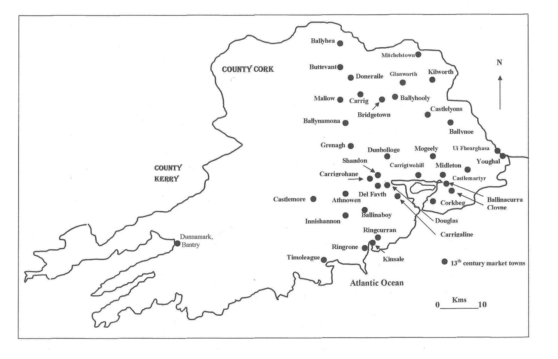
      As part of the colonisation process, sub collection points in the county were deemed important. The Sheriff of Cork in June 1299 listed 38 Anglo-Norman related market towns up and running in the most fertile countryside of County Cork. Today the majority are well known settlements; some were recognised as having further potential and developed into the villages and towns we know today. The map, inset, shows a web of frontier settlements, which were strategically placed adjacent feudal manors, on important inland routeways, fordable points of rivers and near coastal access. If one overlays main roads on this map, the settlements also influenced the development of rough roads to and from them – the early lines of some of the county’s well known routeways were created, especially roads from Cork to Fermoy, Mallow, Kinsale and to Youghal. These market spaces influenced political and civil order in and around them; their presence would have influenced spaces for people to belong to, to be controlled in and would have created their own identity structures. They maintained and encouraged the creation of agriculture practices. The regulation of trade became the lot of these locations, through administration, paper work, and the granting of privileges and immunities to its traders.

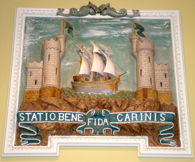
     Both Kinsale and Youghal have striking and beautiful built heritage, both were founded in the early thirteenth century. In the last number of years, in Youghal the Heritage Council and Town Council have worked up an insightful report (Conservation Plan, 2008) in an attempt to conserve and showcase its town walls. Youghal received its charter of incorporation from King John in 1202. It was mostly populated by new settlers from Bristol, a city that retained strong trading links with Youghal during the medieval period. These links are also inherent in the town’s coat of arms, the same as Bristol’s – a tower and a ship. In the thirteenth century growing trade and the presence of native Irish living outside the town required the citizens of Youghal to enclose an area of approximately 17 hectares with a wall.

    In 1224, Maurice Fitz-Gerald founded a Franciscan monastery on the south side of the town, which was the first religious foundation of the order in Ireland. It is recorded that he originally intended the building for a castle, but that, in consequence of some harsh treatment which the workmen received from his eldest son, he changed his design and determined to devote it to religious uses: but, dying in 1257, it was completed in 1260 by his second son, Thomas, whose son, in 1263 or 1271, founded a Dominican monastery, called the Friary of St Mary of Thanks. At this time the town had attained some commercial eminence, for in 1267 the amount of customs paid was £103. By the late thirteenth century and early fourteenth century Youghal was the sixth largest port in Ireland, after New Ross, Waterford, Cork, Drogheda and Dublin, trading timber and wool for spices, grain and wine with the rest of Ireland, England, Wales, and Europe. The principle ports of England and Wales supplied the town with the products of their different industries.

    In 1226 King Henry III granted permission to Andrew Blundus to have a weekly market at his manor in Kinsale. In the years following this grant, extant town records tell of Irish attempts to subvert the new feudal systems. These factors led in the course of time to the establishment of an Anglo-Norman garrison in the area. Believed to have been commenced during the mid-thirteenth century, Kinsale’s town walls were repaired in the mid-fourteenth century, damaged in the battle of Kinsale in 1601, largely destroyed in the siege of 1690 and subjected to some repairs in the eighteenth century. Samuel Lewis, in his Topographical Directory of Ireland in 1837 notes that “three of the gates were remaining till near the close of the last century; Nicholas gate was removed in 1794, Friars gate in 1796, and Cork gate in 1805”.

   The fourteenth century in Cork marked further progression in the development of the town as an Atlantic port. In 1326, Cork became a “staple” town. In otherwords, it was required by English law that Cork became an official market place. Dublin and Drogheda were also made staple towns. The regulations attached to a staple town in summary were far more attractive to foreign merchants than to the Irish themselves. Foreign trade was encouraged under this new system and it suppressed any profit making initiatives on the part of the native Irish. This new law was only one of several laws enacted in order to attract more foreign trade into Ireland. Such was the success of the Irish laws, in 1353, Bristol became a staple town as well as several other ports in England.

 To be continued…

 Kieran’s new book, Cork Harbour Through Time (with Dan Breen) is now available in Cork bookshops. 

Caption:

 776a. Kieran’s map of thirteenth century County Cork market towns/spaces, as listed by the Sheriff of Cork, June 1299 (source: information collected in A F O’Brien’s chapter Politics, Economics and Society, c.1170 to 1593 in P O’Flanagan & C Buttimer, Editors, 1993, Cork History and Society, pp-93-94).

Cork City Council Twinning Grants, 2015

Cork City Council has an open call for providing grants to Cork city based groups who are willing to pursue activities to promote the twinning links between any of the twinned cities subject to certain conditions. Cork city is twinned with 6 cities, Cologne, Germany, Coventry, United Kingdom, Rennes, France, San Francisco, U.S.A., Swansea, Wales and Shanghai, China.

Twinning committee member Cllr Kieran McCarthy noted “The twinning grant scheme is an ideal source of funding to get ideas off the ground and connect Cork people to other cities of international importance. The nature of the activity may be community based, voluntary, social, business, cultural, educational, sporting or of general social and economic benefit”.

An activity which is likely to develop and deepen links and generate new contacts with a twinned city will be given extra consideration. The twinning activity may involve travelling to a twinned city but travel is not a pre-requisite for awarding a grant. The maximum grant awarded is 50 percent of what is proposed. All applications must be supported by detailed programmes and financial projections. Application forms, together with the conditions applying, are available from the Reception Desk, Cork City Council, City Hall, Cork. Closing date for receipt of applications is 5p.m on Friday, 27th February 2015.

Kieran’s Question to the City Manager/ CE and Motions, Cork City Council Meeting, 12 January 2015

Question to the CE:

To ask the CE about why the Cork Main Drainage hoarding on Penrose Quay, opposite the old Steam Packet Office is still present? This hoarding and dug out space has been unresolved for the length of the last Council. It is ugly; inside is untidy and does not lend itself to any future plans for that area. Can management finally bring this issue to a successful conclusion? (Cllr Kieran McCarthy)


Motions:

That the roof of local studies in Cork city library be fixed (Cllr Kieran McCarthy)

To get a report on the next steps of revamp at Fitzgerald’s Park, especially on the proposed kitchen garden and the new playground (Cllr Kieran McCarthy)

Kieran’s Our City, Our Town, 18 December 2014

773a.  Cork Coat of Arms, Custom House, Cork

Kieran’s Our City, Our Town Article,

Cork Independent, 18 December 2014

Cork Harbour Memories (Part 4) – The Bristol Connection


      As Cork developed in the twelfth century, from historical and archaeological perspectives, one of its earliest known connections to another port city was with Bristol. Bristol Ham Green Pottery has been found in large numbers beneath our old medieval core; our coats of arms are similar – Bristol has one tower and a ship; Cork’s first English charter in 1185 refers to similar privileges. It was these issues that encouraged my visits to England’s largest western city, Bristol in recent years.

       On first approach, topographically, Bristol is a city of hills with sharp slopes but no great altitudes. The outskirts of the settlement cover a series of low ridges. Indeed, the approach from the south is similar to the approach from Cork Airport to Cork City, involving panoramic views of a large connurbation. Bristol grew initially as a Roman bridging point and this is reflected in its original name, Bristow. The growth of its port occurred in the middle of the first millennium AD. By 1,000 AD an Anglo-Saxon town was well established. The advent of the 1060s coincided with conflict in Anglo-Saxon England in the form of the Anglo-Norman invasion and their famous historical victory on the battle-fields of Hastings in 1066. By 1069, it is argued that many Saxons were unprepared to accept the Anglo-Norman conquest as final and fled England to Ireland to regroup. From Dublin, they made two attempts to re-establish themselves in England. Bristol was the main focus of this attack. As a result circa 1087, a motte and bailey structure was built by Anglo-Normans in Bristol. This was restructured in the 1110s by a more substantial stone structure. Surrounded by the River Froom, the castle itself has been described as a large fortified manor. By 1083, Bristol was in Royal possession.

     The 1086 Domesday Book regarded Bristol as not unlike medieval London, an area thinly peopled and unfertile in itself, but containing a settlement of some size which rendered a substantial revenue from its surrounding hinterland. Economically, the city was ranked as been on par with York, Lincoln and Norwich. Indeed, from the twelfth century onwards, many western European cities experienced rapid urban growth. In most cases, the growth of towns was in conjunction with a mercantile class and the growth of internal and external trade. Indeed, the growth of maritime trade was a general European trend (of which Cork was also part of).

      As the Hiberno-Norse developed towns in places in Ireland such as Cork, the 1100s in Bristol coincided with conflict and change. In the 1130s and 1140s further rebellions against Anglo-Normans by Anglo-Saxons occurred while the first of the royal charters to Bristol was granted in 1155. Primarily, a grant was given towards creating toll toll-free passage through King Henry’s dominions in England, Wales and Normandy. Between 1164 and 1170, another charter was given in favour of those who dwelt in the marsh by the bridge of Bristol. A new parish church was also created in the form of St’s Mary’s Redcliffe. From here Redcliffe pottery was created, some of which is found in Cork’s medieval layers. Pottery is still made in Redcliffe today.

       In 1169, Bristol was to become the staging point of the Anglo-Norman Invasion of Ireland under the direction of Henry II. Such was the swiftness of this invasion that by 1171, documentary evidence shows Bristolians living in Dublin. However, it is noted by Bristol historians that the city used to engage in slave trade with Viking ports in Ireland. Perhaps, the Irish connection was already strong and maybe slave ships came into Cork Harbour to shelter. An Anglo-Norman charter was also granted to Dublin in this year. Though London was developing as the principal city in England, Bristol became the main key to Anglo-Norman boroughs in the west. In 1188, Bristol became the model for the civic constitution of the Anglo-Norman boroughs and trading centres in Ireland. Indeed, it could be said that it was these places that Bristol had more links with than with London. Anglo-Norman Lords were quick to see that the major Danish Viking trading ports had the potential for large financial success. Consequently, Dublin, Waterford, Limerick and Cork in time became royal boroughs.

         In the case of Cork, the Hiberno Norse settlement was taken for the Anglo-Norman King by Milo De Cogan and Robert Fitzstephen and fortified. In time a large, stone wall, on average eight metres high enclosed the South Main Street area, a circa six acre site. Bristol was chosen by the Anglo-Norman Monarchy as the model to be followed by these Irish towns regarding liberties, privileges and immunities. The year 1185 has been accepted as the date of Cork’s first charter. All customs and rent structures in the initial years of Anglo-Norman Cork were the same as what the citizens possessed in Bristol’s walled town. Dublin received its second Bristolian charter in 1192 while Limerick received its first Bristolian charter in 1199 and Waterford in 1205. These settlements were to prosper with similar privileges as English Anglo-Norman Towns. They were also to become centres of political and administrative control but also provided defence and security. It was a combination of both political and economical factors that promoted growth of these towns.

To be continued…


Happy Christmas and happy new year to all the readers of this column

Caption:


773a. Cork Coat of Arms, Cork Custom House (picture: Kieran McCarthy)

Cork Harbour Through Time

Cork Harbour Through Time

Ten Historical Items about Cork Harbour

(extracted from Kieran McCarthy’s and Dan Breen’s New Book)


  1. Dating back over 1,000 years to Viking times, from the Anglo-Norman time of a walled town to the present day, boats of all dimensions have been travelling through Cork’s riverine and harbour region, continuing a legacy of trade.


  1. Cork’s Marina, originally called the Navigation Wall, was completed in 1761. In 1820, Cork Harbour Commissioners formed and purchased a locally-built dredger. The dredger deposited the silt from the river into wooden barges, which were then towed ashore. The silt was redeposited behind the Navigation Wall. During the Great Famine, deepening of the river created jobs for 1,000 men who worked on creating the Navigation Wall’s road – The Marina.


  1. At one time, approximately fifty mansions in the south-eastern suburbs of Cork City overlooked Cork Harbour. One of the largest was that of Lakelands, owned by the Crawford family. By 1792, William Crawford Snr had moved from County Down to Cork, where he co-founded of the successful Beamish and Crawford brewery. He occupied a fine residence – Lakelands at Blackrock – to the east of the city, overlooking the widening River Lee.


  1. The imposing Blackrock Castle is the third structure on the site. The original fort (or castle) was built in 1582 by the citizens of Cork to safeguard ships against pirates, who would come into the harbour and steal away the vessels entering the harbour. In 1722 and 1827, the old tower was destroyed by a fire and a new one built.


  1. The history of fishing and fishermen in Blackrock dates back to the early 1600s. In 1911, sixty-four fishermen, ranging in age from fourteen to seventy, are listed in the census as living in Blackrock village and operating in and around the castle, Lough Mahon and harbour area.


  1. The District of Douglas village takes its names from the river or rivulet bearing the Gaelic word Dubhghlas or dark stream, which enters the tidal area nearby. As early as the late thirteenth century, King John of England made a grant of land to Philip de Prendergast near the city of Cork. On 1 June 1726, the building of the Douglas Factory commenced. Samuel Perry & Francis Carleton became the first proprietors.


  1. The Cork, Blackrock & Passage Railway opened in 1850, and was among the first of the Irish suburban railway projects. The original terminus, designed by Sir John Benson, was based on Victoria Road, but moved in 1873 to Hibernian Road (as shown above and now built upon). The entire length of track between Cork and Passage was in place by April 1850 and, within two months, the line was open for passenger traffic.


  1. With the establishment of a dock and shipyard in Passage West in the nineteenth century, many merchants became shipowners, and carried on an extensive trade in their own vessels. Three of these individuals were well-known entrepreneurs – William Parker (who engaged in foreign speculations in shipping), Thomas Parsons Boland and the Brown family.


  1. During the nineteenth century, many merchants in Passage West built their own big houses and terraces. This town recorded upwards of 100 covered cars called jingles engaged almost daily in the transport of people between Passage and Cork. Steamboats and several small boats also ploughed the waters between Cork and Passage several times daily.
  2. A letter from Vice-Adm. Thornborough of Trent, Cork Harbour, dated 28 August 1813, was read to the Ballast Board on 2 September 1813. In this letter he pointed out the danger vessels frequenting Cork Harbour were put in, as a result of the lack of a lighthouse at the entrance to the harbour. This small lighthouse was working by June 1817, but its tower was not conducive to a major harbour of refuge and port and, in 1835, it was replaced by the present larger tower.

Kieran’s Our City, Our Town, 11 December 2014

772a. Carved toy boat, found at archaeological excavations on South Main Street

Kieran’s Our City, Our Town Article, 

Cork Independent, 11 December 2014

Cork Harbour Memories (Part 3) – Recovering the Vikings

    The recent publication Archaeological Excavations at South Main Street 2003-2005, edited by Ciara Brett and Maurice Hurley, brings many nuggets of information to the public realm on early to mid twelfth century Cork. Amongst several objects found was a little toy boat (p.202), about 10cm in length (with one half missing), with one side grooved out and the other having a very elaborate tracery design. Here is an object lost in the fragmented timber wreckage found on South Main Street, found at the old seeping and reclaimed edges of a marshy island. One can almost imagine a young person playing with the boat at the water’s edge – and the bobbing up and down action in the water of this cherished object.

    The boat, small though it is, was once a part of someone’s daily landscape, their life, and their surroundings. Perhaps, the owner regularly played with it; perhaps there was a mini fleet of toy boats. It inspired someone to think differently about their surroundings. The young owner may have envisioned the immediate meeting of land, river and sea as a space of recreation, of possibilities, of dreams and a place of re-imagining old and new worlds. Perhaps the long rushes and reeds created a hiding space for imagined enemies. The boat may have meant so much to someone and held their ideas, future prospects and hopes when they played with it.

     However for us, in the present, the memory of the boat is beyond our personal memory. The knowledge of living in twelfth century Cork has not survived the test of time. This fragment of an artefact from their landscape offers us a way to identify with them, their perception and their lives. We can broaden, narrate and animate more parts of their story. It’s like a window into the past but it is also a looking glass because it innately tells us something about ourselves. It also allows us to contrast and compare cultural evolution through time and space, centuries ago children were plying with model boats. That being said with all the developments, the cultural transformations, the changes to the landscape, to our identity, taking all of this into account, it’s amazing that children still play with model boats. So much is different yet some things remain unchanged.

      The toy boat is rooted culturally in wider European Viking age settlements. This year coincided with a large exhibition on their life and legacy in the British Museum during the summer and which now is on display in Berlin. Entitled Vikings, Life and Legend, the exhibition brings together the various strands of thought on Viking colonisation a thousand years ago in north west Europe and beyond. What is revealed is the depth of their culture, their interest in arts and crafts, their ability to practically own the ‘sea highways’ of their day. Ships on the seas were central to how their culture spread, was maintained and framed for their ancestors. In the exhibition, the organisers detail that the first Viking campaign in England took the form of scattered attacks, but in 865AD the Vikings arrived, and in successive years conquered almost all of eastern England, the Dane-law. In France and Germany the Vikings met a strong monarchy. Nevertheless they attacked the Frankish coastal areas in the early ninth century.   

    Around 920AD they controlled much of Britain disparate parts of Ireland. By the eleventh century, they had conquered enormous tracts of England and founded and built towns. Cork was part of these networks of flows of knowledge between different Viking ethnic towns in north-west Europe. The extent of the networks of Cork’s Hiberno-Norse society (Viking ancestry and Irish Viking relationships) is relatively unknown though.

     The other remarkable aspect of the toy boat object is its ‘clinker style’ look and the carved Celtic like tracery on its base. Ongoing re-construction work at Roskilde Ship Museum in Denmark reveals that Viking Age ships were clinker-built. Characteristic of this construction technique of that the ship’s shape is created as an empty shell of strakes or longitudinal strips of timber, after which internal stiffening beams are added. The overlapping planks are caulked with wool and tar and are riveted together with iron nails. Over the last 1,000 years the Scandinavian clinker technique has been preserved in the traditional Danish, Norwegian and Farose boats used for fishing and transportation and the construction technique has left traces in the French, German and British and Irish boatbuilding culture.

    Three re-used timbers, interpreted as possible ship timbers from clinker-built vessel, were revealed at excavations at 40-48 South Main Street. The tree ring and scientific analysis of one of these timbers reveals that it was “derived from a mature oak felled after 1037 AD from southeast England, probably in the London area” (Nigel Nayling, p.203). The presence of iron fastenings securing oak planks at an overlap with luting of animal hair and tar were also present. The timbers had been reused as a base pad for one of a number of large upright posts, possibly part of a timber-framed house – the very first settlement foundations of Cork City are sitting on ship’s timbers and link to stories and culture further afield.

    The publication Archaeological Excavations at South Main Street 2003-2005 is available in Liam Ruiseal Bookshop, Cork and Waterstones Bookshop, Cork.


Caption:

772a. Carved toy boat, found at archaeological excavations on South Main Street (Illustration by Rhoda Cronin and Courtesy of Cork City Council)


Kieran’s Question to the City Manager/ CE and Motions, Cork City Council Meeting, 8 December 2014


To ask the CE about issues in Fitzgerald’s Park:

What were the tender details and process for the cafe behind the Museum?

What happened to Seamus Murphy’s sculpture ‘Seasons’, which was on the old band stand?

Can Seamus Murphy’s ‘Dreamline’ be turned around or placed elsewhere; one side of its face is weathering very poorly?

What are the 2015 projects for the Lord Mayor’s Pavillion?


Motions:

That the plans for the extension of the Ceili platform at the Lough be examined and accelerated (Cllr Kieran McCarthy)

That a plan be implemented for the replacement of fallen trees in the Marina and Atlantic Pond area (Cllr Kieran McCarthy)

Kieran’s Our City, Our Town, 4 December 2014

771a. Archaeologists from Sheila Lane & Associates digging at the Grand Parade City Car Park 2004

Kieran’s Our City, Our Town Article,

Cork Independent, 4 December 2014

Cork Harbour Memories (Part 2) – The Wreckage of the Past


   The amount of boats that have plied Cork Harbour is immeasurable. The large volume of extant admiralty charts from different periods of time point to negotiation around rocks, shallows and islands, and show carved out navigation routes. Whereas today, every metre of the harbour is mapped, what about those who rowed around it thousands of years ago exploring its corners and niches, hunting and fishing, and where the stars and landmarks were their mental maps.

    The names of two islands, Haulbowline and Foaty Island, hark back nearly a thousand years to the first know group of sailors – the Vikings and their ancestors, who harnessed the harbour for survival. The name Haulbowline may come from the Old Norse áll-boeli meaning an ‘eel dwelling’ whilst Foaty may comes from the Irish fód te, meaning ‘warm soil’; it could also comes from Old Norse fótey, meaning ‘foot island’, maybe referring to its location near the end of the river.

    The recent publication Archaeological Excavations at South Main Street 2003-2005, edited by Ciara Brett and Maurice Hurley, brings the reader back to a time where the natural environment of forests, the River Lee’s estuarine silt and the sheltered harbour were explored and mined for their resources. It is the eighth carefully researched and thought provoking book on the archaeology and history of Cork to be published by Cork City Council. This publication outlines the results of two large-scale excavations which took place at 36-39 and 40-48 South Main Street. Both sites are located in close proximity to the South Gate Bridge, one of the main entrances to the medieval walled town of Cork. The results of the excavations are significant as they have added to our knowledge of the formation and development of the City.

   There are many fantastic revelations in this book about reclamation from the swamp to outlining in detail the material culture from pottery to the use of wood for housing to gaming pieces.  The excavations were undertaken by Sheila Lane and Associates and the Department of Archaeology, UCC. Cork City Council. The various contributors work hard to paint a picture of their respective sites across several centuries. In particular in this book they place a large focus on Cork in the early twelfth century, a period before the Anglo-Norman invasion. By that time, the Hiberno-Norse, those living in Ireland with a Norse ethnic background, were rooted and settled in places such as Cork, Waterford, Wexford, Limerick and Dublin. Indeed, in all the latter places, excavations have taken place and the role of the Hiberno-Norse society debated in books and articles. The role of their early ancestors in piracy is much portrayed in the nation state’s Irish history books but their role in creating early towns not as much. The general collective memory within Cork’s history has, over several centuries, reduced them to the date of the first attack on Cork’s monastery (820AD) and an almost passing nod to the fact that they built a settlement on a swamp. The new book by Ciara and Maurice continues the pursuit of putting the Vikings on the academic history map and also implanting them into the popular imagination of Cork’s past – the latter perhaps being a harder task when it comes to changing the present day collective memory of a city.

    For whatever reason, the people of Cork, through several centuries, chose to forget the Vikings, their history and ultimately their legacy. For all intensive purposes, the excavated South Main Street sites and everything found from the twelfth century, belongs to the wrecking ball of time and to the wreckage of forgetting. On troweling back the earth, the archaeologists pealed back different temporal contexts. Two to three metres underneath our present day city, they exposed the remains of timber structures lingering, intrusive and protruding through the mud – these were ruinous, abandoned, broken, segmented, mixed up, rotting, crumbling, and aged on the edge of a swamp. The timbers were the sinking roots, cultural products and ideas of a long lost settlement – an enigmatic space where no written documentation existed for bar the variations in the rings of the timbers. The rings alluded to growth and resilience, an age before use and being part of a woodland at one stage in their life. Despite their decaying image, the intensity of construction and some details in the skilled carpentry work remained for all to see.

           At this crossroads of time, according to expert David Brown (p.525 in the book) there is an indication from the dendrochronological dates of the timbers found on the site that there was a continuous felling of trees and construction of buildings and reclamation structures from just a few years before 1100AD to 1160AD. So here on a swamp 900 years ago, a group of settlers decided to make a real go at planning, building, reconstructing and maintaining a mini town of wood on a sinking reed ridden and wet riverine and tidal space. One has to admire their intent, vision, tenacity and of course their legacy is the eventual reclamation of other marshy islands and the creation of the city of Cork.

    The publication Archaeological Excavations at South Main Street 2003-2005 is available directly from the City Archaeologist Ciara Brett (ciara_brett@corkcity.ie, 021-4924705) and is also available in Liam Ruiseal Bookshop, Cork and Waterstones Bookshop, Cork.

More on this next week…

Captions:

771a. Archaeologists from Sheila Lane & Associates digging at the Grand Parade City Car Park 2004; in the picture from the top right, South Gate Bridge Debtor’s Gaol (c.1713), thirteenth century town wall (centre), thirteenth century house foundations (right of centre), and twelfth century revetments (bottom right) [picture: Kieran McCarthy, 2004]