Kieran’s Our City, Our Town Article,
Cork Independent, 22 January 2015
Cork Harbour Memories (Part 7) – The Towns We Know Well
In the thirteenth century, places such as the walled town of Cork, and developing towns such as Kinsale and Youghal became centres for collecting masses of local produce for export. How these towns interlinked with each other and worked for the benefit of each other for the Anglo-Norman frontier in southern Ireland are interesting questions.
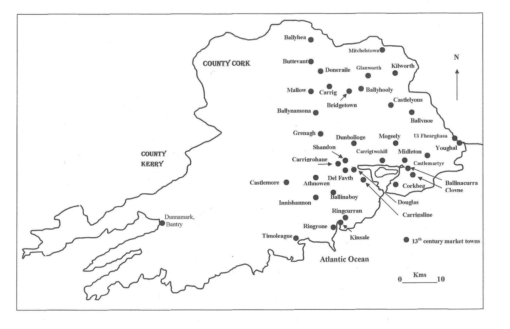
As part of the colonisation process, sub collection points in the county were deemed important. The Sheriff of Cork in June 1299 listed 38 Anglo-Norman related market towns up and running in the most fertile countryside of County Cork. Today the majority are well known settlements; some were recognised as having further potential and developed into the villages and towns we know today. The map, inset, shows a web of frontier settlements, which were strategically placed adjacent feudal manors, on important inland routeways, fordable points of rivers and near coastal access. If one overlays main roads on this map, the settlements also influenced the development of rough roads to and from them – the early lines of some of the county’s well known routeways were created, especially roads from Cork to Fermoy, Mallow, Kinsale and to Youghal. These market spaces influenced political and civil order in and around them; their presence would have influenced spaces for people to belong to, to be controlled in and would have created their own identity structures. They maintained and encouraged the creation of agriculture practices. The regulation of trade became the lot of these locations, through administration, paper work, and the granting of privileges and immunities to its traders.
Both Kinsale and Youghal have striking and beautiful built heritage, both were founded in the early thirteenth century. In the last number of years, in Youghal the Heritage Council and Town Council have worked up an insightful report (Conservation Plan, 2008) in an attempt to conserve and showcase its town walls. Youghal received its charter of incorporation from King John in 1202. It was mostly populated by new settlers from Bristol, a city that retained strong trading links with Youghal during the medieval period. These links are also inherent in the town’s coat of arms, the same as Bristol’s – a tower and a ship. In the thirteenth century growing trade and the presence of native Irish living outside the town required the citizens of Youghal to enclose an area of approximately 17 hectares with a wall.
In 1224, Maurice Fitz-Gerald founded a Franciscan monastery on the south side of the town, which was the first religious foundation of the order in Ireland. It is recorded that he originally intended the building for a castle, but that, in consequence of some harsh treatment which the workmen received from his eldest son, he changed his design and determined to devote it to religious uses: but, dying in 1257, it was completed in 1260 by his second son, Thomas, whose son, in 1263 or 1271, founded a Dominican monastery, called the Friary of St Mary of Thanks. At this time the town had attained some commercial eminence, for in 1267 the amount of customs paid was £103. By the late thirteenth century and early fourteenth century Youghal was the sixth largest port in Ireland, after New Ross, Waterford, Cork, Drogheda and Dublin, trading timber and wool for spices, grain and wine with the rest of Ireland, England, Wales, and Europe. The principle ports of England and Wales supplied the town with the products of their different industries.
In 1226 King Henry III granted permission to Andrew Blundus to have a weekly market at his manor in Kinsale. In the years following this grant, extant town records tell of Irish attempts to subvert the new feudal systems. These factors led in the course of time to the establishment of an Anglo-Norman garrison in the area. Believed to have been commenced during the mid-thirteenth century, Kinsale’s town walls were repaired in the mid-fourteenth century, damaged in the battle of Kinsale in 1601, largely destroyed in the siege of 1690 and subjected to some repairs in the eighteenth century. Samuel Lewis, in his Topographical Directory of Ireland in 1837 notes that “three of the gates were remaining till near the close of the last century; Nicholas gate was removed in 1794, Friars gate in 1796, and Cork gate in 1805”.
The fourteenth century in Cork marked further progression in the development of the town as an Atlantic port. In 1326, Cork became a “staple” town. In otherwords, it was required by English law that Cork became an official market place. Dublin and Drogheda were also made staple towns. The regulations attached to a staple town in summary were far more attractive to foreign merchants than to the Irish themselves. Foreign trade was encouraged under this new system and it suppressed any profit making initiatives on the part of the native Irish. This new law was only one of several laws enacted in order to attract more foreign trade into Ireland. Such was the success of the Irish laws, in 1353, Bristol became a staple town as well as several other ports in England.
To be continued…
Kieran’s new book, Cork Harbour Through Time (with Dan Breen) is now available in Cork bookshops.
Caption:
776a. Kieran’s map of thirteenth century County Cork market towns/spaces, as listed by the Sheriff of Cork, June 1299 (source: information collected in A F O’Brien’s chapter Politics, Economics and Society, c.1170 to 1593 in P O’Flanagan & C Buttimer, Editors, 1993, Cork History and Society, pp-93-94).
