Category Archives: S.E. Ward Local History

Kieran’s Talks, LIfelong Learning Festival Week

For the Lifelong Learning Festival Week, I will give a talk on Cork Harbour through old postcards at the meeting room of Church the Real Presence, on Wednesday 25 March, 10.30am. I will also give a talk on Cork in the 1920s and 1930s in the Cork City and County Archives in Blackpool at 2.30pm on Friday 27 March (all free, all welcome).

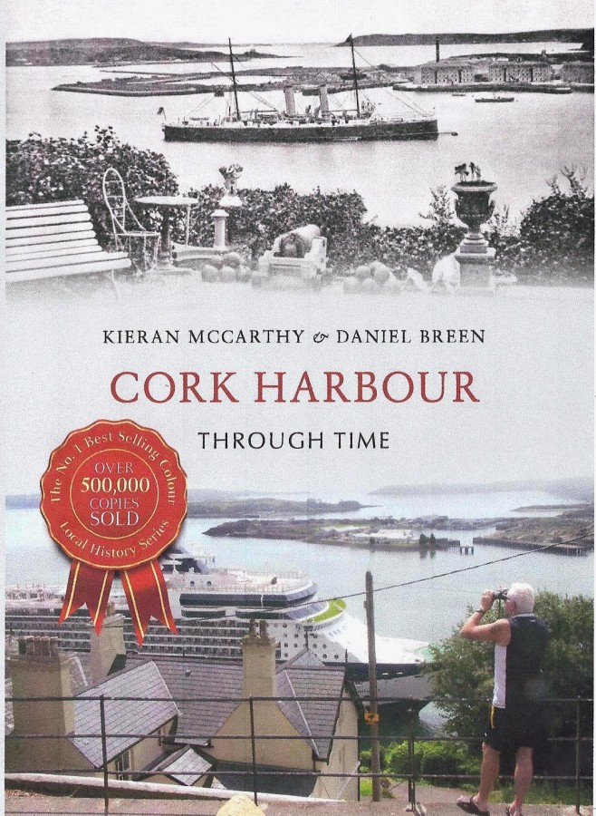
Cork Harbour Through Time

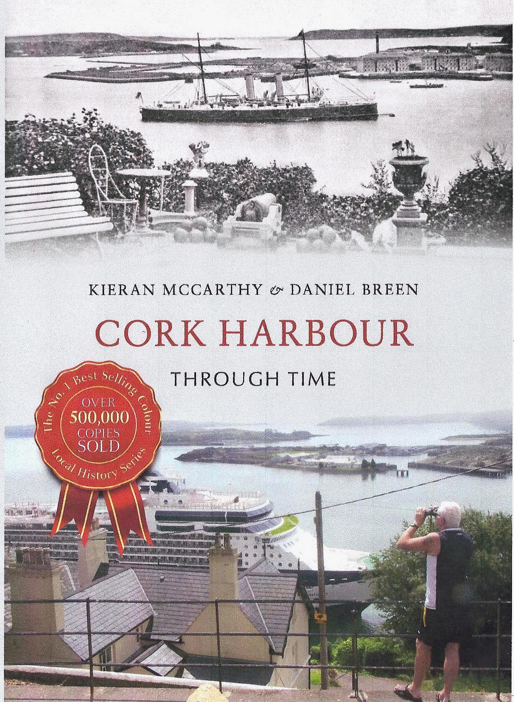
Cork Harbour Through Time

Ten Historical Items about Cork Harbour

(extracted from Kieran McCarthy’s and Dan Breen’s New Book)


  1. Dating back over 1,000 years to Viking times, from the Anglo-Norman time of a walled town to the present day, boats of all dimensions have been travelling through Cork’s riverine and harbour region, continuing a legacy of trade.


  1. Cork’s Marina, originally called the Navigation Wall, was completed in 1761. In 1820, Cork Harbour Commissioners formed and purchased a locally-built dredger. The dredger deposited the silt from the river into wooden barges, which were then towed ashore. The silt was redeposited behind the Navigation Wall. During the Great Famine, deepening of the river created jobs for 1,000 men who worked on creating the Navigation Wall’s road – The Marina.


  1. At one time, approximately fifty mansions in the south-eastern suburbs of Cork City overlooked Cork Harbour. One of the largest was that of Lakelands, owned by the Crawford family. By 1792, William Crawford Snr had moved from County Down to Cork, where he co-founded of the successful Beamish and Crawford brewery. He occupied a fine residence – Lakelands at Blackrock – to the east of the city, overlooking the widening River Lee.


  1. The imposing Blackrock Castle is the third structure on the site. The original fort (or castle) was built in 1582 by the citizens of Cork to safeguard ships against pirates, who would come into the harbour and steal away the vessels entering the harbour. In 1722 and 1827, the old tower was destroyed by a fire and a new one built.


  1. The history of fishing and fishermen in Blackrock dates back to the early 1600s. In 1911, sixty-four fishermen, ranging in age from fourteen to seventy, are listed in the census as living in Blackrock village and operating in and around the castle, Lough Mahon and harbour area.


  1. The District of Douglas village takes its names from the river or rivulet bearing the Gaelic word Dubhghlas or dark stream, which enters the tidal area nearby. As early as the late thirteenth century, King John of England made a grant of land to Philip de Prendergast near the city of Cork. On 1 June 1726, the building of the Douglas Factory commenced. Samuel Perry & Francis Carleton became the first proprietors.


  1. The Cork, Blackrock & Passage Railway opened in 1850, and was among the first of the Irish suburban railway projects. The original terminus, designed by Sir John Benson, was based on Victoria Road, but moved in 1873 to Hibernian Road (as shown above and now built upon). The entire length of track between Cork and Passage was in place by April 1850 and, within two months, the line was open for passenger traffic.


  1. With the establishment of a dock and shipyard in Passage West in the nineteenth century, many merchants became shipowners, and carried on an extensive trade in their own vessels. Three of these individuals were well-known entrepreneurs – William Parker (who engaged in foreign speculations in shipping), Thomas Parsons Boland and the Brown family.


  1. During the nineteenth century, many merchants in Passage West built their own big houses and terraces. This town recorded upwards of 100 covered cars called jingles engaged almost daily in the transport of people between Passage and Cork. Steamboats and several small boats also ploughed the waters between Cork and Passage several times daily.
  2. A letter from Vice-Adm. Thornborough of Trent, Cork Harbour, dated 28 August 1813, was read to the Ballast Board on 2 September 1813. In this letter he pointed out the danger vessels frequenting Cork Harbour were put in, as a result of the lack of a lighthouse at the entrance to the harbour. This small lighthouse was working by June 1817, but its tower was not conducive to a major harbour of refuge and port and, in 1835, it was replaced by the present larger tower.

Kieran’s New Book, Cork Harbour Through Time, November, 2014)

Cork Harbour Through Time By Kieran McCarthy and Dan Breen


   How do you capture a harbour in all its beauty? Being the second largest natural harbour in the world brings a focus and energy that Cork Harbour has always been open to. The ebb and flow of the tide through the ages has carved a unique landscape of cliffs, sand and gravel beaches that expose an underlining geology of limestone and sandstone. Invigorating this landscape are multiple monuments from different ages, many of which the postcards in Kieran McCarthy and Dan Breen seek to capture.

  Colourful villages provide different textures and cultural landscapes in a sort of cul-de-sac environment, with roads ending at harbours and car parks near coastal cliff faces and quaysides. The villages are scattered around the edges of the harbour, each with their own unique history, all connecting in someway to the greatness of this harbour. Walking along several junctures of fields, one can get the feeling you are at the ‘edge of memory’. There are the ruins of old structures that the tide erodes away. One gets the sense that a memory is about to get swept away by the sea, or that by walking in the footsteps trodden by photographers 100 years ago, one could get carried away by their curiosity. This new book tracks the space and historical context of 100 postcards in Cork Harbour, many of which were taken c. 1900–20.

Cork Harbour Through Time can be bought in many Cork bookshops.

Amazon: http://www.amazon.co.uk/Ireland-Europe-Countries-Regions-Books/s/ref=nb_sb_noss?url=node%3D279716&field-keywords=cork+harbour+through+time&rh=n%3A279716%2Ck%3Acork+harbour+through+time&ajr=1

Kieran’s New Book, Cork Harbour Through Time, 20 November 2014

Cork Harbour Through Time By Kieran McCarthy and Dan Breen

Kieran’s Our City, Our Town,

Cork Independent, 20 November 2014

Kieran’s New Book – Cork Harbour Through Time


     How do you capture a harbour in all its beauty? Being the second largest natural harbour in the world brings a focus and energy that Cork Harbour has always been open to. The ebb and flow of the tide through the ages has carved a unique landscape of cliffs, sand and gravel beaches that expose an underlining geology of limestone and sandstone. Invigorating this landscape are multiple monuments from different ages, many of which the postcards in my new book with Dan Breen seek to capture.

     Colourful villages provide different textures and cultural landscapes in a sort of cul-de-sac environment, with roads ending at harbours and car parks near coastal cliff faces and quaysides. The villages are scattered around the edges of the harbour, each with their own unique history, all connecting in someway to the greatness of this harbour. Walking along several junctures of fields, one can get the feeling you are at the ‘edge of memory’. There are the ruins of old structures that the tide erodes away. One gets the sense that a memory is about to get swept away by the sea, or that by walking in the footsteps trodden by photographers 100 years ago, one could get carried away by their curiosity. This new book tracks the space and historical context of 100 postcards in Cork Harbour, many of which were taken c. 1900–20.

     Many of the sites have been written extensively on over centuries, while others await proper exploration and critique. Chapter 1 begins in the city and takes the reader from Ireland’s southern capital of Cork City eastwards into the River Lee’s tidal estuary. This city is built on a shifting landscape of sand, gravel, rushes and reeds, a wetland knitted together to form a working port through the ages. In Cork City Through Time (2012), we showcased the old postcards of Cork City. Moving eastwards past the port, the river begins to spread in width, creating vast scenic vistas along areas like the marina, extending to the late seventeenth-century structure of Blackrock Castle and beyond, to the reed beds of Lough Mahon and Douglas Estuary. All are hidden places of beauty, much of which may be explored by the amenity walk along the old Blackrock & Passage Railway Line. When the line opened in 1850, it hosted 200,000 people in the first six months. In 1903, this line was later extended to Crosshaven. The resonances of such a venture are echoed along the walkway as old platforms, ivy clad stone-arch bridges provide legacies to admire. Passage, the first terminus for the railway, was once a shipbuilding centre of the south of Ireland. Nowadays, old quaysides and eerie, abandoned warehouses haunt the area. One can almost hear the hammers and whispers of workers’ repairing and patching together ocean-going ships. Further along the river, Monkstown provides insight into the past with its colourful Victorian mansions.

     The same can be said about the scenic wooded village of Glanmire, the iconic Father Mathew Tower and Fota House. All exist as rich storehouses of memory and are awe-inspiring to walk around at any time of the year. Chapter 2 takes the reader on a journey through some of the landscapes on Great Island, and naturally Cobh is a central focus. Drawn through several centuries and photographed since the invention of the camera, it is difficult not to be drawn to the town’s rich architectural steeple and exterior artwork on the late nineteenth-century construct of St Colman’s Cathedral. Cobh has stunning scenic quay vistas and a colourful selection of buildings. The town is also known for its stories of emigration and the legendary Titanic. One can feel its journey across the ocean and the role the town played in its part in the North Atlantic’s human history.

    The sites and spaces seen from Cobh’s specifically constructed building parapets are explored in Chapter 3. The harbour islands such as Spike Island and Haulbowline have histories dating back over 400 years. They were first fortified by star-shaped forts and secured for the expanding British Empire. Two more forts exist near the entrance to the Harbour, Camden Fort Meagher and Fort Davis. Originally built in the 1780s, one can explore the town’s military history and connections to a far-flung British empire through the harbour’s role in securing its might and power. However, one is humbled by stories of the Irish War of Independence and how these forts in time were secured by the Irish Government as Ireland’s last lines of defence. Today, these represent large community-based tourism projects.

    Chapter 4 explores the eastern shores of Cork Harbour. Here lies the great market town of Midleton, the old large malthouses of Ballincurra, the ancient tower at Cloyne, the quaint spaces within villages at Rostellan and Whitegate, and the ruins of old houses. Connect these with industrial projects such as Whitegate Oil Refinery, and family holiday centres such as Trabolgan, and all reveal rich stories. However, standing overlooking all within the harbour is the great lighthouse at Roches Point, warning ships of imposing rocks and providing a grand entrance gateway to the harbour. On a clear day, the views show a canvass of stories and memories.

Caption:

769a. Cork Harbour Through Time by Kieran McCarthy & Dan Breeen (published by Amberley Press, November 2014)


Kieran’s Our City, Our Town, 25 September 2014

761a. Recent sunny days in Fitzgerald's Park

Kieran’s Our City, Our Town Article,

Cork Independent

Discover Cork: Schools’ Heritage Project 2014-15

25 September 2014


Founded in the school year 2002/ 2003, the year 2014-15 coincides with the 12th year of the Discover Cork: Schools’ Heritage Project. Now launched for the new school term, The Project is open to schools in Cork; at primary level to the pupils of fourth, fifth and sixth class and at post-primary from first to sixth years. There are two sub categories within the post primary section, Junior Certificate and Leaving Certificate. A student may enter as an individual or as part of a group or a part of a class entry.


One of the key aims of the project is to allow students to explore, investigate and debate their local heritage (built, archaeological, cultural and natural) in a constructive, active and fun way. Projects on any aspect of Cork’s rich heritage can be submitted to an adjudication panel. Prizes are awarded for best projects and certificates are given to each participant. A cross-section of projects submitted from the last school season can be gleamed from www.corkheritage.ie plus there are other resources and entry information as well on this website.


 Students produce a project on their local area using primary and secondary sources. Each participating student within their class receives a visit and workshop from myself, the co-ordinator in October 2014. The workshop comprises a guide to how to put a project together. Project material must be gathered in an A4/ A3 size project book. The project may be as large as the student wishes but minimum 20 pages (text + pictures + sketches).  Projects must also meet five elements. Projects must be colourful, creative, have personal opinion, imagination and gain publicity before submission. These elements form the basis of a student friendly narrative analysis approach where the student explores their project topic in an interactive and task oriented way. In particular students are encouraged to attain primary material generating primary material through engaging with fieldwork, interviews with local people, making models, photographing, cartoon creating, making DVDs of their area. Re-enacting is also a feature of several projects.


 Since 2003, the project has evolved in how students actually pursue local history. The project attempts to provide the student with a hands-on and interactive activity that is all about learning not only about heritage in your local area (in all its forms) but also about the process of learning by participating students. The project is about thinking about, understanding, appreciating and making relevant in today’s society the role of our heritage- our landmarks, our oral histories, our scenery in our modern world for upcoming citizens. So the project is about splicing together activity on issues of local history and heritage such as thinking, exploring, observing, discovering, researching, uncovering, revealing, interpreting and resolving.


The importance of doing a project in local history is also reflected in the educational aims of the history curricula of primary and post-primary schools. Local heritage is a mould, which helps the student to become familiar with their local environment and to learn the value of it in their lives. Learning to appreciate the elements of a locality, can also give students a sense of place in their locality or a sense of identity. Hence the Project can also become a youth forum for students to do research and offer their opinions on important decisions being made on their heritage in their locality and how they affect the lives of people locally. Over the years, I know a number of students that have been involved in the project in schools over the years who have took their interest further and have gone on to become professional tour guides, and into other related college work.


The project is open to many directions of delivery. Students are pressed to engage with their topic -in order to make sense of it, understand and work with it. Students continue to experiment with the overall design and plan of their work. For example in general, students who have entered before might engage with the attaining of primary information through oral histories. The methodologies that the students create provide interesting ways to approach the study of local heritage. Students are asked to choose one of two extra methods (apart from a booklet) to represent their work. The first option is making a model whilst the second option is making a DVD. It is great to see students using modern up todate technology to present their findings. This works in broadening their view of approaching their project.


This project is kindly funded by Cork Civic Trust (viz the help of John X. Miller), Cork City Council (viz the help of Niamh Twomey), and the Heritage Council. Prizes are also provided by the Lifetime Lab, Lee Road and Sean Kelly of Lucky Meadows Equestrian Centre, Watergrasshill (www.seankellyhorse.com). Overall, the Schools’ Heritage Project for the last twelve years has attempted to build a new concerned generation of Cork people, pushing them forward, growing their self-development empowering them to connect to their world and their local heritage. Spread the word please. See my website, www.corkheritage.ie for more details and application forms.


Caption:

761a. Recent sunny days in Fitzgerald’s Park (picture: Kieran McCarthy)

Discover Cork: Schools’ Heritage Project, 2014/15


Cllr Kieran McCarthy is encouraging students in the Cork area to enter the Discover Cork: Schools’ Heritage Project, which has been launched for the 2014/ 15 school season. The Project, which is celebrating its twelfth year allows students to explore, investigate and debate their local heritage in a constructive, active and fun way. Interested students can pick any topic on Cork’s heritage to research and can participate as individuals, groups or as a class.  Students produce a project using primary material such as fieldwork, interviews, making models, DVDs of their area. 

Co-ordinator and founder of the project, Cllr Kieran McCarthy noted that “The project is about thinking about, understanding, appreciating and making relevant in today’s society the role of our heritage- our landmarks, our oral histories, our scenery in our modern world for upcoming citizens. So the project is about splicing together activity on issues of local history and heritage such as thinking, exploring, observing, thinking, discovering, researching, uncovering, revealing, interpreting and resolving. The Schools’ Heritage Project also focuses on motivating and inspiring young people, giving them an opportunity to develop leadership and self development skills, which are very important in the world we live in today.”


The City Edition of the Project is funded by Cork Civic Trust, Cork City Council, The Heritage Council, Evening Echo, Lifetime Lab, Sean Kelly of Lucky Meadows Equestrian Centre, Watergrasshill and Cllr Kieran McCarthy. Application forms to enter the project can be viewed on Cllr McCarthy’s heritage website, www.corkheritage.ie.

Kieran’s Our City, Our Town, 18 September 2014

760a. Summer rays, Fitzgerald's Park

Kieran’s Our City, Our Town Article,

Cork Independent, 18 September 2014

“Notes on a Park”


Finding myself sitting in Fitzgerald’s Park, creating a walking tour for culture night is engaging (Friday, 19 September, 5pm, at park stage, free). I observe my fellow but unknown companions, a woman reading a book while her young child plays with an imagined friend in the area by the Michael Collins statue, a man doing yoga by the river. In the distance two men sit on a bench by the pond chatting about aspects of life and children use the trees and bushes to create an imagined play world. Passing the Cork Museum there is the avid tourist with a map in her hand, entering to explore the wonders of Cork’s past.


On reflection the tourist’s map does not show the imaginary landscapes created in the mind of the people in the park. Indeed, the tourist’s map does not tell the real truth about the place. The reality is completely different. I recall reading once that maps are supposed to be an accepted part of everyday life and are a graphic representation of space. Maps have symbols – line spacings representing the lie of the land, perhaps the everydayness of a place – topography, water, road lengths, junctions, spot heights. In reality, those spacings are much different. Looking at a map of Fitzgerald’s Park, you never get that sense of sacredness, tranquillity, people coming and going, change and continuity, the whispered conversations to the outburst of laughter – a living place created by the human experience.


On my visit, I walk on, acknowledge and chat to a colleague about his research and travels in New Zealand. The pond with its Fr. Mathew Memorial fountain is imposing as the ducks hypnotically paddle around in a circle. My mind conjures up a memory, the trips with my parents, sister and brother to Fitzgerald’s Park, a haven of rest for many Corkonians and a familiar place of my childhood. Indeed, now growing older, thinking about jumping on the Shaky Bridge, feeding the birds in the pond and falling in, playing on the swings and slides and watching the world go by could be metaphors for time turning, a type of enjoying the moment but growing up and moving on. I have no doubt that I’m not the only Corkonian who has taken time out to appreciate the sacred composure of Fitzgerald’s Park and to use it to solve some of life’s problems.


With engaging with the historical development of the city, part of the process involves dealing with the familiar places like Fitzgerald’s Park that people know but also unravelling the narrative of the forgotten. Cork has many forgotten places that exist adjacent to well known cityscapes. Exploring these angles, I find that the notion of Cork as a city has always been reinvented. Exploring the architecture of Fitzgerald’s Park, there are elements that Cork has always been a cosmopolitan city within Western European culture, always staying in touch with aspects of modernisation, its history in a sense creating a worthy former European Capital of Culture. Looking at the physical landscape of the Park, there are clues to a forgotten and not so familiar past. The entrance pillars on the Mardyke, the Lord Mayor’s Pavilion, the museum, the fountain in the middle of the central pond dedicated to Fr Mathew and timber posts eroding in the river were once part of one of Cork’s greatest historical events, the Cork International Exhibitions of 1902 and 1903. Just like the magical spell of Fitzgerald’s Park, the Mardyke exhibitions were spaces of power. Revered, imagined and real spaces were created. They were marketing strategies where the past, present and future merged, Aesthetics of architecture, colour, decoration and lighting were all added to the sense of spectacle and in a tone of moral and educational improvement. The entire event was the mastermind of Cork Lord Mayor Edward Fitzgerald, after which the park got it name.


The wandering of my mind is broken by the crying of a child passing pining for an ice cream. It’s time to ramble on again. Passing by the famous swings and slides, they look so small to me now, as the parents and guardians nearby sit on the benches. Some stare into mid space, others chat and laughing, others shout and perhaps others remember their youthful spell within the Park. High above, the imposing Shaky Bridge stands as a testament of strength as a mother leaves her screaming children loose to jump on this great Cork institution. The River Lee, like the park’s pond, is hypnotic as it flows steadily towards the city centre past the familiar, forgotten, real and imagined spaces of one of Cork’s greatest landmarks Fitzgerald’s Park.


Other tour: I will also conduct a tour of the city side of the old line on Saturday evening, 20 September starting at 6.30pm (free) at the entrance on The Marina side adjacent the Main Drainage station of the Amenity Walk (as part of Cork Harbour Open Day). The Cork Blackrock and Passage Railway, which opened in 1850, was among the first of the Irish suburban railway projects.  Sir John Benjamin MacNeill, the engineer of the Cork Blackrock and Passage Railway, was appointed engineer-in-chief of many projects in Ireland including plans for 800 miles of railway.


Caption:

760a. Summer rays, Fitzgerald’s Park (picture: Kieran McCarthy)

Kieran’s Our City, Our Town, 28 August 2014

757a. Map of Dunlops plant, Centre Park Road, Cork, 1960 before expansion

Kieran’s Our City, Our Town,

Cork Independent, 28 August 2014

Technical Memories (Part 86) – Dunlops of the 1960s


“It is obvious that Cork in general and Dunlops and Fords, in particular do not fully share the views of a depressed future for our car-building industry. A very high percentage of Dunlop’s business is supplying original equipment to the assembly industry. All but a tiny fraction of the new vehicles have their wheels shod by tyres made in Cork. In any trading arrangement, which envisages completed cars being imported here with tyres already fitted of course, the consequences must be very serious for Dunlop” (journalist, Irish Press, 15 November, 1965, p.6).

With a £2m capital outlay for expansion revealed by the Irish Dunlop Company in early November 1965, two new giant industrial blocks were to be built in Dublin and Cork. The new office block at Cork comprised 48,000 square feet, spanning across six storeys and sitting on 130 piles into the Centre Park Road swamp. The new and modern-marketed building was to dominate the Marina Estate soaring over the one storey factory units. Irish materials were used in its construction. The Dunlops space was designed so that a computer centre, Cork’s first commercial computer, could occupy the whole of the ground floor. The proposed research staff were to be recruited from Irish universities, and were to begin work in Dunlop’s central division, located near Fort Dunlop, Birmingham. Initially 12 Irish university graduates were to be employed, but when the full programme developed, this figure was to increase to 30 graduates and ten assistants, who were to be located in the research laboratories part of the new administration block at the Marina. The Cork research centre was to carry out basic research for the central organisation.

In 1965, it was stated that the company’s payroll amounted to over £2m per year and total wages and salaries paid out in the previous 30 years exceeded £20 million. Payments by way of taxation, excise duty and local rates, in 1965 had reached a record level of nearly £900,000 (Irish Press, 12 November 1965, p.8). The Dunlops plan unveiled in November 1965 came 24 hours prior, T.J. Brennan, Managing Director of Fords, announced his company’s intention of spending £1 ½ million on major extensions to their assembly capacity (see previous articles).

The policy of the Irish Dunlop Company had always been to purchase its requirements of materials from Irish sources where practicable. On items such as textiles, packing materials and fuel and power, the company paid out almost £1m in 1965 to other Irish producers. The company hoped to increase its tyre exports to over 100,000 tyres – more than double the quantity for 1964. The firm in Cork was to amass a production area of 250,000 square feet and 125,000 square feet of storage. The firm had also just taken over the Irish Rubber Products factory at Waterford.

Fast forward to September 1967 and during a tour of the 17-acre Dunlops Plant at the Marina to journalists, E J Power, General Manager, expressed confidence in the future of the plant. He commented that if the Cork factory was to continue at maximum employment, which ran to more than 2,000 people, they would have to secure increased productivity. This would occur pending an improvement in the Irish economy, and an increase in exports, particularly to Britain where, where he added the motor industry was passing through a poor period. He explained that the Irish tyre market amounted to about one million tyres a year being exported to 58 countries. This was worth £6 ½ m to Dunlops and up to July 1966, Dunlops had 80 per cent of that market. Since then, imported tyres had cut into their business. Power to journalists noted of a large decline: “no one could have foreseen a few years ago, the slackening in world trade and consequently foreign tyre manufacturers had to get rid of their surpluses. Because our tyre market was small any influx of imports was bound to leave its effects…it will be necessary for us to rationalise still further over the next year, particularly in our non-tyre products but we will try and spread this and cushion it as humanly possible”. 

A press conference by Mr William Bailey, Director of European Operations, in early February 1969 and as reported by the Irish Independent (6 February 1969) commented Dunlops had 103 factories worldwide and 20 research units in five continents. In Europe, Mr Bailey pointed out that these were located in Britain, Ireland, France and Germany and, together employed nearly 40,000 people. Referring to the future growth of the market, he detailed that tyres were a growth industry throughout the world and that demand was growing at about 8 per cent per annum and Europe, as one of the major growth areas, accounts for about one-third of the world sales of car tyres and a quarter of truck tyre sales. Domestic European demand in 1967 was 100 million car tyres with probability of expansion by double by 1980.  His operations were planning to invest £40m into the European branches. He announced that a new tyre compounding department was to be built, costing over £1million, and that this would be in operation at Fort Dunlop in Birmingham.  

To be continued…

Caption:

757a. Map of Dunlops plant, Centre Park Road, Cork, 1960 before expansion (source: Claire Hackett).