Kieran’s Our City, Our Town Article,
Cork Independent, 10 July 2025
Making an Irish Free State City – A Guide to Cork Public Museum, 1945
The opening of the Cork Public Museum in April 1945 gave an important opportunity to showcase many archaeological and local history objects that had not an appropriate space to showcase them before. The souvenir booklet, published in 1945, makes for interesting reading as it not only contained a guide to artefacts on display in the re-opened museum, but also their local historical context. The layout of rooms in 1945 also remained the same for many decades before the construction of the Museum extension in 2005. Indeed some of the objects outlined below can still be viewed in the museum today.
The 1945 souvenir booklet noted that on the left as you entered the entrance vestibule of the museum, two relics of Cork of 200 years ago stood against the wall. The first was an inscribed stone, which was all that remained of the old North Shambles, or slaughter house. It bore the legend: “This Shambles was erected at the expense of Corporation Corke Anno DNI 1737. Thomas Farren Esqr Mayr. Dan Crone & Richd. Bradshaw Esgrs Sheriffs”.
On the right of the Shambles tablet was a window grille from the old North Gate Debtors’ Prison. The souvenir booklet highlights that it was found embedded high up in the back wall of No. 1 North Main Street when some reconstruction work was being done there in 1940. The North Gate Debtors Prison was built in 1715 during the Mayoralty of Phillip French. It replaced a larger gaol on the same site which had been a State prison. The grille weighed nearly 100 lbs and its bars were 1½ inches thick.
The souvenir booklet continues to outline that on a screen standing against the opposite wall was a series of illustrated newspaper cuttings of about one hundred years previous. These gave some interesting items of information relating to occurrences in Cork at that time.
On the left as you entered the hall from the vestibule was an exact replica of the well-known Cross of Cong. The replica belonged to the Honan Chapel, University College. It had been lent by kind permission of the President of the Honan Hostel Rev. J P Bastible, Dean of Residence and of Dr D McCarthy, Warden of the Hostel.
The key exhibition rooms were upstairs and the visitor was led in that direction. At the wall on the left as you approached the stairs was a geological exhibit, which showed something of the mineral resources of County Cork. At the opposite wall were a number of interesting relics of the Cork Butter Market. These included the scales on which were weighed the firkins that were sent to distant parts of the world.
At the back of the Hall facing the stairs were two inscribed stones which formed part of the plinth of the equestrian statue of George II (the George on horseback from which the Grand Parade gets its Irish name Sráid an Chapaill Bhuí), which formerly stood at the South Mall end of Grand Parade.
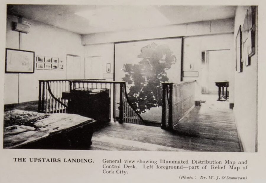
On the upstairs landing wall was a special permanent feature, which was designed to occupy the available space here. It took the form of a map of Ireland constructed in wood on a scale of one inch to two miles with buttons to push to light up on it highlighting heritage sites across Ireland. This was an innovative installation and one which many Cork children (including myself in time) had fun pressing buttons on for decades.
The souvenir booklet highlights what the map was trying to showcase; “Working in this medium, it is impossible to show every minor coastal indentation, and for this reason the outline has been slightly simplified. Affixed to its background which represents the sea, the land surface stands a quarter of an inch in relief. The whole feature measures overall 10’x 12’ and fills the large wall space on the stairway half-landing”.
As well as the principal rivers and lakes, the map showed 150 sites of historic and general interest, marked by small electric bulbs. The places selected for inclusion were divided into the following 12 groups, each group having a different colour of a bulb – ancient royal seats (light red), places connected with St Patrick (pink cross), Early Christian monasteries (dark red), cities founded by the Danes (light green), medieval monasteries (purple), medieval cathedrals (yellow), famous battles (orange), historic harbours (white), cities famous in history (yellow cross), famous Irish castles (dark green), boundary of the English Pale (blue), and birthplaces of famous people (yellow triangle).
The lights were controlled from a desk placed at the stair-head, and from this position the map could best be seen. Twelve switches, each with its group name below it, operated the bulbs and all twelve could be turned on together. The placenames on the map were given in Irish. Beside the switches, a card-index was provided, which gave descriptions of every site as well as a bibliography for those who may want to do further reading.
The souvenir booklet highlights that it was intended to add a further selection of sites to the map at a later date but because of the ongoing war it was difficult to attain the electrical equipment needed; “This would have been done in the first instance, but because of the difficulties of the present time [war], certain essential electrical equipment could not be obtained and the number of bulbs had therefore to be limited to the present figure. They are for the most part placed in the southern half of the country, since that area is of more interest to us; but when materials again become available, other areas will be more fully treated”.
On the walls around the landing, a selection of drawings, maps and photographs illustrated the places of greatest interest.
The souvenir booklet also described that the other exhibit, which found a place on the centre of the floor landing, was a large relief map of Cork city. This model, made from the Ordnance Survey 25% scale maps, was built by Mr Marshall Hutson, artist, for the Cork Agricultural and Industrial Fair of 1932. It was later acquired by University College. Where possible, it was overhauled and brought up to date and included some of the newly built suburbs. The line of the old Town Wall had also been added so as to show at a glance how the city had grown from its early small beginning.
To be continued…
Kieran’s historical walking tours for July 2025 (all free, 2 hours, no booking required)
Sunday 13 July 2025, Views from a Park – The Black Ash and Tramore Valley Park historical walking tour; meet at Half Moon Lane gate, 1pm.
Wednesday 16 July 2025, Cork Through the Ages, An Introduction to the Historical Development of Cork City; meet at the National Monument, Grand Parade, 6.30pm.
Thursday 17 July 2025, Sunday’s Well historical walking tour; discover the original well and the eighteenth century origins of the suburb, meet at St Vincent’s Bridge, North Mall end, 6.30pm.
Caption:
1312a. Picture of Map of Ireland constructed in wood with bulbs to light up, which highlighted heritage sites across Ireland, 1945 (picture: Cork Public Museum Souvenir Booklet, 1945).