Category Archives: Lord Mayor’s Work

Kieran’s Our City, Our Town 25 January 2024

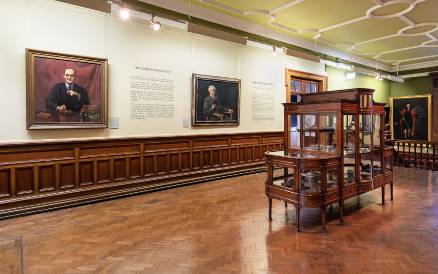
1237s. Cabinet of Gibson Bequest Curiosities, May 2019 (picture: Crawford Art Gallery, Cork. Photo: Jed Niezgoda).

Kieran’s Our City, Our Town Article,

Cork Independent, 25 January 2024

Making an Irish Free State City – The Gibson Bequest

The Crawford Art Gallery’s website leads with a focus of the gallery at present being positioned in a series of important heritage buildings, sections of which date back to the early eighteenth century right in the heart of Cork city. The gallery is in need of significant enhancement and upgrading to meet the evolving demands of a “dynamic national cultural institution”. Works are to begin this year to provide significant restoration value, new additional exhibition and public circulation areas, a new learn and explore facility, significant storage for the National Collection at Crawford, a new entrance, and a dramatically improved public realm.

There are many curios in the Crawford Art Gallery – its exquisite set of Antonio Canova sculptures and paintings within its collections make for great viewing and scholarly output. The gallery opened in 1885 and was built on the generous financial support of William Horatio Crawford.  The next generous sponsor has for the most part fallen out of Cork memory and that is the name of Joseph Stafford Gibson who provided finance through his will in creating the basis for a fund to buy paintings from 1919 onwards. The year 1924 – one hundred years ago – was a key year where the purchasing plan came into effect for the bequest.

Born near Kilmurray in 1837, Joseph inherited a small income which enabled him to devote his life to art studies. He went to Spain in 1878. and lived a lonely life in Madrid until his death in 1919. He was an artist and a collector of Works of art, and by all accounts had got together a comprehensive collection of paintings, prints, photographs, books, manuscripts, coins, antiques, and curios.

By Joseph’s will read in May 1919 he left £14,790 to the Crawford School of Art in Cork. Most of the legacy was to be spent in buying works of art for the Cork galleries, and to assist art students of special promise, who were of Munster birth, to travel and study in Europe. With this bequest, under wise direction from Irish experts, more than a hundred paintings in oils or water colour, and many drawings and sculptures have been acquired for the Cork gallery and are now on view there.

The Irish War of Independence and Civil War initially slowed down any processes of acquisition being put in place. It was to take almost five years before a strategic acquisition programmed was put in place.

One hundred years ago, on 15 January 1924 the Cork Examiner published the minutes of the Gibson Bequest sub-committee meeting of 14 January 1924. Draft regulations had been prepared by the Chairman Mr J J O’Connor setting out the procedure concerning the purchase of works of art under the terms of the bequest be approved. Enquiries had already been made regarding the acquisition of pictures by Jack Butler Yeats and Seán Keating. A painting entitled Sasha Kropotkin by Gerard Kelly of the Royal Hibernian Academy was to be purchased for £250. Gerard Kelly was an English painter in oil of portraits and landscapes. During his travels he painted some of his most characteristic figure studies. He became renowned for his portraits of elegant women, his technical genius and colourful, extensive subject matter. Sasha Kropotkin was the daughter of the anarchist, Prince Peter Kropotkin, and wife of the Russian revolutionary Boris Lebedev.

The draft Gibson Bequest regulations regarding the purchase of works of art were set out as follows: Purchases needed to be confined to the original works in the following: (a) oils, (b) water colours, (c) pastel, (d) drawings or studio» in chalk, pencil, crayon or pen and ink, (a) etchings, (f) wood cuts, (g) silver point, (n) dry point, (i) mezzotint, (j) sculpture, but that it be the rule not to purchase works in plaster, unless in exceptional circumstances, on account of intrinsic merit, and then only with the intention of having them cast in permanent material; (k) decorative art, e.g. goldsmiths and silversmith’s work, stained glass and wood-carving.

No purchase could be made by the committee which was not approved by selected advisers or a majority of such. Such advisers could be selected for the special purpose to be sent to exhibitions at the great art centres to select works for purchase under the terms of the bequest. Advisors were to submit a signed report with all recommendations for the purchase of works of art. Purchases were to be as far as possible in sequence, as portrait, subject picture, landscape, and sculpture. The recommendations of the advisors with respect to any purchase were to be subject to the approval of the Gibson Bequest sub-committee.

The Chairman J J O’Connor noted at the meeting that the intention of the committee was to make their gallery a real first-class art gallery through making purchases of first class specimens.

As the years progressed, paintings from British and French contemporary artists were bought and now form part of the core of the collections of the Crawford Art Gallery. Local artists were also enabled to travel afield to such artist hubs such London, Madrid, Paris and Rome.

Indeed, an article the Cork Examiner for 27 June 1928 notes the acquisition of many works arising from the Gibson Bequest from artists such as William G Barry, Philip Connard, Hughes de Beaumont, John Arnesby Brown, James Humbert Craig, Edward Montgomery O’Rorke Dickey, Norman Garstin,  Nathaniel Grogan, Paul Henry, Nathaniel Hone, Seán Keating, Gerald F Kelly, Frank McKelvey, Sir John Lavery, William John Leech, Daniel McDonald, David Muirhead, Diarmuid O’Brien, Walter F Osbourne, Miss Annie St J Partridge, David Richter, Algernon Talmadge, Henry Jones Thaddeus, David Albert Veresmith and Leo Whelan. Many of the artists above were household names in the early twentieth art world in Britain and Ireland.

Caption:

1237s. Cabinet of Gibson Bequest Curiosities, May 2019 (picture: Crawford Art Gallery, Cork. Photo: Jed Niezgoda).
Kieran’s Our City, Our Town, 18 January 2024

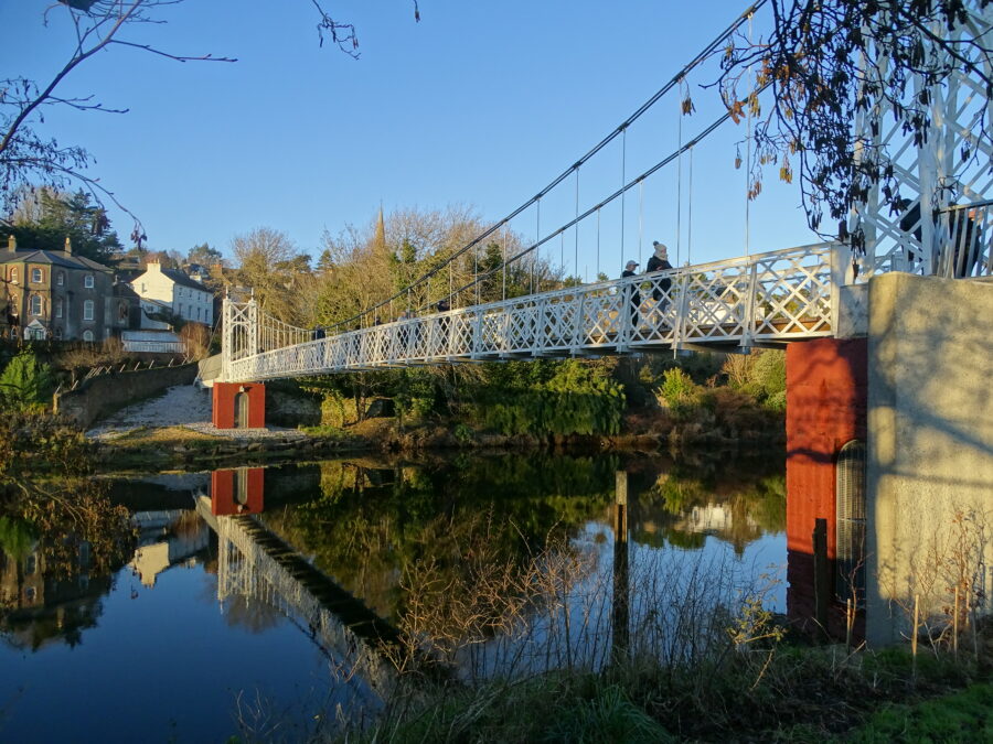
1236a. Daly's Bridge aka Shaky Bridge, present day, which is one of the featured bridges in Kieran's audio heritage trail of the Bridges of Cork (picture: Kieran McCarthy).
1236a. Daly’s Bridge aka Shaky Bridge, present day, which is one of the featured bridges in Kieran’s audio heritage trail of the Bridges of Cork (picture: Kieran McCarthy).

Kieran’s Our City, Our Town Article,

Cork Independent, 18 January 2024

Kieran’s Audio Heritage Trails

January generally coincides with some fine and cold cold days where walking the city is lit up by wintry Atlantic light. As someone who enjoys photographing the city, it is a good time of year to capture some of the city’s nuanced layers of its past. I hope to launch my physical walking tours again in April but in the meantime, check out my audio heritage trails, which have been developed with Meitheal Mara – on the Bridges of Cork and The Marina respectively.

Both audio trails are hosted on my website www.corkheritage.ie under the history trails section. All you need is your smartphone and some headphones. The first audio trail provides insights into the histories of the Cork city centre’s bridges, their place in Cork and some of their surrounding histories. The walk around the bridges is just over two hours in duration. The trail is clockwise from South Gate Bridge up the south channel and down the north channel to cross back to the south channel. It ends at Nano Nagle Bridge.

They say the best way to get to know a place is to walk it. Through many centuries Cork has experienced every phase of Irish urban development. It is a city you can get lost in narrow streets, marvel at old cobbled lane ways, photograph old street corners, gaze at clues from the past, engage in the forgotten and the remembered, search and connect for something of oneself, and thirst in the sense of story-telling – in essence feel the DNA of the place. With so many layers of history in Cork, there is much to see on any walk around Cork City and its respective neighbourhoods. The River Lee has had and continues to have a key role in the city’s evolution.  Many Corkonians and visitors have crossed over the River Lee’s bridges and have appreciated the river’s tranquil and hypnotic flow.

The audio trail begins at the oldest of the city’s bridges – that of South Gate Bridge. In the time of the Anglo Normans establishing a fortified walled settlement and a trading centre in Cork around 1200 AD, South Gate Drawbridge formed one of the three entrances – North Gate Bridge and Watergate being the others. A document for the year 1620 stated that the mayor, Sheriff and commonality of Cork, commissioned Alderman Dominic Roche to erect two new drawbridges in the city over the river where timber bridges existed at the South Gate Bridge and the other at North Gate.

In May 1711, agreement was reached by the Council of Cork Corporation that North Gate Bridge would be rebuilt in stone in 1712 while in 1713, South Gate Bridge would be replaced with a stone arched structure. South Gate Bridge still stands today in its past form as it did over 300 years ago apart from a small bit of restructuring and strengthening in early 1994.

The second of the new audio trails is on The Marina. A stroll down The Marina is popular by many people. The area is particularly characterized by its location on the River Lee and the start of Cork Harbour. Here scenery, historical monuments and living heritage merge to create a historical tapestry of questions of who developed such a place of ideas. Where not all the answers have survived, The Marina is lucky, that archives, newspaper accounts, census records and old maps and other insights have survived to showcase how the area and the wider area has developed. These give an insight into ways of life and ambitions in the past, some of which can help the researcher in the present day in understanding The Marina’s evolution and sense of place going forward.

Cork’s Marina was originally called the Navigation Wall or in essence it was a guidance or tracking wall to bring ships into Cork City’s South Docks area. It was completed in 1761.

Following the constitution of the Cork Harbour Commissioners in 1814 and their introduction of steam dredging, a vigorous programme of river and berth deepening, quay and wharf building commenced. The dredger of the Cork Harbour Commissioners deposited the silt from the river into wooden barges, which were then towed ashore. The silt was re-deposited behind the Navigation Wall.

During the Great Famine, the deepening of the river created jobs for 1,000 men who worked on widening the physical dock of the Navigation Wall. In essence a fine road was constructed, which linked into Cork’s South Docks. To give an aesthetic to the new road, a fine row of elm trees was planted c.1856 by Prof. Edmund Murphy of Queen’s College Cork (now UCC). The elm trees were part of a crop and tree growing experiment.

In 1870, the Gaelic poet and scholar Donncha Ó Floinn put forward to the Improvements Committee of Cork Corporation that the new road of the Navigation wall be named Slí na hAbhann, which means the ‘pathway by the river’. Ó Floinn’s proposal was not accepted. The matter came before the Improvements Committee again in 1872. This time Ó Floinn suggested that the promenade be named ‘The Marina’. He outlined that ‘The Marina’ was the name allocated to a recently reclaimed piece of land near Palermo in Sicily. In July 1872, Cork Corporation formally adopted ‘The Marina’ as the name of the new road or promenade.

Listen to Kieran’s audio heritage trails under history trails at www.corkheritage.ie

Captions:

1236a. Daly’s Bridge aka Shaky Bridge, present day, which is one of the featured bridges in Kieran’s audio heritage trail of the Bridges of Cork (picture: Kieran McCarthy).

Kieran’s Our City, Our Town, 11 January 2024

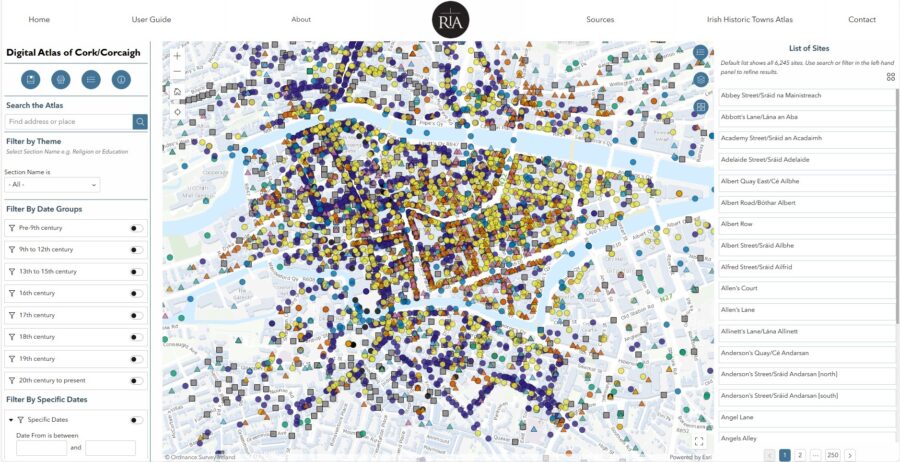
1235a. Screen grab of the Digital Atlas of Cork.

Kieran’s Our City, Our Town Article,

Cork Independent, 11 January 2024

The New Digital Atlas of Cork

They say the best way to get to know a city is to walk it – and in these early January days it is an ideal time. In Cork you can get lost in narrow streets, marvel at old cobbled lane ways, photograph old street corners, look up beyond the modern shopfronts, gaze at clues from the past, be enthused and at the same time disgusted by a view, smile at interested locals, engage in the forgotten and the remembered, search and connect for something of oneself, thirst in the sense of story-telling – in essence feel the DNA of the place.

Giving walking tours for over 30 years has allowed me to bring people on a journey into that soul but also receive feedback on the wider contexts of what visitors and locals have seen elsewhere. Cork is a city packed with historic gems all waiting to be discovered at every street corner.

Cork has a soul, which is packed full of ambition and heart. Cork’s former historic networks and contacts are reflected in its the physical urban fabric – its bricks, street layout and decaying timber wharfs. Inspired by other cities with similar trading partners, it forged its own unique take on port architecture.

So the new Digital Atlas of Cork/ Corcaigh is very welcome. It is one of a series of digital atlases created by the Irish Historic Towns Atlas team (the others are Derry, Dungarvan and Galway). The Digital Atlas of Cork/Corcaigh is an initiative of the Digital Working Group of the Irish Historic Towns Atlas research programme. The project has been led by Sarah Gearty (Royal Irish Academy) and Rachel Murphy (University of Limerick), with Mani Morse (Dublin City University) as Digital Manager. 

The Digital Atlas of Cork/Corcaigh is a free online interactive map that invites you to discover the built heritage of Cork City in a new way where 6,245 features of the city’s history from AD 623 to 1900 are mapped. The atlas includes descriptions of over 800 streets, including their names in Irish and English as well as historical variants.

Users can browse the digital atlas or search for a specific site in the city. They can also select and view features associated with specific time periods, from medieval times to the present day. Most notably, it maps out Cork’s earlier historical sites especially around South and North Main Street and its Viking age history and Anglo Norman history.

Each historical feature is represented by a coloured symbol, each feature has been categorized into one of eleven different themes such as entertainment, manufacturing, religion and transport. When a user clicks on a feature, key information about it is displayed in a pop-up box. 

A specially commissioned historical map depicts each individual house and plot during the mid-nineteenth century (1842). This is just one of a number of layered maps that may be switched on and off to show how the city developed over the centuries. 

Other layers include Ordnance Survey maps — a present-day plan of the city, as well as historic maps showing Cork pre-Great Famine and at the turn of the twentieth century. Additional map layers will be released over the coming months, providing access for the first time to digitised town plans by the Ordnance Survey (1842) and Valuation Office (1852–64). 

A downloadable user guide has been created to accompany the resource, to allow anyone to explore the Digital Atlas with further education and project work in mind. The project has been part funded by the Heritage Council Stewardship Fund 2023. It has been supported by partners Cork City Council, the Digital Repository of Ireland, the National Archives of Ireland and Táilte Éireann.

The Digital Atlas is remarkable with over 6,000 entries. It is a tremendous new resource for all the people of Cork and will no doubt instil a sense of pride in local communities, through its use in schools and libraries. In particular, the research and further reading aspect of the atlas will be a great source for anyone with an interest in the history and development of Cork City. This innovative project from the Royal Irish Academy will make the valuable research of the Irish Historic Towns Atlas series available to a wider and more varied audience than heretofore.

The atlas will contribute immensely to the work of Cork City Council and the wider professional community in Cork particularly those working in archives, museums, education, planning, architecture and conservation. Ciara Brett, City Archaeologist, Cork City Council noted of the Digital Atlas:

 “The Digital Atlas, when utilised with the forthcoming printed Atlas, will be a great benefit to the study of the changing urban environment and will provide practical assistance in the preparation and implementation of planning policy and development management in the City. The IHTA Cork/Corcaigh volume in digital format will add to the existing corpus of published material and will, I believe, encourage future research and study that will enhance our understanding and appreciation of our city”.

The Digital Atlas of Cork/Corcaigh is based on research carried out for Irish Historic Towns Atlas, no. 31, Cork/Corcaigh by Howard B Clarke and Máire Ní Laoi, which will be published by the Royal Irish Academy in print in May 2024. 

Based at the Royal Irish Academy, the Irish Historic Towns Atlas research programme traces the topographical development of towns, cities and suburbs through its atlas and ancillary publications, annual seminars and special exhibitions. It is part of a wider international scheme that covers nineteen countries. The Irish programme is considered a leader in the development of digital atlases of this kind.

For more log onto www.ria.ie/digital-atlas-corkcorcaigh

Caption:

1235a. Screen grab of the Digital Atlas of Cork.

Kieran’s Lord Mayor’s Column, 6 January 2024

Discover Cork Through a New Digital Atlas:

  They say the best way to get to know a city is to walk it – and a new year with crisp early January days is an ideal time. In Cork you can get lost in narrow streets, marvel at old cobbled lane ways, photograph old street corners, look up beyond the modern shopfronts, gaze at clues from the past, be enthused and at the same time disgusted by a view, smile at interested locals, engage in the forgotten and the remembered, search and connect for something of oneself, thirst in the sense of story-telling – in essence feel the DNA of the place.

Giving walking tours for over 30 years has allowed me to bring people on a journey into that soul but also receive feedback on the wider contexts of what visitors and locals have seen elsewhere. Cork is a city packed with historic gems all waiting to be discovered at every street corner.

Cork has a soul, which is packed full of ambition and heart. Cork’s former historic networks and contacts are reflected in its the physical urban fabric – its bricks, street layout and decaying timber wharfs. Inspired by other cities with similar trading partners, it forged its own unique take on port architecture.

So the new Digital Atlas of Cork/ Corcaigh is very welcome. It is one of a series of digital atlases created by the Irish Historic Towns Atlas team (others are Derry, Dungarvan and Galway). The Digital Atlas of Cork/Corcaigh is an initiative of the Digital Working Group of the Irish Historic Towns Atlas research programme. The project has been led by Sarah Gearty (Royal Irish Academy) and Rachel Murphy (University of Limerick), with Mani Morse (Dublin City University) as Digital Manager. 

The Digital Atlas of Cork/Corcaigh is a free online interactive map that invites you to discover the built heritage of Cork City in a new way where 6,245 features of the city’s history from AD 623 to 1900 are mapped. The atlas includes descriptions of over 800 streets, including their names in Irish and English as well as historical variants.

View the atlas here: Digital Atlas of Cork/Corcaigh | Royal Irish Academy (ria.ie)

Users can browse the digital atlas or search for a specific site in the city. They can also select and view features associated with specific time periods, from medieval times to the present day. Most notably, it maps out Cork’s earlier historical sites especially around South and North Main Street and its Viking age history and Anglo Norman history.

Each historical feature is represented by a coloured symbol, each feature has been categorized into one of eleven different themes such as entertainment, manufacturing, religion and transport. When a user clicks on a feature, key information about it is displayed in a pop-up box. 

A specially commissioned historical map depicts each individual house and plot during the mid-nineteenth century (1842). This is just one of a number of layered maps that may be switched on and off to show how the city developed over the centuries. 

Other layers include Ordnance Survey maps — a present-day plan of the city, as well as historic maps showing Cork pre-Famine and at the turn of the twentieth century. Additional map layers will be released over the coming months, providing access for the first time to digitised town plans by the Ordnance Survey (1842) and Valuation Office (1852–64). 

A downloadable user guide has been created to accompany the resource, to allow anyone to explore the Digital Atlas with further education and project work in mind. The project has been part funded by the Heritage Council Stewardship Fund 2023. It has been supported by partners Cork City Council, the Digital Repository of Ireland, the National Archives of Ireland and Tailte Éireann.

The Digital Atlas is remarkable with over 6,000 entries. It is a tremendous new resource for all the people of Cork and will no doubt instil a sense of pride in local communities, through its use in schools and libraries. In particular, the research and further reading aspect of the atlas will be a great source for anyone with an interest in the history and development of Cork City. This innovative project from the Royal Irish Academy will make the valuable research of the Irish Historic Towns Atlas series available to a wider and more varied audience than heretofore.

The atlas will contribute immensely to the work of Cork City Council and the wider professional community in Cork particularly those working in archives, museums, education, planning, architecture and conservation. Ciara Brett, City Archaeologist, Cork City Council noted of the Digital Atlas:

 “The Digital Atlas, when utilised with the forthcoming printed Atlas, will be a great benefit to the study of the changing urban environment and will provide practical assistance in the preparation and implementation of planning policy and development management in the City. The IHTA Cork/Corcaigh volume in digital format will add to the existing corpus of published material and will, I believe, encourage future research and study that will enhance our understanding and appreciation of our city”.

The Digital Atlas of Cork/Corcaigh is based on research carried out for Irish Historic Towns Atlas, no. 31, Cork/Corcaigh by H.B. Clarke and Máire Ní Laoi, which will be published by the Royal Irish Academy in print in May 2024. 

Based at the Royal Irish Academy, the Irish Historic Towns Atlas research programme traces the topographical development of towns, cities and suburbs through its atlas and ancillary publications, annual seminars and special exhibitions. It is part of a wider international scheme that covers nineteen countries. The Irish programme is considered a leader in the development of digital atlases of this kind.

Kieran’s Our City, Our Town, 4 January 2023

Kieran’s Our City, Our Town Article,

Cork Independent, 4 January 2024

Past Projections into the Future

The more one studies the vast stories at play in Cork City, the more they pull you in to study them more. The more they pull you in the more one gets under the skin of our historic city; one becomes even more enamoured by the rake of very interesting stories, which created our beautiful city.

In recent months one interesting project in the guise of Island City Sculpture Trail, has harnessed Cork’s urban environment and its heritage and history to bring art to the streets of Cork. The temporary artworks are located on Carey’s Lane, the Exchange Building on Princes Street, Cook Street, Cornmarket Street and soon at Triskel Christchurch.

Island city Sculpture Trail at its heart reflects on how lucky we are in Cork to have a wider heritage and historical contexts, which all add to Cork’s a strong sense of memory and a strong sense of place.

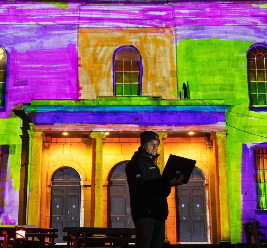
Tempus Futurum by Brian Kenny is a light projection onto Triskel Christchurch that takes viewers on a journey through the building’s rich history, present and future. Brian is a video artist and projection mapping specialist whose work focuses on the transformation of environments through the manipulation of lighting and video technology.  His video and projection mapping work spans all formats of presentation from contemporary galleries to large-scale outdoor productions.  He is the founder and Creative Director of Lightscape Visuals, an award-winning studio specialising in projection mapping, live visuals and immersive and interactive environments.

On the historic South Main Street there is an abundance of stories, memories, and curiosities. It is a former rushes and reeds swampland. On top of that a Hiberno-Norse settlement grew. Some of their foundational timber structures still exist and are so compacted beneath the ground because of our pressure on them. It was they who also built the first South Gate Bridge – a flimsy timber structure, which has changed at least four-five times over the past thousand years.

South Main Street became a former impressive street of the walled town of Cork, whose width was originally probably about three metres and where light onto the street was limited.

Christ Church is the fourth building on the site for Christ Church over the past 1,000 years. It’s current crypt hosting names of families from 17th and 18th century Cork whose names are embedded in street names – for example Tuckey Street.

South Main Street is a street that had once was one of the largest breweries in the South of Ireland in the guise of Beamish and Crawford. It is a street where arches such as those on the southern end of Bishop Lucey Park highlight one of the largest clothing companies in 19th century in the guise of Lyons Clothing Company.

Bishop Lucey Park, soon to be revamped with its impressive array of monuments, hosts a piece of the town wall of Cork’s Anglo-Norman walled town to a 1798 rebellion memorial, and boxing memorials. The park is a nod to the 800th anniversary of Cork becoming an official market place complete with a mayor, councillors and sheriffs.

The list of historical stories goes on – the story of the debtor’s prison, the story of Hanover Street and the House of Hanover connection, the story of Lane’s Brewery, the story of the Wide Street Commission, the earlier nineteenth yellow slob brick from Douglas Estuary in the current buildings on the street, the story of the naming of George Washington Street, the story of the Triskel Arts Centre, and the story of the Sir Henry’s Night Club. South Main Street is very fortunate to have such heritage, history and memory.

Brian Kenny’s remarkable, digitally mapped, moving image artwork is projected onto the South Main Street façade of the Christ Church, which is over 300 years old. Each evening from dusk, for up to seven months a year, the captivating 10-minute looped moving visuals will be projected for all to enjoy.  

Tempus Futurum is inspired by the motto “A society thrives when elders plant trees under whose shade they’ll never rest”. It delves into past, present, and an imminent future, exploring human impact on the environment.

Amidst this journey, the perspectives of 50 local schoolchildren breathe life into the projection, offering reflections on the building’s future. Their youthful imaginations visualise a world shaped by present actions – a reminder that our choices today echo into tomorrow’s legacy.

Beginning with a interpretation of unharmed forests untouched by humanity, the first scene evokes the beauty of nature in its untouched form. Transitioning, the arrival of human settlement marks a central juncture, signalling the beginning of cultivation and humanity’s imprint on the landscape – a forerunner to the city’s birth.

Brian invites reflection into one’s relationship with the location and the city’s evolution. The artwork stresses that even in the face of an uncertain future, our actions echo – a testament to the legacy we leave for generations yet to come.

Brian notes of his narrative: “As viewers immerse themselves in this thought-provoking narrative, they become integral threads in the tapestry of time, realising that our relationship with our surroundings isn’t solitary but part of an enduring continuum—a reminder that our choices today shape the shadows cast upon the landscapes of tomorrow”.

Read more on: www.corkcity.ie/en/island-city-cork-s-urban-sculpture-trail

Happy New Year to all readers.

Caption:

1234a. Artist Brian Kenny at Tempus Futurum at Triskel ChristChurch, December 2023 (picture: Cork City Council).

Happy Christmas

The Blessing of a Candle

by Lord Mayor of Cork Cllr Kieran McCarthy

Sturdy on a table top and lit by youngest fair,
a candle is blessed with hope and love, and much festive cheer,
Set in a wooden centre piece galore,
it speaks in Christian mercy and a distant past of emotional lore,

With each commencing second, memories come and go,
like flickering lights on the nearest Christmas tree all lit in traditional glow,
With each passing minute, the flame bounces side to side in drafty household breeze,
its light conjuring feelings of peace and warmth amidst familiar blissful degrees,

With each lapsing hour, the residue of wax visibly melts away,
whilst the light blue centered heart is laced with a spiritual healing at play,

With each ending day, how lucky are those who love and laugh around its glow-filledness,
whilst outside, the cold beats against the nearest window in the bleak winter barreness,
Fear and nightmare drift away in the emulating light,
both threaten this season in almighty wintry flight,

Sturdy on a table top and lit by youngest fair,
a candle is blessed with hope and love, and much festive cheer.

Kieran’s Lord Mayor Column, The Echo, 23 December 2023

Island City, Cork’s New City Sculpture Trail:

Island City Sculpture Trail is the most ambitious arts project Cork City Council has undertaken and the single biggest investment in public art our city has ever seen. I was delighted to meet all of the inspiring artists and architects, at their individual unveilings over the past few months, and to hear the incredible thinking, ambition, motivations, process, detail and love that has gone into each installation.

Cork City Council would like to sincerely thank our partners Fáilte Ireland, who funded the project under the Urban Animation Scheme, and the National Sculpture Factory for commission support.

The trail has been a great project for all, bringing art to the streets of Cork and enriching our urban environment and its heritage and history. In fact, it is a testament to the resilience, creativity and togetherness of the cultural sector. This initiative will deepen the city’s connection with public art and encourage locals and visitors to explore new areas of the city as art comes to life on our streets. The trail will be in situ for the next five years.

The temporary artworks are located on Carey’s Lane, the Exchange Building on Princes Street, Cook Street, Cornmarket Street and soon at Triskel Christchurch.

Sentinels (flew through the ages in the shape of birds) by artist Niamh McCann is a lane-length sculptural piece influenced by the architecture, geography, and incidental features along the length of Carey’s Lane in Cork city centre. The work is fixed above head height on the lane and is held by the simple image of a seagull, perched atop a neon strip, sentinel-like on either end of Carey’s Lane. The sculpture is intended to be intriguing and playful, animating the lane by day and by night – a work that is both intimate and dynamic and responds to the shifting shape of the city.

Sentinels’ is a nod to the old and the new – from Cork City’s diverse and migratory history and its merchant and yachting tradition to its welcoming of new cultures and its urban adaptability. Using a combination of contemporary materials and craft, the installation explores the themes of travel and landscape and draws a line from one end of the lane to the other.

The artist was also influenced by the inhabitants and geography of the lane such as the history of craft, culture and the presence of the Huguenot graveyard. Niamh worked with sustainable materials that work well in outdoor settings such as bronze, jesmonite, and cedar wood. The red rope that links the pieces is a nod to the Rebel county’s traditional colour.

The Face Cup by artist Fiona Mulholland is a celebration of the county’s rich prehistoric heritage. The artworks populate the facade of the historic Exchange Building on the corner of Princes Street and Oliver Plunkett Street.

Linking the past to the present, Fiona’s artwork of large-scale sculptural reliefs is based on a collection of exceptional Bronze Age ceramic artefacts – a small clay cup decorated with eyes, nose, ears and feet, another pottery vessel with ears and a spoon dating approximately 3800 years old. The original artefacts were excavated by archaeologists working on the site of the N8/N73 Mitchelstown Relief Road in 2004, who have assisted Fiona with ensuring accuracy for the project. The artworks are handmade in styrofoam and fibreglass to keep them light-weight and painted gold as a nod to our Bronze Age heritage.

Boom Nouveau by collaborative practice Forerunner can be viewed on Cook Street. The sculpture mimics the form of a tangible everyday urban street feature – the lamp post. The name Boom Nouveau refers to the rupture of the artwork emerging from the ground, with a nod to the influence of the craftsmanship of art nouveau.

The piece reintroduces an air of mystery and possibility into our surroundings. The effect is achieved by using familiar building materials and adding in artistic elements such as hand blown glass and cast bronze.

Urban Mirror on Cornmarket Street (Coal Quay) by plattenbaustudio is a beautifully crafted large table with an atmospheric light that will provide a sculptural pavilion in a cultural corner of the city centre. It is inspired by the street’s vibrant history as a market place, and the current weekly Saturday Street Market from 10am-12pm. Made of durable and playful stainless steel, it has 16 fixed chairs and can seat up to fifty people. Its reflective nature will also light the square on a bright day. The elevated ball in the centre provides a focus from all directions. As the sun sets it will light up, giving a warm glow to the area.

Designed by architects Jennifer O’Donnell and Jonathan Janssens, and fabricated by Sara Murphy and Frank Prendergast of Space Forms Ltd. Urban Mirror is intended to be a space used by the public.

Tempus Futurum by Brian Kenny is a light projection on the Triskel Christchurch, that takes viewers on a journey through the building’s rich history, present and future. 

The remarkable, digitally mapped, moving image artwork is projected onto the South Main Street façade of the Georgian building, which is over 300 years old. Each evening from dusk, for up to seven months a year, the captivating 10-minute looped moving visuals will be projected for all to enjoy.  

Tempus Futurum is inspired by the motto “A society thrives when elders plant trees under whose shade they’ll never rest”. It delves into past, present, and an imminent future, exploring human impact on the environment.

Amidst this journey, the perspectives of 50 local schoolchildren breathe life into the projection, offering reflections on the building’s future. Their youthful imaginations visualise a world shaped by present actions – a reminder that our choices today echo into tomorrow’s legacy.