Voices of Cork, Artwork to the Swifts, January 2024
Voices of Cork, Like Grandparents in Fairytales, 21 January 2024
Kieran’s Article, Place Matters in Cork, Irish Examiner, 21 January 2023
It is thirty years since I gave my first walking tour across the flat of Cork City and penned my first history project on the city. Cork is a great story to research and to tell. One cannot but be pulled into the multitudes of narratives, which have framed Ireland’s southern capital. I have really enjoyed researching and promoting Cork’s story.
Cork’s place and story has been carved over many centuries and all those legacies can be found in its narrow streets and laneways and in its built environment. The legacy echoes from being an old ancient port city where Scandinavian Vikings plied the waters 1,000 years ago – their timber boats beaching on a series of marshy islands – and the wood from the same boats forming the first foundations of houses and defences.
We will never know and will always speculate upon their raison d’être to construct such a settlement upon a wetland. Themes of survival, community life living on the edge, ambition, innovation, branding and internationalisation are etched across the narratives of much of Cork’s built heritage and are amongst my favourite topics to research. Indeed, I fully believe that these are key narratives that Cork needs to break the silence on more.
However, for all the tours and for all the writing projects, I still seek to figure out what makes the character of Cork tick. I still read between the lines of historic documents, archives and placenames. I get excited by a nugget of information, which completes a historical puzzle I might have started years ago. I have sat in the library pouring over a book or old newspaper on many an occasion trying to figure out where a piece of information sits in my researches.
I still look up at the architectural fabric of the city and at name plaques to seek new discoveries, hidden treasures and new secrets. I encourage people on my tours to look up and around and always they see something that I have not seen. I am still no wiser in teasing out all of Cork’s biggest secrets. But I would like to pitch that it’s biggest secret is itself, a charming urban landscape, whose greatest secrets have not been told and fully explored. In essence Cork has a living heritage and history, which defines it.
I have articulated over the years that there is a power of place – that the concept of place matters. Cork is a place of tradition, continuity, change and legacy. It is a place of direction and experiment by people, of ambition, experiences and learning, of ingenuity and innovation and a place of nostalgia and memory.
Cork’s urban landscape is filled with messages about the past – from positive to negative. That beyond the physical surfaces of a city such as Cork, there is a soulful and evocative character etched across the flat of the city, the estuary of the river Lee and surrounding valleysides.
Place matters in Cork. Within this topographical frame is a heritage – physical and spiritual to a degree – that needs to be minded, cherished and nourished for the Cork of the future.
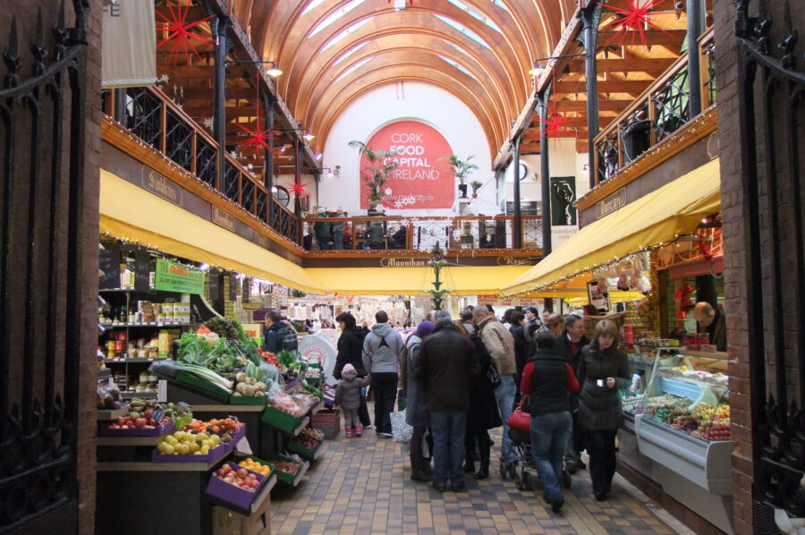
Several of the locations around Cork possess a strong sense of character, culture sentimentality, place and belonging, symbolic ownership and are a source of inspiration – from sites such the Fitzgerald’s Park to Ballincollig Regional Park to Blarney Castle to The Lough, to our universities to the English Market to old industrial sites in Blackpool to the fabric of our city centre streets to woodland trails in Douglas or Glanmire to the towering heritage of St Anne’s Church, Shandon or St Patrick’s Hill – to name a small number of sites. Much has been written over many years on all of the latter sites and their cultural relevance in Cork.
Some sites Corkonians deem such sites as being appealing, timeless, ancestral, eternal, enshrined or sacred in conjuring and summoning a sense of place. Cork possesses a number of sites such as St Anne’s Church Shandon or Pairc Ui Chaoimh, which are synonymous with Cork – they frequently are mentioned to be a representative image of the city.
So it was not on a whim I rolled into the debate on the proposed re-naming of Pairc Ui Chaoimh this week. It is not just the name of the place at stake but what the name means and echos within the heart of Cork’s character, heritage and memory.
There were many ideas bouncing around in my head – the story, legacy and memory of Pádraig Ó Chaoimh – raised in Cork, was a member of the Cork IRA in the Irish War of Independence, secretary to the Cork GAA and then National secretary in the early Irish Free State. His legacy includes doubling the amount of grassroots sports clubs in Ireland and forging club owned premises. There was a strong reason his name was chosen in 1974 for then new Páirc Uí Chaoimh. Pádraig was a legend in his day for many aspects – very much in his development of the GAA in the form we have today as a champion of the culture of the game and the encouragement of young people to join their local clubs and participate in them.
Páirc Uí Chaoimh as a place also possess a strong sense of culture, character, sentimentality, place and belonging, symbolic ownership and is a source of inspiration to those who play on the pitch or support the GAA.
We all become blind to our home place and its stories. We walk streets, which become routine spaces – spaces, which we take for granted – but all have been crafted, assembled and storified by past residents. It is only when we stand still and look around can we hear the voices of the past and its secrets being told, and hopefully build many of them into future, maintaining and enhancing the rich sense of pride and place and history and memory that Cork possesses.
Visit Kieran’s website www.corkheritage.ie for more on Cork history.
Kieran’s Lord Mayor’s Column, The Echo, 20 January 2024
Open for Business:
Cork is open for business and partnership between all stakeholders is crucial going forward. As citizens we need to keep those messages or narratives moving forward for 2024.
In the lead-up to Christmas the support by Corkonians for the traders of Cork was impressive. There were large crowds shopping, attending pantos, engaging in pubs and restaurants. A big thank you to everyone who supported the message of “shop local” this Christmas.
Independent small medium sized businesses are the backbone of the business in Cork and keep the trading environment in Cork unique. Cork has one of the highest proportion of owner led offerings in the country. More than 90% of businesses operating in Cork City employ less than 10 employees and it is these businesses that are the foundation of Cork City’s economy. It is Cork City’s entrepreneur’s and SME’s that will play a key role in achieving Cork’s future vision as well.
Early reports from some traders I have spoken to noted it was a bumper Christmas and even groups such as SHARE reveal larger numbers of people giving generosity more so than ever before. Such positivity is to be welcomed and such momentum on the topic of “shop local” needs to be maintained though in 2024.
Local and National Levers:
The closure of certain restaurants in the past two weeks has brought much sadness and reaction across the media. It is easy to pass the buck on who is to blame. Rarely is there a City Council meeting in City Hall where the challenges of energy costs, insurance, wages, warehousing or deferral of tax debts arising from Covid, rents and rates are raised, and my colleagues call for incentives and more partnership with traders at City Hall level and at national level.
It is important to note that energy costs, insurance, and wages, and deferral of tax debts are in the hands of Central Government and it is very important that they keep not only listening to the ground but also responding to lessen financial challenges. In that regard I welcome the intervention of the Minister of Finance Minister Michael McGrath to sitting down with the city restaurants affected by closure in the past two weeks, and learnings, incentive schemes and appropriate actions taken.
Cork City Council Supports:
From a City Council perspective, there are several supports in place. The income from commercial rates represents 38% of the total income of the City Council. It is a highly important income stream for the City Council. Indeed, up to 80% of the city’s rate payers – paying €4,000-€10,000 a year -also avail of an annual 1.5% rates refund scheme run by the City Council. The extended rates incentive scheme is as per the previous scheme, aimed at SMEs. Contact the Council’s rates department if you are part of the 80%.
On a day-to-day basis, Cork City’s Local Enterprise Office – based at Cork City Hall– also offer a range of supports including business advice, training, mentoring and a range of grants to hundreds of new and more mature businesses across retail and the commercial sector.
“Business Development in Cork: An Entrepreneur’s Guide, 2023” was the first of its kind nationally and provides an extensive overview of the range of supports available from key stakeholders including Cork City Council, Cork County Council, Enterprise Ireland, The Local Enterprise Offices, Cork BIC, University College Cork, and Munster Technological University. There is a drive in Cork that the drive is there to break silos between organisations and development business ecosystems. That is something that needs to be pursued more. New sectors are rapidly emerging in our city.
Investment Continues:
It is also important to note the continued investment into Cork and it is important the narratives do not frighten investors off. Commercial confidence in Cork remains healthy despite the era of higher interest rates and increased cost of living which is impacting householder and business spending in this country and across Europe.
In recent months, acclaimed fashion retailers such as Flannels and Mango opened up stores on St Patricks Street while the former Debenhams block was bought by the Irish company behind the hugely successful Elverys Sports. The new Arc Cinema at The Gate at North Main Street is impressive in its investment.
Last year, a newly refurbished Easons also opened and Cork’s first branch of Krispy Kreme following on from global brands Dune and North Face. This helped support a drop in the city’s commercial vacancy rate.
Furthermore, private sector investors continue to develop student accommodation in the city centre where UCC is due to begin construction of the Cork University Business School (CUBS) and a new Premier inn hotel is also due to open in the coming weeks. Interest in the Cork hospitality sector is proving resilient with the Imperial Hotel being sold for €25 million last year and a new hotel on Camden Quay also due to open later this year.
City Co-Ordination Strategies:
Meanwhile, Cork City Centre is receiving record levels of investment from government agencies and from central government with multi-million projects such as the MacCurtain Street upgrade being delivered while work is due to begin on a refurbished Bishop Lucey Park and the wider transformation of Cork’s medieval quarter, the Grand Parade Quarter.
Cork City Council is also implanting a city centre strategy that is based on best in class international practice. This has included the pedestrianisation of up to 17 streets, widespread outdoor dining, greening and the biggest investment in public art ever seen in the city. There has been a very large and positive engagement by citizens in such projects.
Cork City Council also have a City Centre Co-ordinator who regularly partners with traders. A night-time economy adviser is also now in place.
The most recent census showed that Cork city centre is the area of greatest population growth in the city – a statistic that augurs well for customer demand in the city’s retail, hospitality and cultural sectors.
Yes, there are many challenges but there are also many opportunities that require mining down into through partnership between all stakeholders.
Kieran’s Our City, Our Town, 18 January 2024
Kieran’s Our City, Our Town Article,
Cork Independent, 18 January 2024
Kieran’s Audio Heritage Trails
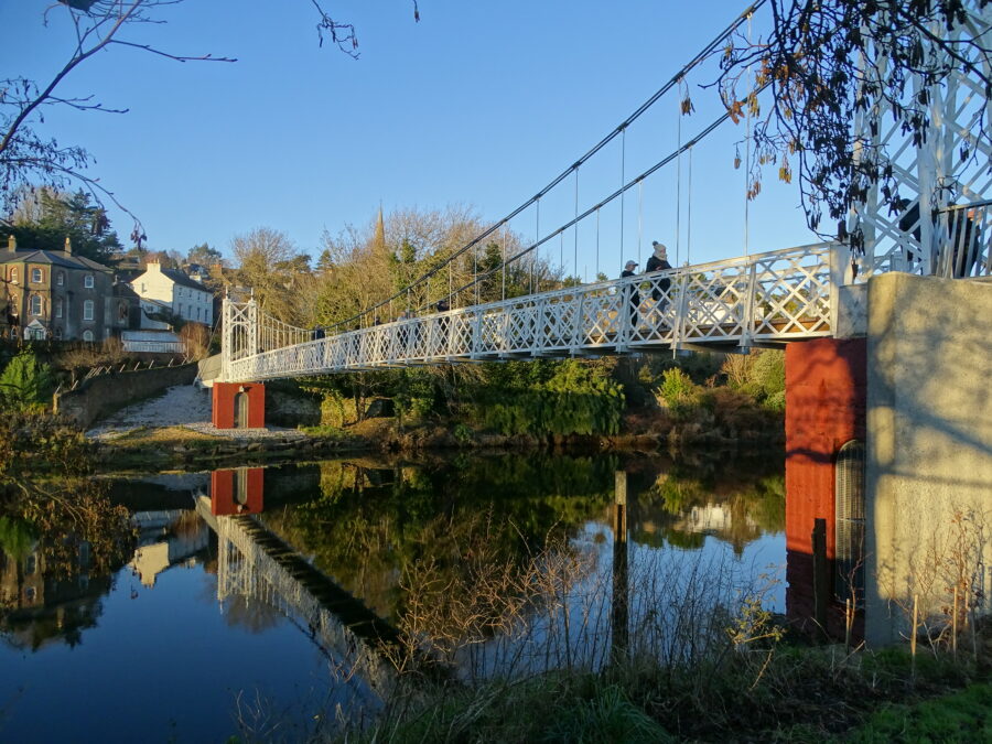
January generally coincides with some fine and cold cold days where walking the city is lit up by wintry Atlantic light. As someone who enjoys photographing the city, it is a good time of year to capture some of the city’s nuanced layers of its past. I hope to launch my physical walking tours again in April but in the meantime, check out my audio heritage trails, which have been developed with Meitheal Mara – on the Bridges of Cork and The Marina respectively.
Both audio trails are hosted on my website www.corkheritage.ie under the history trails section. All you need is your smartphone and some headphones. The first audio trail provides insights into the histories of the Cork city centre’s bridges, their place in Cork and some of their surrounding histories. The walk around the bridges is just over two hours in duration. The trail is clockwise from South Gate Bridge up the south channel and down the north channel to cross back to the south channel. It ends at Nano Nagle Bridge.
They say the best way to get to know a place is to walk it. Through many centuries Cork has experienced every phase of Irish urban development. It is a city you can get lost in narrow streets, marvel at old cobbled lane ways, photograph old street corners, gaze at clues from the past, engage in the forgotten and the remembered, search and connect for something of oneself, and thirst in the sense of story-telling – in essence feel the DNA of the place. With so many layers of history in Cork, there is much to see on any walk around Cork City and its respective neighbourhoods. The River Lee has had and continues to have a key role in the city’s evolution. Many Corkonians and visitors have crossed over the River Lee’s bridges and have appreciated the river’s tranquil and hypnotic flow.
The audio trail begins at the oldest of the city’s bridges – that of South Gate Bridge. In the time of the Anglo Normans establishing a fortified walled settlement and a trading centre in Cork around 1200 AD, South Gate Drawbridge formed one of the three entrances – North Gate Bridge and Watergate being the others. A document for the year 1620 stated that the mayor, Sheriff and commonality of Cork, commissioned Alderman Dominic Roche to erect two new drawbridges in the city over the river where timber bridges existed at the South Gate Bridge and the other at North Gate.
In May 1711, agreement was reached by the Council of Cork Corporation that North Gate Bridge would be rebuilt in stone in 1712 while in 1713, South Gate Bridge would be replaced with a stone arched structure. South Gate Bridge still stands today in its past form as it did over 300 years ago apart from a small bit of restructuring and strengthening in early 1994.
The second of the new audio trails is on The Marina. A stroll down The Marina is popular by many people. The area is particularly characterized by its location on the River Lee and the start of Cork Harbour. Here scenery, historical monuments and living heritage merge to create a historical tapestry of questions of who developed such a place of ideas. Where not all the answers have survived, The Marina is lucky, that archives, newspaper accounts, census records and old maps and other insights have survived to showcase how the area and the wider area has developed. These give an insight into ways of life and ambitions in the past, some of which can help the researcher in the present day in understanding The Marina’s evolution and sense of place going forward.
Cork’s Marina was originally called the Navigation Wall or in essence it was a guidance or tracking wall to bring ships into Cork City’s South Docks area. It was completed in 1761.
Following the constitution of the Cork Harbour Commissioners in 1814 and their introduction of steam dredging, a vigorous programme of river and berth deepening, quay and wharf building commenced. The dredger of the Cork Harbour Commissioners deposited the silt from the river into wooden barges, which were then towed ashore. The silt was re-deposited behind the Navigation Wall.
During the Great Famine, the deepening of the river created jobs for 1,000 men who worked on widening the physical dock of the Navigation Wall. In essence a fine road was constructed, which linked into Cork’s South Docks. To give an aesthetic to the new road, a fine row of elm trees was planted c.1856 by Prof. Edmund Murphy of Queen’s College Cork (now UCC). The elm trees were part of a crop and tree growing experiment.
In 1870, the Gaelic poet and scholar Donncha Ó Floinn put forward to the Improvements Committee of Cork Corporation that the new road of the Navigation wall be named Slí na hAbhann, which means the ‘pathway by the river’. Ó Floinn’s proposal was not accepted. The matter came before the Improvements Committee again in 1872. This time Ó Floinn suggested that the promenade be named ‘The Marina’. He outlined that ‘The Marina’ was the name allocated to a recently reclaimed piece of land near Palermo in Sicily. In July 1872, Cork Corporation formally adopted ‘The Marina’ as the name of the new road or promenade.
Listen to Kieran’s audio heritage trails under history trails at www.corkheritage.ie
Captions:
1236a. Daly’s Bridge aka Shaky Bridge, present day, which is one of the featured bridges in Kieran’s audio heritage trail of the Bridges of Cork (picture: Kieran McCarthy).
Kieran’s Our City, Our Town, 11 January 2024
Kieran’s Our City, Our Town Article,
Cork Independent, 11 January 2024
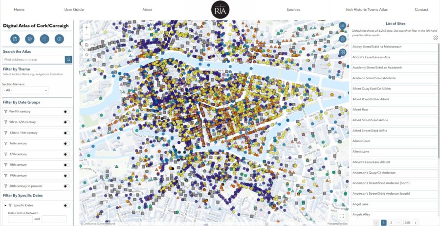
The New Digital Atlas of Cork
They say the best way to get to know a city is to walk it – and in these early January days it is an ideal time. In Cork you can get lost in narrow streets, marvel at old cobbled lane ways, photograph old street corners, look up beyond the modern shopfronts, gaze at clues from the past, be enthused and at the same time disgusted by a view, smile at interested locals, engage in the forgotten and the remembered, search and connect for something of oneself, thirst in the sense of story-telling – in essence feel the DNA of the place.
Giving walking tours for over 30 years has allowed me to bring people on a journey into that soul but also receive feedback on the wider contexts of what visitors and locals have seen elsewhere. Cork is a city packed with historic gems all waiting to be discovered at every street corner.
Cork has a soul, which is packed full of ambition and heart. Cork’s former historic networks and contacts are reflected in its the physical urban fabric – its bricks, street layout and decaying timber wharfs. Inspired by other cities with similar trading partners, it forged its own unique take on port architecture.
So the new Digital Atlas of Cork/ Corcaigh is very welcome. It is one of a series of digital atlases created by the Irish Historic Towns Atlas team (the others are Derry, Dungarvan and Galway). The Digital Atlas of Cork/Corcaigh is an initiative of the Digital Working Group of the Irish Historic Towns Atlas research programme. The project has been led by Sarah Gearty (Royal Irish Academy) and Rachel Murphy (University of Limerick), with Mani Morse (Dublin City University) as Digital Manager.
The Digital Atlas of Cork/Corcaigh is a free online interactive map that invites you to discover the built heritage of Cork City in a new way where 6,245 features of the city’s history from AD 623 to 1900 are mapped. The atlas includes descriptions of over 800 streets, including their names in Irish and English as well as historical variants.
Users can browse the digital atlas or search for a specific site in the city. They can also select and view features associated with specific time periods, from medieval times to the present day. Most notably, it maps out Cork’s earlier historical sites especially around South and North Main Street and its Viking age history and Anglo Norman history.
Each historical feature is represented by a coloured symbol, each feature has been categorized into one of eleven different themes such as entertainment, manufacturing, religion and transport. When a user clicks on a feature, key information about it is displayed in a pop-up box.
A specially commissioned historical map depicts each individual house and plot during the mid-nineteenth century (1842). This is just one of a number of layered maps that may be switched on and off to show how the city developed over the centuries.
Other layers include Ordnance Survey maps — a present-day plan of the city, as well as historic maps showing Cork pre-Great Famine and at the turn of the twentieth century. Additional map layers will be released over the coming months, providing access for the first time to digitised town plans by the Ordnance Survey (1842) and Valuation Office (1852–64).
A downloadable user guide has been created to accompany the resource, to allow anyone to explore the Digital Atlas with further education and project work in mind. The project has been part funded by the Heritage Council Stewardship Fund 2023. It has been supported by partners Cork City Council, the Digital Repository of Ireland, the National Archives of Ireland and Táilte Éireann.
The Digital Atlas is remarkable with over 6,000 entries. It is a tremendous new resource for all the people of Cork and will no doubt instil a sense of pride in local communities, through its use in schools and libraries. In particular, the research and further reading aspect of the atlas will be a great source for anyone with an interest in the history and development of Cork City. This innovative project from the Royal Irish Academy will make the valuable research of the Irish Historic Towns Atlas series available to a wider and more varied audience than heretofore.
The atlas will contribute immensely to the work of Cork City Council and the wider professional community in Cork particularly those working in archives, museums, education, planning, architecture and conservation. Ciara Brett, City Archaeologist, Cork City Council noted of the Digital Atlas:
“The Digital Atlas, when utilised with the forthcoming printed Atlas, will be a great benefit to the study of the changing urban environment and will provide practical assistance in the preparation and implementation of planning policy and development management in the City. The IHTA Cork/Corcaigh volume in digital format will add to the existing corpus of published material and will, I believe, encourage future research and study that will enhance our understanding and appreciation of our city”.
The Digital Atlas of Cork/Corcaigh is based on research carried out for Irish Historic Towns Atlas, no. 31, Cork/Corcaigh by Howard B Clarke and Máire Ní Laoi, which will be published by the Royal Irish Academy in print in May 2024.
Based at the Royal Irish Academy, the Irish Historic Towns Atlas research programme traces the topographical development of towns, cities and suburbs through its atlas and ancillary publications, annual seminars and special exhibitions. It is part of a wider international scheme that covers nineteen countries. The Irish programme is considered a leader in the development of digital atlases of this kind.
For more log onto www.ria.ie/digital-atlas-corkcorcaigh
Caption:
1235a. Screen grab of the Digital Atlas of Cork.
Kieran’s Lord Mayor’s Column, 6 January 2024
Discover Cork Through a New Digital Atlas:
They say the best way to get to know a city is to walk it – and a new year with crisp early January days is an ideal time. In Cork you can get lost in narrow streets, marvel at old cobbled lane ways, photograph old street corners, look up beyond the modern shopfronts, gaze at clues from the past, be enthused and at the same time disgusted by a view, smile at interested locals, engage in the forgotten and the remembered, search and connect for something of oneself, thirst in the sense of story-telling – in essence feel the DNA of the place.
Giving walking tours for over 30 years has allowed me to bring people on a journey into that soul but also receive feedback on the wider contexts of what visitors and locals have seen elsewhere. Cork is a city packed with historic gems all waiting to be discovered at every street corner.
Cork has a soul, which is packed full of ambition and heart. Cork’s former historic networks and contacts are reflected in its the physical urban fabric – its bricks, street layout and decaying timber wharfs. Inspired by other cities with similar trading partners, it forged its own unique take on port architecture.
So the new Digital Atlas of Cork/ Corcaigh is very welcome. It is one of a series of digital atlases created by the Irish Historic Towns Atlas team (others are Derry, Dungarvan and Galway). The Digital Atlas of Cork/Corcaigh is an initiative of the Digital Working Group of the Irish Historic Towns Atlas research programme. The project has been led by Sarah Gearty (Royal Irish Academy) and Rachel Murphy (University of Limerick), with Mani Morse (Dublin City University) as Digital Manager.
The Digital Atlas of Cork/Corcaigh is a free online interactive map that invites you to discover the built heritage of Cork City in a new way where 6,245 features of the city’s history from AD 623 to 1900 are mapped. The atlas includes descriptions of over 800 streets, including their names in Irish and English as well as historical variants.
View the atlas here: Digital Atlas of Cork/Corcaigh | Royal Irish Academy (ria.ie)
Users can browse the digital atlas or search for a specific site in the city. They can also select and view features associated with specific time periods, from medieval times to the present day. Most notably, it maps out Cork’s earlier historical sites especially around South and North Main Street and its Viking age history and Anglo Norman history.
Each historical feature is represented by a coloured symbol, each feature has been categorized into one of eleven different themes such as entertainment, manufacturing, religion and transport. When a user clicks on a feature, key information about it is displayed in a pop-up box.
A specially commissioned historical map depicts each individual house and plot during the mid-nineteenth century (1842). This is just one of a number of layered maps that may be switched on and off to show how the city developed over the centuries.
Other layers include Ordnance Survey maps — a present-day plan of the city, as well as historic maps showing Cork pre-Famine and at the turn of the twentieth century. Additional map layers will be released over the coming months, providing access for the first time to digitised town plans by the Ordnance Survey (1842) and Valuation Office (1852–64).
A downloadable user guide has been created to accompany the resource, to allow anyone to explore the Digital Atlas with further education and project work in mind. The project has been part funded by the Heritage Council Stewardship Fund 2023. It has been supported by partners Cork City Council, the Digital Repository of Ireland, the National Archives of Ireland and Tailte Éireann.
The Digital Atlas is remarkable with over 6,000 entries. It is a tremendous new resource for all the people of Cork and will no doubt instil a sense of pride in local communities, through its use in schools and libraries. In particular, the research and further reading aspect of the atlas will be a great source for anyone with an interest in the history and development of Cork City. This innovative project from the Royal Irish Academy will make the valuable research of the Irish Historic Towns Atlas series available to a wider and more varied audience than heretofore.
The atlas will contribute immensely to the work of Cork City Council and the wider professional community in Cork particularly those working in archives, museums, education, planning, architecture and conservation. Ciara Brett, City Archaeologist, Cork City Council noted of the Digital Atlas:
“The Digital Atlas, when utilised with the forthcoming printed Atlas, will be a great benefit to the study of the changing urban environment and will provide practical assistance in the preparation and implementation of planning policy and development management in the City. The IHTA Cork/Corcaigh volume in digital format will add to the existing corpus of published material and will, I believe, encourage future research and study that will enhance our understanding and appreciation of our city”.
The Digital Atlas of Cork/Corcaigh is based on research carried out for Irish Historic Towns Atlas, no. 31, Cork/Corcaigh by H.B. Clarke and Máire Ní Laoi, which will be published by the Royal Irish Academy in print in May 2024.
Based at the Royal Irish Academy, the Irish Historic Towns Atlas research programme traces the topographical development of towns, cities and suburbs through its atlas and ancillary publications, annual seminars and special exhibitions. It is part of a wider international scheme that covers nineteen countries. The Irish programme is considered a leader in the development of digital atlases of this kind.
Kieran’s Our City, Our Town, 4 January 2023
Kieran’s Our City, Our Town Article,
Cork Independent, 4 January 2024
Past Projections into the Future
The more one studies the vast stories at play in Cork City, the more they pull you in to study them more. The more they pull you in the more one gets under the skin of our historic city; one becomes even more enamoured by the rake of very interesting stories, which created our beautiful city.
In recent months one interesting project in the guise of Island City Sculpture Trail, has harnessed Cork’s urban environment and its heritage and history to bring art to the streets of Cork. The temporary artworks are located on Carey’s Lane, the Exchange Building on Princes Street, Cook Street, Cornmarket Street and soon at Triskel Christchurch.
Island city Sculpture Trail at its heart reflects on how lucky we are in Cork to have a wider heritage and historical contexts, which all add to Cork’s a strong sense of memory and a strong sense of place.
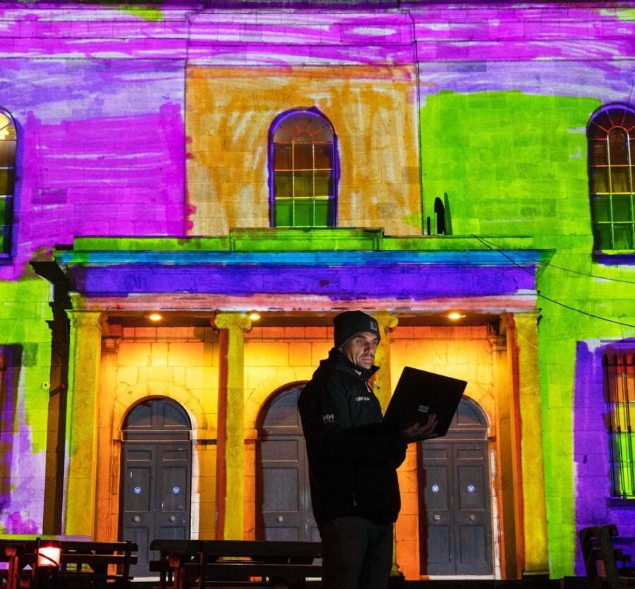
Tempus Futurum by Brian Kenny is a light projection onto Triskel Christchurch that takes viewers on a journey through the building’s rich history, present and future. Brian is a video artist and projection mapping specialist whose work focuses on the transformation of environments through the manipulation of lighting and video technology. His video and projection mapping work spans all formats of presentation from contemporary galleries to large-scale outdoor productions. He is the founder and Creative Director of Lightscape Visuals, an award-winning studio specialising in projection mapping, live visuals and immersive and interactive environments.
On the historic South Main Street there is an abundance of stories, memories, and curiosities. It is a former rushes and reeds swampland. On top of that a Hiberno-Norse settlement grew. Some of their foundational timber structures still exist and are so compacted beneath the ground because of our pressure on them. It was they who also built the first South Gate Bridge – a flimsy timber structure, which has changed at least four-five times over the past thousand years.
South Main Street became a former impressive street of the walled town of Cork, whose width was originally probably about three metres and where light onto the street was limited.
Christ Church is the fourth building on the site for Christ Church over the past 1,000 years. It’s current crypt hosting names of families from 17th and 18th century Cork whose names are embedded in street names – for example Tuckey Street.
South Main Street is a street that had once was one of the largest breweries in the South of Ireland in the guise of Beamish and Crawford. It is a street where arches such as those on the southern end of Bishop Lucey Park highlight one of the largest clothing companies in 19th century in the guise of Lyons Clothing Company.
Bishop Lucey Park, soon to be revamped with its impressive array of monuments, hosts a piece of the town wall of Cork’s Anglo-Norman walled town to a 1798 rebellion memorial, and boxing memorials. The park is a nod to the 800th anniversary of Cork becoming an official market place complete with a mayor, councillors and sheriffs.
The list of historical stories goes on – the story of the debtor’s prison, the story of Hanover Street and the House of Hanover connection, the story of Lane’s Brewery, the story of the Wide Street Commission, the earlier nineteenth yellow slob brick from Douglas Estuary in the current buildings on the street, the story of the naming of George Washington Street, the story of the Triskel Arts Centre, and the story of the Sir Henry’s Night Club. South Main Street is very fortunate to have such heritage, history and memory.
Brian Kenny’s remarkable, digitally mapped, moving image artwork is projected onto the South Main Street façade of the Christ Church, which is over 300 years old. Each evening from dusk, for up to seven months a year, the captivating 10-minute looped moving visuals will be projected for all to enjoy.
Tempus Futurum is inspired by the motto “A society thrives when elders plant trees under whose shade they’ll never rest”. It delves into past, present, and an imminent future, exploring human impact on the environment.
Amidst this journey, the perspectives of 50 local schoolchildren breathe life into the projection, offering reflections on the building’s future. Their youthful imaginations visualise a world shaped by present actions – a reminder that our choices today echo into tomorrow’s legacy.
Beginning with a interpretation of unharmed forests untouched by humanity, the first scene evokes the beauty of nature in its untouched form. Transitioning, the arrival of human settlement marks a central juncture, signalling the beginning of cultivation and humanity’s imprint on the landscape – a forerunner to the city’s birth.
Brian invites reflection into one’s relationship with the location and the city’s evolution. The artwork stresses that even in the face of an uncertain future, our actions echo – a testament to the legacy we leave for generations yet to come.
Brian notes of his narrative: “As viewers immerse themselves in this thought-provoking narrative, they become integral threads in the tapestry of time, realising that our relationship with our surroundings isn’t solitary but part of an enduring continuum—a reminder that our choices today shape the shadows cast upon the landscapes of tomorrow”.
Read more on: www.corkcity.ie/en/island-city-cork-s-urban-sculpture-trail
Happy New Year to all readers.
Caption:
1234a. Artist Brian Kenny at Tempus Futurum at Triskel ChristChurch, December 2023 (picture: Cork City Council).
Happy Christmas
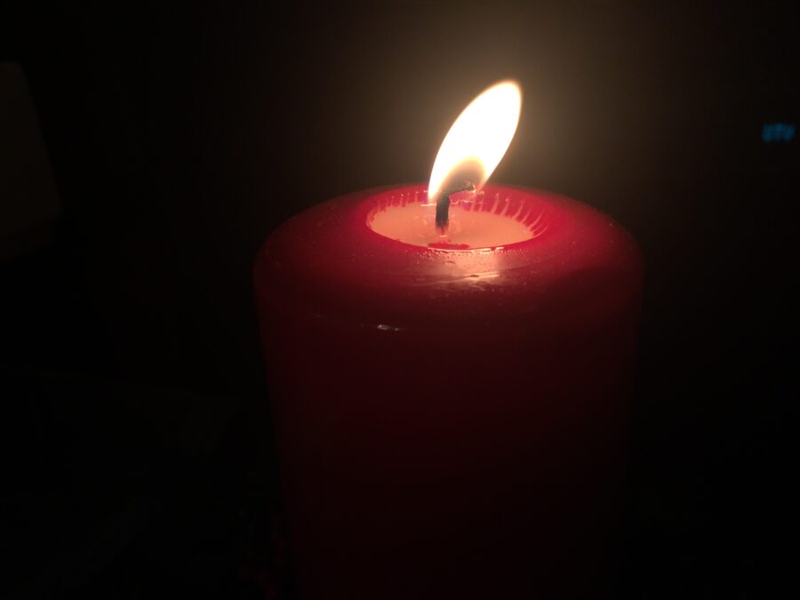
The Blessing of a Candle
by Lord Mayor of Cork Cllr Kieran McCarthy
Sturdy on a table top and lit by youngest fair,
a candle is blessed with hope and love, and much festive cheer,
Set in a wooden centre piece galore,
it speaks in Christian mercy and a distant past of emotional lore,
With each commencing second, memories come and go,
like flickering lights on the nearest Christmas tree all lit in traditional glow,
With each passing minute, the flame bounces side to side in drafty household breeze,
its light conjuring feelings of peace and warmth amidst familiar blissful degrees,
With each lapsing hour, the residue of wax visibly melts away,
whilst the light blue centered heart is laced with a spiritual healing at play,
With each ending day, how lucky are those who love and laugh around its glow-filledness,
whilst outside, the cold beats against the nearest window in the bleak winter barreness,
Fear and nightmare drift away in the emulating light,
both threaten this season in almighty wintry flight,
Sturdy on a table top and lit by youngest fair,
a candle is blessed with hope and love, and much festive cheer.